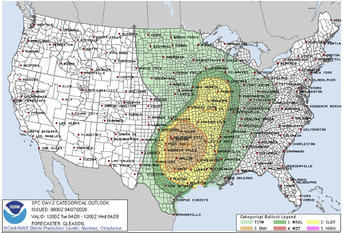
Hey guys, welcome back to Weather Center! So WC has got more of the latest data and it wants to share it with you. The potential for Severe Weather on Tuesday has upped to a Enhanced Risk for North Texas and other places. So to keep it simple and short… there are 2 scenarios.
Cap holds during the afternoon and then IF it breaks, it will bring potential severe storms for North Texas in the evening hours as they move West to East.
OR cap holds until the cold front comes, then it probably will break and then storms could be severe, maybe even slightly stronger and the storms will happen late evening into night on Tuesday.
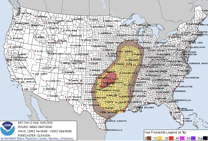
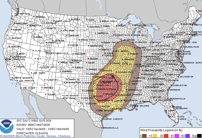
All these scenarios produce a chance of Large Hail and Strong Winds for North Texas.
Convective OutlookTornado OutlookHail OutlookWind Outlook
SPC AC 270600
Day 2 Convective Outlook
NWS Storm Prediction Center Norman OK
0100 AM CDT Mon Apr 27 2020
Valid 281200Z - 291200Z
...THERE IS AN ENHANCED RISK OF SEVERE THUNDERSTORMS ACROSS PARTS OF
THE SOUTHERN PLAINS INTO THE OZARKS AND ARKLATEX...
...SUMMARY...
Scattered to numerous severe thunderstorms are expected Tuesday
across parts of the southern/central Plains into the lower/mid
Mississippi Valley and Midwest. Scattered large to very large hail,
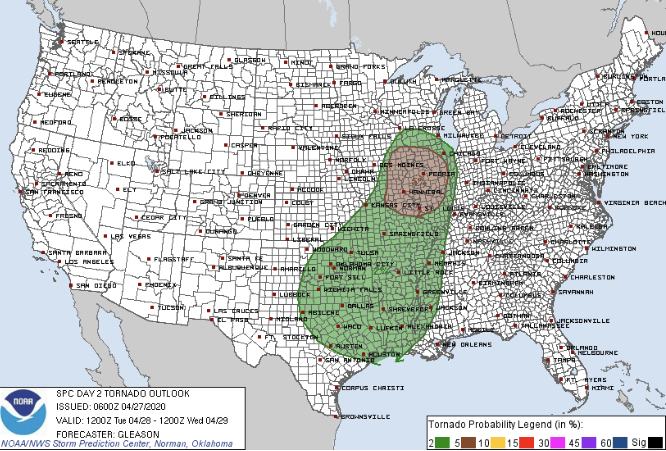
numerous severe wind gusts (some significant), and a few tornadoes
may occur.
...Southern Plains into the ArkLaTex and Lower Mississippi Valley...
A shortwave trough will dig southeastward from the northern
Rockies/Plains to the MS Valley on Tuesday. As it does so, a surface
low is forecast to develop eastward across the Upper Midwest to
southern WI by Tuesday evening. Low-level moisture return will occur
in earnest across the southern Plains into parts of the ArkLaTex,
with mid 60s to low 70s surface dewpoints becoming common. A surface
dryline will extend southward from a thermal low across the southern
High Plains, and steep mid-level lapse rates will be present over
much of the warm sector. With ample diurnal heating expected,
moderate to very strong instability (MLCAPE 2000-4000 J/kg) appears
likely to develop by peak afternoon heating. Convection will quickly
form and then explosively strengthen along a southeastward-moving
cold front across southern KS/northern OK by late Tuesday afternoon,
with initiation along the dryline more uncertain given at least some
residual low-level capping.
Although low-level flow is not forecast to be particularly strong,
mid/upper-level northwesterly winds will strengthen through the late
afternoon into the overnight as the shortwave trough shifts
southeastward. Effective bulk shear is likewise forecast to increase
sufficiently to support supercells with initial development along
the cold front. Scattered large to very large hail will likely be
the main threat so long as storms can remain semi-discrete. By early
evening, upscale growth along the front will likely occur, with one
or more bowing segments moving quickly southeastward across parts of
central/eastern OK into north-central/northeast TX and the ArkLaTex
region. Although convective inhibition will increase some through
the evening, the well organized nature of the convection and large
instability reservoir will likely support a swath of numerous to
potentially widespread damaging winds, some of which could be
significant. A tornado or two also cannot be ruled out. Eventually,
the line should weaken with southward extent into the lower MS
Valley and coastal TX as it outpaces the stronger shear/forcing
associated with the shortwave trough.
...Central Plains/Ozarks into the Mid Mississippi Valley and
Midwest...
Latest guidance has come into better agreement with the evolution of
the surface low and potential for more robust instability to develop
across parts of the mid MS Valley by Tuesday afternoon. Both
low-level flow and shear should be somewhat stronger across this
region compared to locations farther south. At least semi-discrete
supercells appear probable from portions of southeastern IA into
northern/central MO and IL. At least isolated large hail may occur,
along with some damaging winds if storms can grow upscale into one
or more small clusters. A few tornadoes also appear possible from
late Tuesday afternoon through early evening along/south of the warm
front given a favorable storm mode and sufficient low-level shear.
By late Tuesday evening into the overnight hours, storms should
weaken as they encounter a less unstable airmass over parts of the
Mid-South and western KY/IN.
..Gleason.. 04/27/2020
To decode this SPC statement… just wait and see folks 🙂 don’t worry about it but do PLEASE as weather aware. We do have a chance of storms with Large Hail and Winds, NOT tornadoes most likely. Do prepare if needed.
Hey guys, welcome back to Weather Center! So WC has got more of the latest data and it wants to share it with you. The potential for Severe Weather on Tuesday has upped to a Enhanced Risk for North Texas and other places. So to keep it simple and short… there are 2 scenarios.
Cap holds during the afternoon and then IF it breaks, it will bring potential severe storms for North Texas in the evening hours as they move West to East.
OR cap holds until the cold front comes, then it probably will break and then storms could be severe, maybe even slightly stronger and the storms will happen late evening into night on Tuesday.
All these scenarios produce a chance of Large Hail and Strong Winds for North Texas.
Convective OutlookTornado OutlookHail OutlookWind Outlook
SPC AC 270600

   Day 2 Convective Outlook
   NWS Storm Prediction Center Norman OK
   0100 AM CDT Mon Apr 27 2020

   Valid 281200Z - 291200Z

   ...THERE IS AN ENHANCED RISK OF SEVERE THUNDERSTORMS ACROSS PARTS OF
   THE SOUTHERN PLAINS INTO THE OZARKS AND ARKLATEX...

   ...SUMMARY...
   Scattered to numerous severe thunderstorms are expected Tuesday
   across parts of the southern/central Plains into the lower/mid
   Mississippi Valley and Midwest. Scattered large to very large hail,
   numerous severe wind gusts (some significant), and a few tornadoes
   may occur.

   ...Southern Plains into the ArkLaTex and Lower Mississippi Valley...

   A shortwave trough will dig southeastward from the northern
   Rockies/Plains to the MS Valley on Tuesday. As it does so, a surface
   low is forecast to develop eastward across the Upper Midwest to
   southern WI by Tuesday evening. Low-level moisture return will occur
   in earnest across the southern Plains into parts of the ArkLaTex,
   with mid 60s to low 70s surface dewpoints becoming common. A surface
   dryline will extend southward from a thermal low across the southern
   High Plains, and steep mid-level lapse rates will be present over
   much of the warm sector. With ample diurnal heating expected,
   moderate to very strong instability (MLCAPE 2000-4000 J/kg) appears
   likely to develop by peak afternoon heating. Convection will quickly
   form and then explosively strengthen along a southeastward-moving
   cold front across southern KS/northern OK by late Tuesday afternoon,
   with initiation along the dryline more uncertain given at least some
   residual low-level capping.

   Although low-level flow is not forecast to be particularly strong,
   mid/upper-level northwesterly winds will strengthen through the late
   afternoon into the overnight as the shortwave trough shifts
   southeastward. Effective bulk shear is likewise forecast to increase
   sufficiently to support supercells with initial development along
   the cold front. Scattered large to very large hail will likely be
   the main threat so long as storms can remain semi-discrete. By early
   evening, upscale growth along the front will likely occur, with one
   or more bowing segments moving quickly southeastward across parts of
   central/eastern OK into north-central/northeast TX and the ArkLaTex
   region. Although convective inhibition will increase some through
   the evening, the well organized nature of the convection and large
   instability reservoir will likely support a swath of numerous to
   potentially widespread damaging winds, some of which could be
   significant. A tornado or two also cannot be ruled out. Eventually,
   the line should weaken with southward extent into the lower MS
   Valley and coastal TX as it outpaces the stronger shear/forcing
   associated with the shortwave trough.

   ...Central Plains/Ozarks into the Mid Mississippi Valley and
   Midwest...
   Latest guidance has come into better agreement with the evolution of
   the surface low and potential for more robust instability to develop
   across parts of the mid MS Valley by Tuesday afternoon. Both
   low-level flow and shear should be somewhat stronger across this
   region compared to locations farther south. At least semi-discrete
   supercells appear probable from portions of southeastern IA into
   northern/central MO and IL. At least isolated large hail may occur,
   along with some damaging winds if storms can grow upscale into one
   or more small clusters. A few tornadoes also appear possible from
   late Tuesday afternoon through early evening along/south of the warm
   front given a favorable storm mode and sufficient low-level shear.
   By late Tuesday evening into the overnight hours, storms should
   weaken as they encounter a less unstable airmass over parts of the
   Mid-South and western KY/IN.

   ..Gleason.. 04/27/2020
To decode this SPC statement… just wait and see folks 🙂 don’t worry about it but do PLEASE as weather aware. We do have a chance of storms with Large Hail and Winds, NOT tornadoes most likely. Do prepare if needed.
When you login first time using a Social Login button, we collect your account public profile information shared by Social Login provider, based on your privacy settings. We also get your email address to automatically create an account for you in our website. Once your account is created, you'll be logged-in to this account.
DisagreeAgree
Connect with
I allow to create an account
When you login first time using a Social Login button, we collect your account public profile information shared by Social Login provider, based on your privacy settings. We also get your email address to automatically create an account for you in our website. Once your account is created, you'll be logged-in to this account.