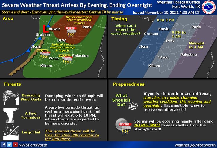
A very strong upper level jet storm system will move into DFW around 7-10 PM. This severe storm system will move in very quickly along with a cold front. This system could pack a punch with large hail, some high winds, and maybe a few tornadoes. Remember this storm will begin around Sherman Texas and will extend all the way as north as northern Arkansas and extend down towards Waco. This storm could be moving at a speed close to 25-35 mph which means it can catch many of us by surprise. Take a look at this Simulated Model Radar.

NWS Alert Message
“A vigorous upper level jet stream and disturbance, along with a surface cold front arrive this evening, before moving away from the area to the east by sunrise Thursday. There will be enough moisture, instability, and lift to develop thunderstorms, some of which will be isolated and discrete in nature between 6 pm to 10 pm. Larger hail and damaging winds will be the primary threats. During this window, a low tornado threat will also exist, with the greatest threat north of I-20 and especially closer to the Red River. Severe weather coverage will be more isolated across Central Texas. By midnight and after, storms will convergence into a broken squall line along the cold front with damaging winds becoming the primary hazard.”
Live Storm Info
Stay Weather Aware Tonight!
Become a TWC Member today for FREE!
Support Texas Weather Center
Join the TWC Membership through Patreon to show your support and keep TWC high quality and FREE!
Texas Weather Center Supporters
🥉Kathryn
🥇David Bass
🥉cslewis1234
🥉Robert Fasulo
🥈Carol