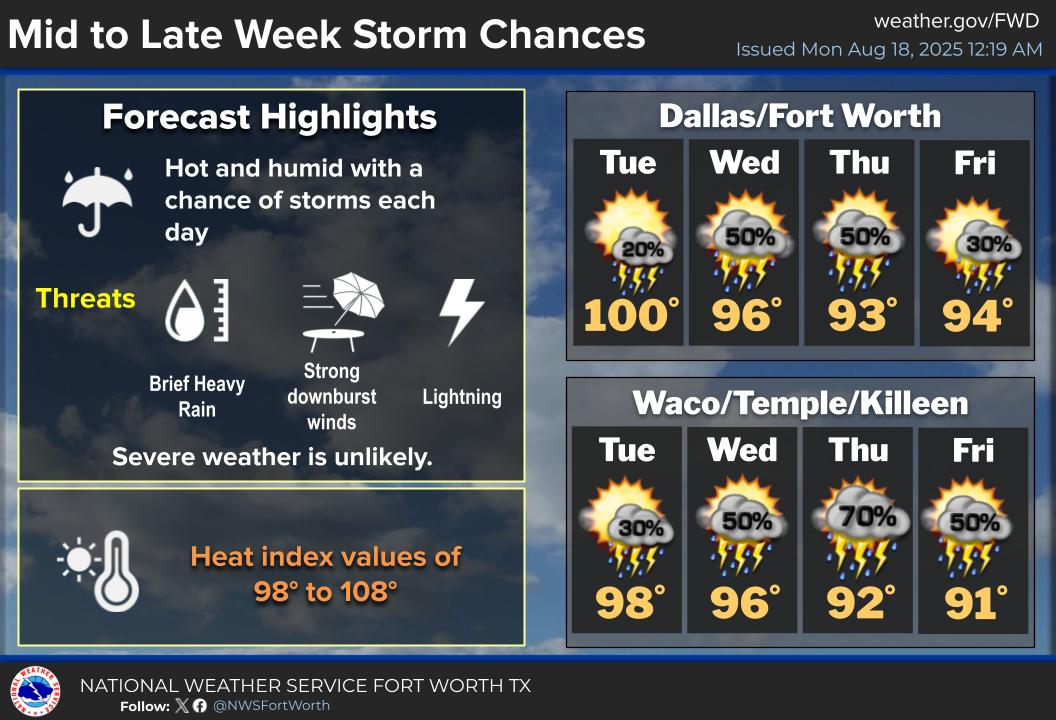
The next coming days will be potentially very active for DFW in severe weather! Just how active? Well, we are looking at severe weather for DFW possibly 4 days in a row due to a massive storm system that will be sweeping through the plains this weekend. Not everyone will see severe weather from this system but it does pose a threat of gorilla hail, damaging winds, and tornadoes.
Thursday
Severe weather will be plentiful in West Texas extending up northward into western Oklahoma and Kansas. The main threats with this system so far seem to be large hail and damaging wind gusts. DFW is not within the threat area for this system as of now.
Friday
The same storm system moves eastward on Friday afternoon into the DFW area while being pushed by a dry line. This will result in all modes of severe weather possible… large hail, damaging winds, and a few tornadoes.
Saturday & Sunday
Another storm system will move into the DFW area on Saturday afternoon/evening into Sunday. Storm Prediction Center currently does not have much information out for these days on severe weather. However, models indicate a very strong CAPE that will be in place, with some values as high as 4,000 J/kg (indicating extreme storm activity could be possible). The timing and the hazards of these storms are uncertain at the moment, but DFW is expected to be impacted in some way by this storm system. WC will be monitoring the tornado risk due to the concern of a possible spike in activity for these 2 days.
More details will be coming soon on each individual threat later this week. Stay weather aware
Become a TWC Member today for FREE!
Support Texas Weather Center
Join the TWC Membership through Patreon to show your support and keep TWC high quality and FREE!
Texas Weather Center Supporters
🥉Kathryn
🥇David Bass
🥉cslewis1234
🥉Robert Fasulo
🥈Carol