This page on cloud types will give you a basic understanding of some of the most common clouds plus some rare clouds. All clouds are made up of small water droplets or ice crystals, but there are many variants to clouds. Some are big, some are small. Some are high up in the sky, some are close to the surface. Below you will begin to learn the different types. Afterward, you will be such a wiz at your cloud facts, and you can “wow” your friends as you spot these clouds in the sky on an average day!
High Altitude Cloud Types (16,500-45,000+ ft)
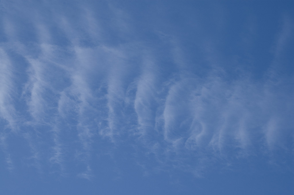
Cirrus
Cirrus clouds are feathery strand like clouds made up of ice crystals. They take their shape by upper-level winds blowing them around into different shapes.
Weather Condition = Possibly cold. Often with frontal systems meaning a weather change is coming.
Cirrostratus
Cirrostratus clouds are large thin sheet-like clouds that cover the majority of the sky. They are often frequently found during wintertime and they can appear to cast a halo around the sun or the moon when they are present.
Weather Condition = Possibly rain or snow on its way. Could arrive within 12-24 hours.
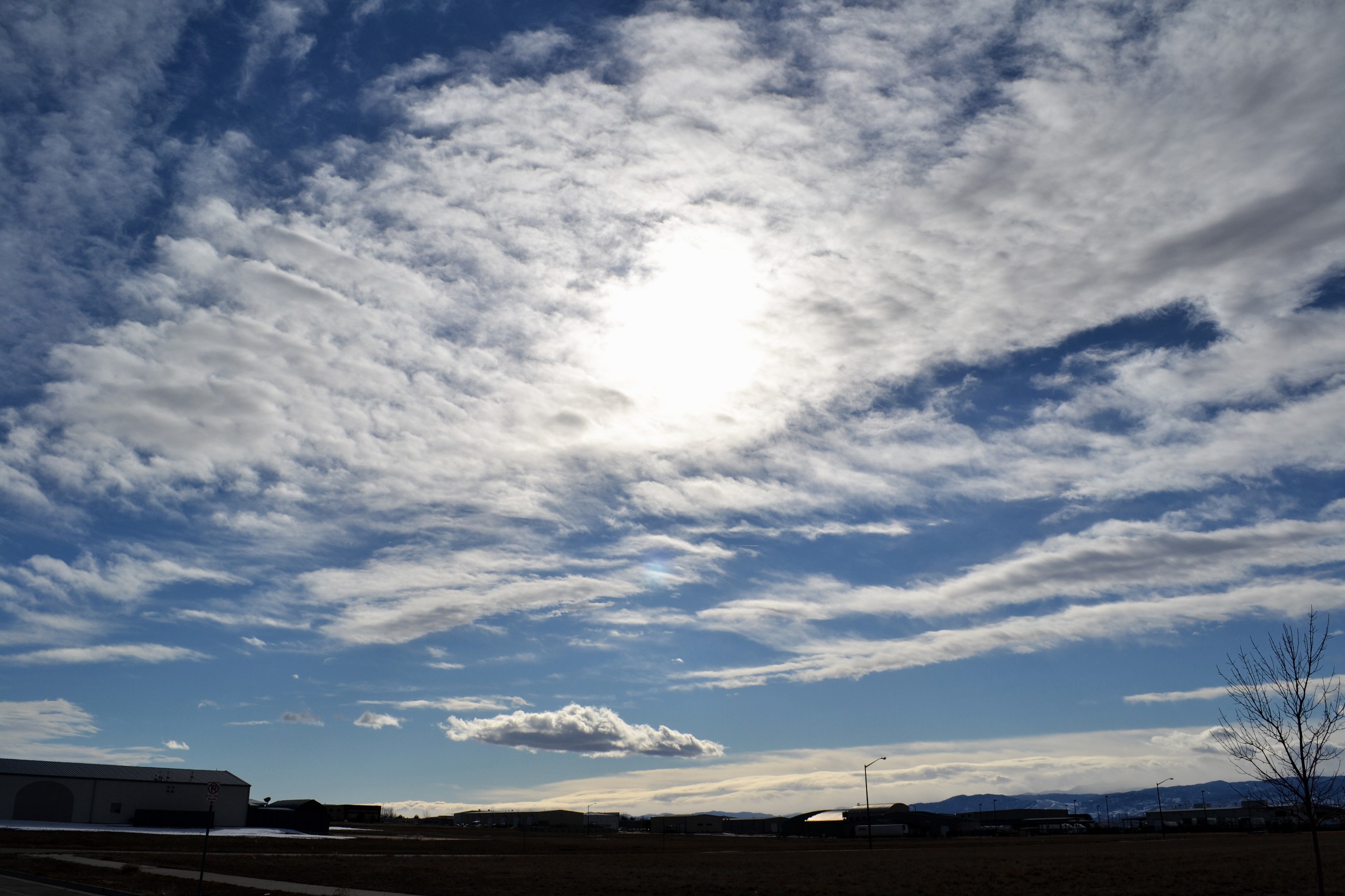
Cirrocumulus
Cirrocumulus are thin patchy sheet-like clouds that blanket the sky. They can appear to have ripples or be very small and numerous.
Weather Condition = Possibly cold. Fair weather is usually present when these clouds are around.
Mid Altitude Cloud Types (6,500-23,000 ft)
Altocumulus
Altocumulus clouds are repetitive patchy clouds typically in rows. These clouds are made of water droplets.
Weather Condition = Fair weather
Altostratus
Altostratus clouds are gray sheet clouds made up of water droplets that typically cover the entire sky.
Weather Condition = Continual rain or snow is possible later
Nimbostratus
Nimbostratus clouds are dark low rain clouds which are known for heavy rain. They typically are very thick and reduce sunlight significantly.
Weather Condition = Gloomy, continual heavy rain or snow
Low Altitude Cloud Types (less than 6,500 ft)
Cumulus
Cumulus clouds, known for their rising abilities, appear as white fluffy cotton balls. They can vary in shape and size. Often they can be some of the most fascinating fair weather clouds to observe.
Weather Condition = Fair weather
Stratus
Stratus clouds appear like sheets covering the sky. They sometimes come down to very low altitudes and appear almost like a fog. Sometimes these clouds can cover the whole sky.
Weather Condition = Fair weather, sometimes gloomy conditions
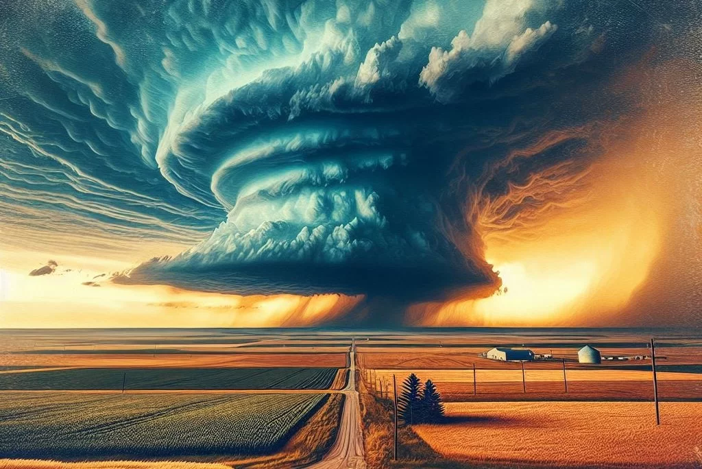
Cumulonimbus
Cumulonimbus clouds are some of the most impressive clouds of all. They are known for their severe storm producing capabilities, and their ability to grow up to 50,000 ft up! They form from warm moist rising air. Read more here
Weather Condition = Severe weather capable of producing large hail, damaging winds, and tornadoes
Special Cloud Types (less than 6,500 ft)
Mammatus
Mammatus clouds form most of the time on the back under side of a cumulonimbus thunderstorm cloud. They form when cold air within the cloud sinks and causes a pouch like shape. These clouds can be some of the strangest!
Weather Condition = Indicator that severe weather is either nearby or on its way
Shelf Cloud
Shelf clouds can be some of the most ominous clouds! These clouds usually form on the leading edges of strong thunderstorms. They appear very low to the ground and typically move very quickly.
Weather Condition = Indicative of strong/severe weather coming soon in the storm. Usually windy
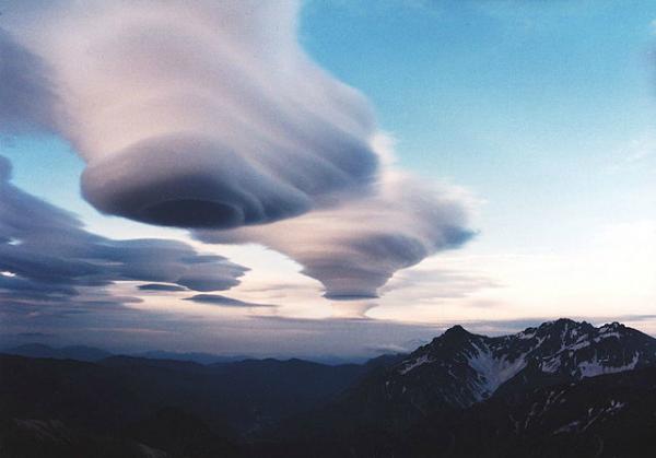
Lenticular
Lenticular clouds are layered clouds that typically form over mountains. They often look like floating lenses, and they get their shape by how air moves over terrain.
Weather Condition = No effect, usually fair weather
Morning Glory
Morning glory clouds, AKA roll clouds, are stunning clouds for sure! Some say they are the rarest cloud formation. They appear as long rolls that can stretch across much of the atmosphere. They form when a downdraft meets rising warm air by an advancing front. Many factors must be perfect for this cloud to form!
Weather Condition = Fair weather, sometimes thunderstorms nearby
Kelvin Helmholtz
Kelvin Helmholtz clouds, AKA wave clouds, are some of the most unique and rare clouds! They are formed when two air currents meet in the atmosphere at the same time.
Weather Condition = Fair weather, sometimes windy
Nacreous Cloud
Nacreous clouds, AKA space clouds, are found around 50,000-85,000 ft in the atmosphere. They are stunning colorful clouds! These clouds are only found close to the Artic circle when the sun is setting.
Weather Condition = No effect, usually fair weather
Word Roots
Cirro = high, wispy
Alto = mid
Strato = layer
Nimbo = rain
Cumulo = rising/heap
Learn More Weather 101!
Types of Weather Section was made to inform viewers about all forms of severe weather that may be experienced or discussed about in WC posts! Here you can become weather aware and feel more prepared for severe weather! Each section includes details, graphics, videos, and resources to help the reader fully grasp the information given to them. Read more today!
[jp_post_view]
This page on cloud types will give you a basic understanding of some of the most common clouds plus some rare clouds. All clouds are made up of small water droplets or ice crystals, but there are many variants to clouds. Some are big, some are small. Some are high up in the sky, some are close to the surface. Below you will begin to learn the different types. Afterward, you will be such a wiz at your cloud facts, and you can “wow” your friends as you spot these clouds in the sky on an average day!
High Altitude Cloud Types (16,500-45,000+ ft)
Cirrus
Cirrus clouds are feathery strand like clouds made up of ice crystals. They take their shape by upper-level winds blowing them around into different shapes.
Weather Condition = Possibly cold. Often with frontal systems meaning a weather change is coming.
Cirrostratus
Cirrostratus clouds are large thin sheet-like clouds that cover the majority of the sky. They are often frequently found during wintertime and they can appear to cast a halo around the sun or the moon when they are present.
Weather Condition = Possibly rain or snow on its way. Could arrive within 12-24 hours.
Cirrocumulus
Cirrocumulus are thin patchy sheet-like clouds that blanket the sky. They can appear to have ripples or be very small and numerous.
Weather Condition = Possibly cold. Fair weather is usually present when these clouds are around.
Mid Altitude Cloud Types (6,500-23,000 ft)
Altocumulus
Altocumulus clouds are repetitive patchy clouds typically in rows. These clouds are made of water droplets.
Weather Condition = Fair weather
Altostratus
Altostratus clouds are gray sheet clouds made up of water droplets that typically cover the entire sky.
Weather Condition = Continual rain or snow is possible later
Nimbostratus
Nimbostratus clouds are dark low rain clouds which are known for heavy rain. They typically are very thick and reduce sunlight significantly.
Weather Condition = Gloomy, continual heavy rain or snow
Low Altitude Cloud Types (less than 6,500 ft)
Cumulus
Cumulus clouds, known for their rising abilities, appear as white fluffy cotton balls. They can vary in shape and size. Often they can be some of the most fascinating fair weather clouds to observe.
Weather Condition = Fair weather
Stratus
Stratus clouds appear like sheets covering the sky. They sometimes come down to very low altitudes and appear almost like a fog. Sometimes these clouds can cover the whole sky.
Weather Condition = Fair weather, sometimes gloomy conditions
Cumulonimbus
Cumulonimbus clouds are some of the most impressive clouds of all. They are known for their severe storm producing capabilities, and their ability to grow up to 50,000 ft up! They form from warm moist rising air. Read more here
Weather Condition = Severe weather capable of producing large hail, damaging winds, and tornadoes
Special Cloud Types (less than 6,500 ft)
Mammatus
Mammatus clouds form most of the time on the back under side of a cumulonimbus thunderstorm cloud. They form when cold air within the cloud sinks and causes a pouch like shape. These clouds can be some of the strangest!
Weather Condition = Indicator that severe weather is either nearby or on its way
Shelf Cloud
Shelf clouds can be some of the most ominous clouds! These clouds usually form on the leading edges of strong thunderstorms. They appear very low to the ground and typically move very quickly.
Weather Condition = Indicative of strong/severe weather coming soon in the storm. Usually windy
Lenticular
Lenticular clouds are layered clouds that typically form over mountains. They often look like floating lenses, and they get their shape by how air moves over terrain.
Weather Condition = No effect, usually fair weather
Morning Glory
Morning glory clouds, AKA roll clouds, are stunning clouds for sure! Some say they are the rarest cloud formation. They appear as long rolls that can stretch across much of the atmosphere. They form when a downdraft meets rising warm air by an advancing front. Many factors must be perfect for this cloud to form!
Weather Condition = Fair weather, sometimes thunderstorms nearby
Kelvin Helmholtz
Kelvin Helmholtz clouds, AKA wave clouds, are some of the most unique and rare clouds! They are formed when two air currents meet in the atmosphere at the same time.
Weather Condition = Fair weather, sometimes windy
Nacreous Cloud
Nacreous clouds, AKA space clouds, are found around 50,000-85,000 ft in the atmosphere. They are stunning colorful clouds! These clouds are only found close to the Artic circle when the sun is setting.
Weather Condition = No effect, usually fair weather
Word Roots
Cirro = high, wispy
Alto = mid
Strato = layer
Nimbo = rain
Cumulo = rising/heap
Learn More Weather 101!
Types of Weather Section was made to inform viewers about all forms of severe weather that may be experienced or discussed about in WC posts! Here you can become weather aware and feel more prepared for severe weather! Each section includes details, graphics, videos, and resources to help the reader fully grasp the information given to them. Read more today!
[jp_post_view]