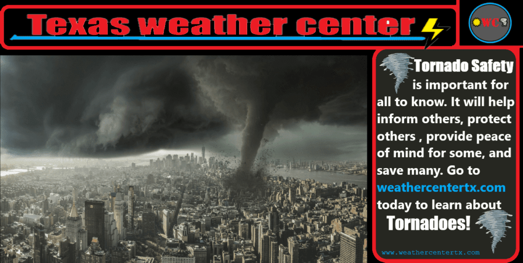
What is Tornado Safety
Tornado Safety Tips- how do you master staying safe when it comes to these monsters of nature? Take this course and just 10 minutes later you will know so much more and feel much less fear and much more confidence that YOU can stay safe from tornadoes. Want to know what the layout is? Check it out here:
If you wish to skip directly to the “Basic Safety Tips on Tornadoes” section because you want to skip the fundamentals for some reason, go to section 7.
- Why is it Important to Learn This?
- What is a Tornado?
- How does a Tornado Form?
- Ways to Determine Tornado Formation
- How to Read a Weather Radar
- Types of Weather Warnings and Weather Terms
- Basic Safety Tips on Tornadoes
- Storm Preparation
- Good External Resources
- Advanced Tips and Closings
- How to Report Storms
Why is it Important to Learn This?
In Texas, we all know what tornadoes are capable of — just look at the news! Here, you can learn what tornadoes are, what destruction they can cause, how to prepare for a tornado, how to properly execute tornado safety, what warnings and watches are, what to do during a tornado, where to be during a tornado, and what to do after a tornado! All of your questions answered here! The time is now to learn about this; later may be too late.
-What you can get out of this after the read-
• Be confident and prepared when storms come
• Have a “Tornado Plan” set up with your family
• Know your safe place
• Be so knowledgeable on tornadoes so that you can “wow” your friends with facts!
What is a Tornado?
A tornado is a mobile, destructive vortex of violently rotating winds having the appearance of a funnel-shaped cloud. tornadoes form under a wall cloud under certain conditions. Moisture, wind shear, and temperature all come into consideration when tornadoes try to form in a supercell thunderstorms. A more simple definition of a tornado is a violently rotating column of air that extends down from a thunderstorm. Tornadoes, while most only last a few minutes, some can cause catastrophic damage very quickly in a localized area over a path of several miles. Go to the “Basic Safety Tips” section to see many important resources and also the “Good Resources” section to see the worst US tornadoes, some very interesting statistics, and outside source research.
-Where do Tornadoes Occur?-
Tornadoes happen all around the world. The most common area to find tornadoes is in the US with over 1,200 tornadoes on average a year. Keep in mind that tornado records and severe weather records only go back to the mid 1900’s, so any tornadoes before then could not get averaged up into this final number. So the US by far gets the most tornadoes per year. The second most common areas to find tornadoes in is Bangladesh and Argentina.
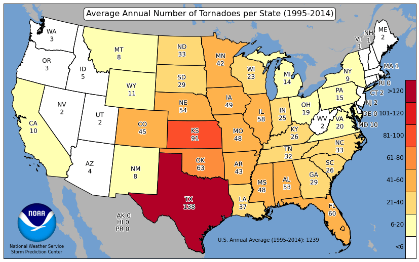
Over 1,200 Tornadoes are recorded in the US every year
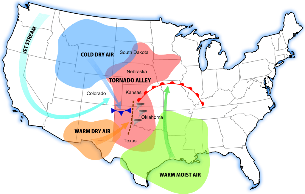
-Where is Tornado Alley?-
Tornado Alley is constantly changing as forecasting and tornado research improves. The Tornado Alley is a zone of area that signifies the highest risk and most frequent number of tornadoes. Anyone in this area should be aware of storms especially since the conditions are usually more favorable for tornadoes in this region rather than in others. Of course tornadoes still occur outside Tornado Alley but less often as records show. It is rare to see
tornadoes on the coasts of America and it is most rare to see a tornado in California or Alaska.
-What is the Enhanced Fujita Scale?-
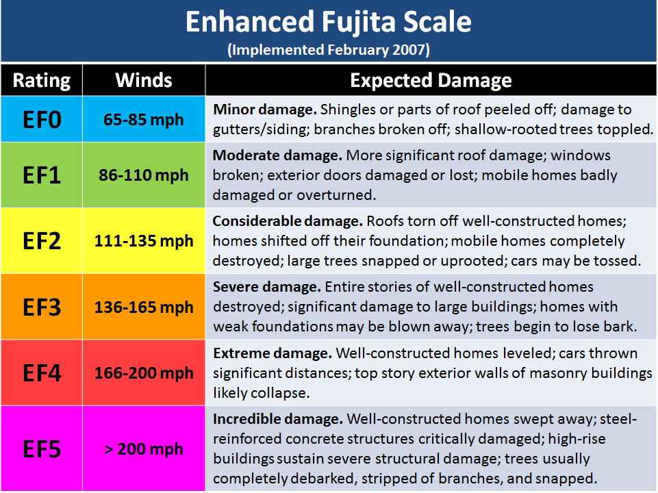
The Enhanced Fujita Scale is a rating scale for tornadoes ranging from EF0-EF5 and was made off of the original Fujita scale made in 1971. The EF scale was introduced not too long ago, in February of 2007. This scale tweaked the wind ratings a bit more from the last scale to align more accurately the with resulting damage done by wind from a tornado. This scale is usually abbreviated to “EF” and when you hear someone say “EF1 Tornado” you know they are talking about this scale and you can learn the scale here with this reference image to help you.
How does a Tornado Form?
Tornado History
Tornadoes have existed for as long earth has been around. Tornadoes appear in biblical writings as “whirlwinds.” Tornadoes have also been referenced by the Greek philosopher Aristotle in 4th century B.C. Unfortunately, back then, many believed severe storms and tornadoes were just their gods punishing them and that they controlled these. But, in reality and with all the modern technology, we have seen just how amazing yet complex the structure and design of a tornado really is. In the 1950’s the term tornado was just coming about. This was because before then meteorologists were forbidden to use the word “tornado” because they had no scientific explanation for such storms so they assumed it must be “dark” or “cursed” and must not be talked about. Now, in the 1950’s as tech slowly increased, they had the beginnings of instruments to gather data from storms and they began to learn more. They called tornadic storms “storm cyclones” and they called tornadoes “tornado cyclone.” Then in 1957 Theodore Fujita identified parts of a storm and proposed the first workable storm structure model that explained tornado and storm development. This gave way to the development of the “Fujita Scale” by him in 1971. Then finally in the 1970’s a supercell was defined as a separate storm type. This was confirmed just a year or two later as the Doppler Radar came out. Just look at the progression of technology we have now just in the past 50 years!
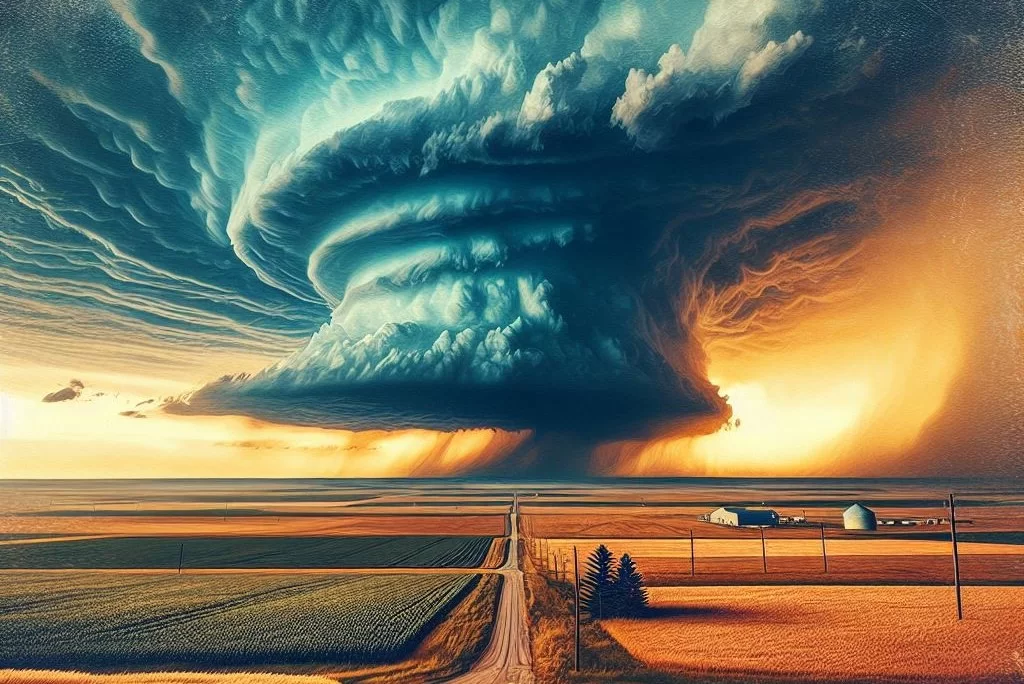
Tornado Formation
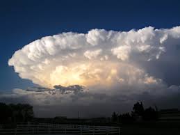
The basics of a tornado’s formation begins with the typical elements needed for storm development. Once the storm has formed, the element that really grows the storm ‘upward” is the warm, convective, moist, spring/summer air. Remember, whenever you see a cloud grow UPWARDS with towering columns, or even an “anvil-shaped” top, those are signs of a strong developing storm. Next, the storm could get the characteristics of a mesocyclone storm. A mesocyclone is formed when a strong updraft flows into a storm (all strong storms have one) and it meets with upper level winds. This is known as wind shear. Think of three air streams of wind flowing horizontally: One at 10,000 ft, the other at 20,000 ft, and the last at 30,000 ft. When you have a storm growing upwards (updraft winds with it), the updraft vertical winds will interfere with those horizontal winds more and more the higher the storm grows. This will form a rotating funnel within the storm. Back down on the surface, you may notice a wall cloud or a funnel if conditions are right. After, a tornado will potentially form. Just remember that a mesocyclone is one of the most important parts of a severe thunderstorm.
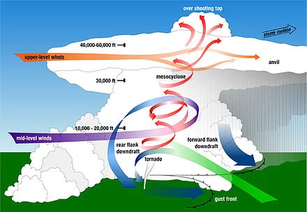
Tornadoes most often occur between 4-9 PM. When you notice these key characteristics in the sky, know a tornado may be near:
• Rotation: the clouds or a cloud deck is visibly rotating. It won’t be hard to tell. If you’re squinting to see if it really is, then it’s probably not a big deal. Real rotation is quite frightening and you should notice it immediately if you are looking. Seek shelter immediately.
• Greenish sky: this indicates that the storm may contain a lot of hail. This happens because ice crystals scatter the light around them and when you have blue light from water and a golden light from the sun, it can create a greenish tint in the clouds. This often signifies a tornadoes production may be close because large hail can be associated with supercell storms and what also comes with supercell storms? Tornadoes
-Types of Tornadoes-
There are many types of tornadoes such as cigar tornadoes, spiral tornadoes, cylinder tornadoes, etc. Here we will just go over the most common three:
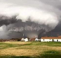
Wedge Tornado
A very large, wide tornado that commonly looks like this (pictured). V shape tornadoes are similar, but begin with a wide top but slim out as you go toward the bottom of the twister.
Rain-wrapped Tornado
A tornado which is obscured by a rain filled base (near the downdraft of the storm). This is when the tornado is virtually impossible to see to the naked eye because rain blocks out the structure. This can be very dangerous since this causes many to believe that “there is no tornado nearby” when in reality … there is.
Rope Tornado
A tornado that is very thin and usually moves much more violently through the air. This typically signifies a weaker tornado but not always. Look up pictures of rope tornadoes to see their eerie shapes!
-The 4 Types of Thunderstorms-
Supercell — A system producing severe thunderstorms and featuring rotating winds sustained by a prolonged updraft that may result in hail or tornadoes. A supercell also features a mesocyclone – a deep, persistently rotating updraft. For this reason, these storms are sometimes referred to as rotating thunderstorms. These last around 2-4 hours.
Single-Cell Thunderstorm — These storms may be powerful but usually only produce heavy rain and lightning. They typically don’t have enough energy to produce severe weather or have strong updrafts.
Squall Line — A strong line of thunderstorms that forms along or just ahead of an advancing cold front. These storms move very quickly usually causing widespread wind damage and potential for tornadoes. These storms are able to travel for hundreds of miles and can stretch over 1,000 miles length wise (from top to bottom)!
Multi-Cell Thunderstorm — A thunderstorm with many different sections and cells within it. They typically have many anvil heads and can get to be very strong storms. Multi-cells each have life cycles and stages within them. Growing, Mature, and Dissipating stages. Each cell can be at different stages at different times which means parts of the storm will be stronger or weaker than other parts.
Ways to Determine Tornado Formation
This section is extremely important especially for those who would like to understand weather better in terms of severe storms but also for those who work outdoors often for their job and need to be safe when it comes to weather.
–Hook Echo on Radar–
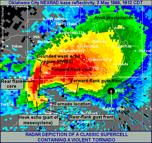
A Hook Echo is an appendage or hook shaped object on radar imagery. As you can see in the image on the left of the two, there is a well defined hook. This appears this way because of the shape of a thunderstorm. Remember the diagram of a supercell? There is like a cove in the storm where the inflow air comes in which creates a hook-like appearance. Strong inflows like that are almost always associated with a tornado at some point. When you see a hook you could also be seeing a debris field which could very well be seen with a sensitive enough radar. One key forecasting tool for tracking tornadic storms is something called velocity. Read more about velocity HERE
-Clouds-
Many clouds are associated with severe thunderstorms and pre-tornado birth. Below will be a simple list of them. Find the definitions under the “Weather Terms” section.
Wall Clouds are associated with tornadoes. These clouds lower themselves from the main deck of clouds and usually rotate and appear as rugged, sometimes circular, clouds that most tornadoes end up descending from. *Note- Shelf clouds look similar in a way but are in no way related or the same!*
Funnel Clouds are rotating columns of air that have not made contact with the ground. Many still think of these as tornadoes but really they aren’t — they are just the stage right before a tornado. Not all funnels become tornadoes!
-Weather Alerts-
Weather Alerts are very important for updating you on the latest severe weather in your area. Without NOAA, NWS, and other weather organizations, many more lives would have been lost. Make sure you are receiving weather alerts today! *Note- most phones now automatically receive government issued weather alerts (NWS)*
-Outdoor Warning Sirens-
Boy are these sometimes scary but so helpful! Whenever a tornado or severe thunderstorm is in the area (varies for each city), the city will sound its weather siren which means take shelter immediately! Unfortunately many still do not heed the warning… this results in sometimes travel accidents and deaths due to severe weather.
Remember to Share this Blog with everyone you know and spread the word about WC! This article could save lives! Include the image as promotional product!
Tornado Safety Tips
How to Read a Weather Radar
Why is this important? Because it helps people in general become a little more self reliant so they can understand what storms may come while still listening to weather alerts and local news stations. Many weather radars nowadays are fairly simple to use and understand, but some are more professional. For your simple weather radar phone app, it is important to understand 3 things:
- Future Radars are not as accurate as many think. Unfortunately there is sometimes erratic data and predictions that just dodn’t end up happening and could mislead others when looking at radar. The most accurate future weather data in my opinion is going to be weather models from either Pivotal Weather or NWS.
- Understand the legend. This is your map legend and key for the radar map. Most radar colors go from light green to pink for rain and blue and pink for wintery precipitation. Pink in a storm of rain is usually hail (more detailed radars allow examination on hail cores).
- A storm’s movement. Track the storm’s movement by looking at the past radar to help gauge the movement of the storm or use the future radar as a reference. Doing this helps pin down more specific location details for who gets what.
-What is a Doppler Radar?-
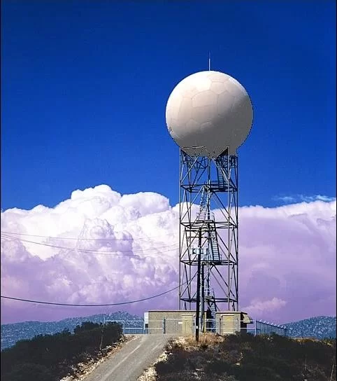
A type of Radar that is capable of locating a storm, detecting its motion, and detecting the precipitation type through waves and pulses that are sent out of a device that looks most like the image attached. Most major weather stations and NWS stations have these. They are expensive but also some of the most accurate weather radars.
View some good weather radars here
View some great recommended weather apps here
Types of Weather Warnings and Weather Terms
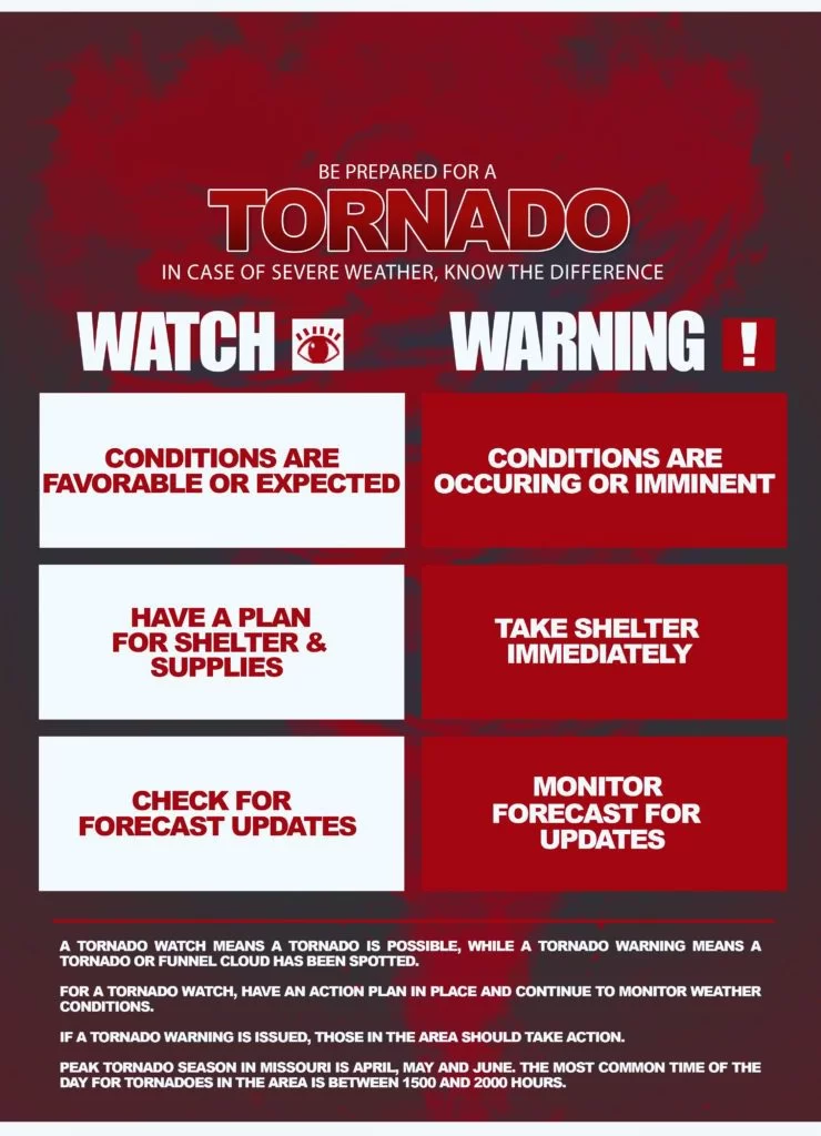
A TORNADO:
WATCH — is when conditions are favorable for tornado development.
WARNING — is when a funnel cloud has been spotted.
Take BOTH weather warnings seriously! With a watch just prepare and stay weather aware, but a WARNING requires immediate reaction and no delay! These warnings may only provide a couple minutes of notice before a tornado hits your area!

-Weather Terms-
Wall Cloud — A wall cloud is a large, localized, persistent, and often abrupt lowering of cloud that develops beneath the surrounding base of a cumulonimbus cloud and from which tornadoes sometimes form. It is typically beneath the rain-free base portion of a thunderstorm, and indicates the area of the strongest updraft within a storm.
Enhanced Fujita Scale — The Enhanced Fujita scale (or abbreviated as EF-Scale) rates the intensity of tornadoes in some countries, including the United States and Canada, based on the damage they cause.
Tornado Emergency — A tornado emergency is an enhanced version of a tornado warning, which is used by the National Weather Service (NWS) in the United States during imminent, significant tornado occurrences in highly populated areas. Although it is not a new warning type from the NWS, issued instead within a severe weather statement or in the initial tornado warning, a tornado emergency generally means that significant, widespread damage is expected to occur and a high likelihood of numerous fatalities is expected with a large, strong to violent tornado.
Tornado — A tornado is a violently rotating column of air that is in contact with both the surface of the Earth and a cumulonimbus cloud or, in rare cases, the base of a cumulus cloud. The windstorm is often referred to as a twister, whirlwind or cyclone, although the word cyclone is used in meteorology to name a weather system with a low-pressure area in the center around which, from an observer looking down toward the surface of the earth, winds blow counterclockwise in the Northern Hemisphere and clockwise in the Southern. Tornadoes come in many shapes and sizes, and they are often visible in the form of a condensation funnel originating from the base of a cumulonimbus cloud, with a cloud of rotating debris and dust beneath it.
Supercell — A system producing severe thunderstorms and featuring rotating winds sustained by a prolonged updraft that may result in hail or tornadoes. Characterized by the presence of a mesocyclone: a deep, persistently rotating updraft. For this reason, these storms are sometimes referred to as rotating thunderstorms. Lasts around 2-4 hours
All terms from Wikipedia
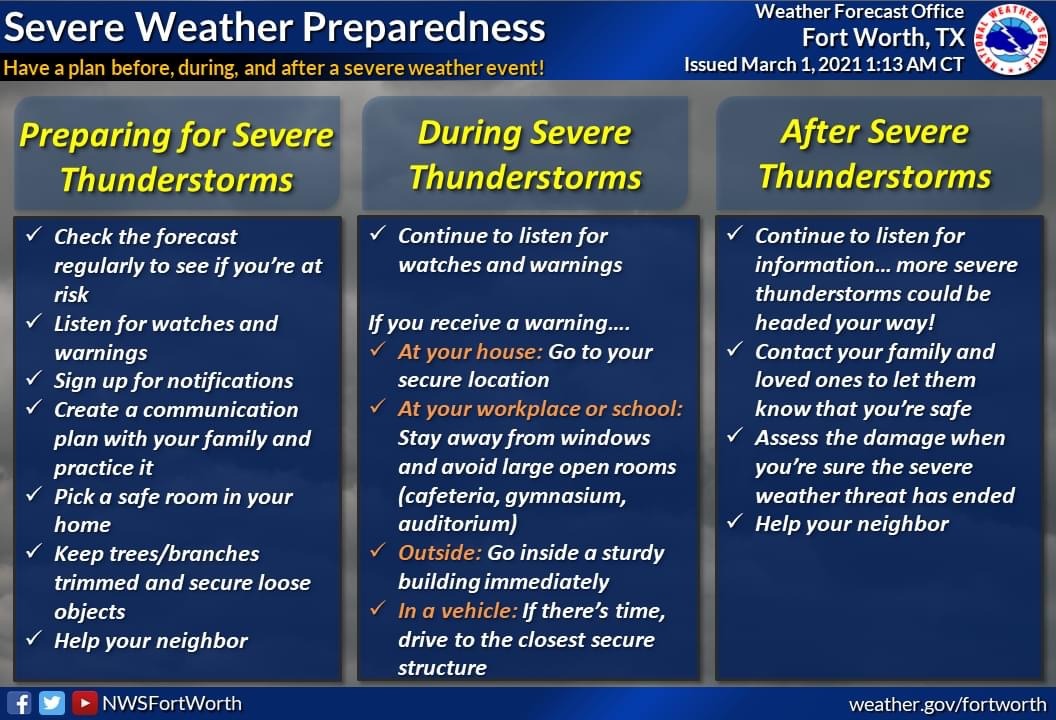
Basic Safety Tips on Tornadoes
First things first. Let’s remember why it’s important to learn about this.
In Texas, we all know what tornadoes are capable of doing. Just look at the news! Here, you can learn what tornadoes are, what destruction they can cause, how to prepare for a tornado, how to properly execute tornado safety, what warnings and watches are, what to do during a tornado, where to be during a tornado, and what to do after a tornado! In Texas, tornadoes are a problem, just like earthquakes are the problem for California and Tsunamis for Japan. Again there are over 1,200 tornadoes recorded every year on average in the US, about 145 of those recorded in Texas on average, and with about 8 deaths on average with ten’s of injuries.
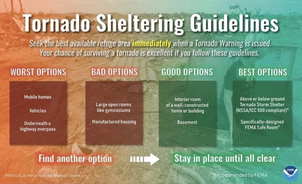
Now to the Tornado Safety. Here (pictured) is a great reference image to look at with regards to sheltering from tornadoes. With that image, we also need to cover 2 main points. “When is it time?” and “Where is shelter?”
-When is it Time?-
When is it time to hide and take shelter in the safe room?
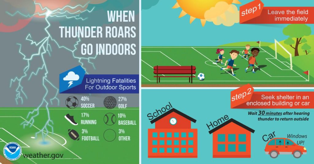
First, you should be already inside during a storm. “When Thunder Roars, Go Indoors!”
Second, when you hear that weather siren, get your stuff and go STRAIGHT to your safe room. No photo snapping, tornado selfies, texting of friends saying “TORNADO!”… no … get to your safe room with your supplies that you should have in there beforehand, hunker down, turn on a radio, and then conserve device power as much as possible just in case of power loss.
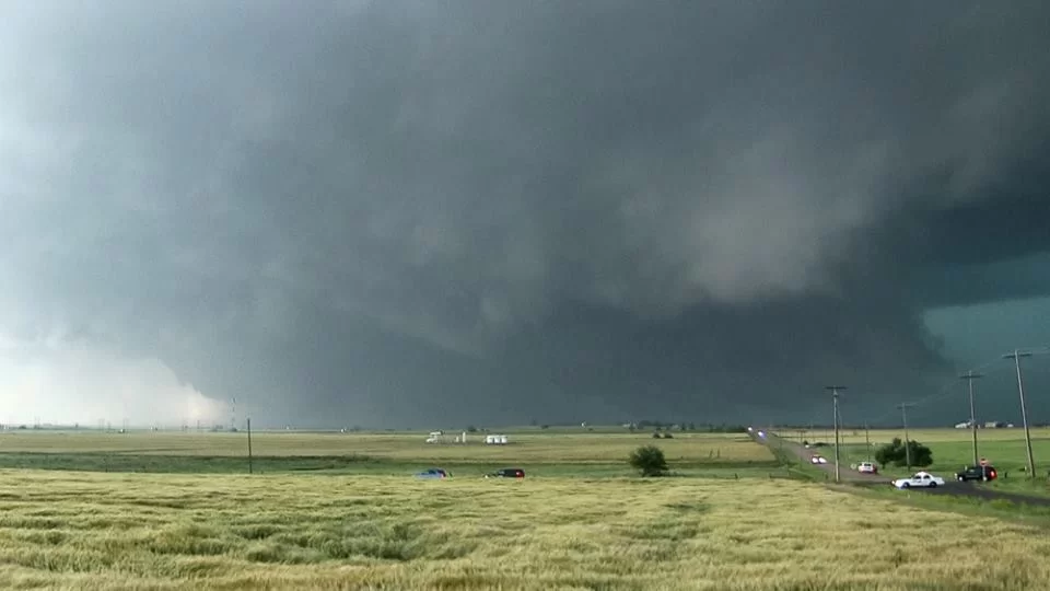
More specifically, when is it time though even before the siren sounds? If you see:
- Rotation outside
- Catch the local news of radar showing your area in imminent danger
- You are under a Tornado Warning
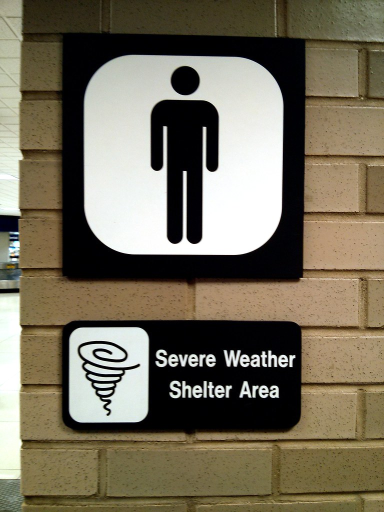
-Where is Shelter?-
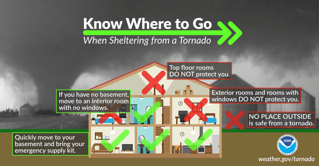
House
What is the most interior room in your house? Found one? Good. Make sure it doesn’t have a:
- Skylight
- Tented roof
- Any other structural weakness
Can’t find one? Go for second best.
Apartment or Mobile Home
Go to the bottom floor of your apartment and take shelter there. If in a mobile home, find a FEMA shelter or dedicated storm shelter in the area (there usually is one in mobile home neighborhoods).
On the Road
On the road and see a tornado? You automatically find yourself in a bad situation. It may have been prevented with a quick check of the forecast or a check at the severe weather potential in your area for that day. But many still have work and have no choice sometimes. Here’s what to do:
Find a place to stop like a strong building or large windowless building. Buildings with tons of windows are really bad places to be. If you are in the country, get out of your car and lay down flat in a ditch. Doesn’t sound safe but it is safer than staying in a car or even UNDER your car… Let’s make this a little clearer…
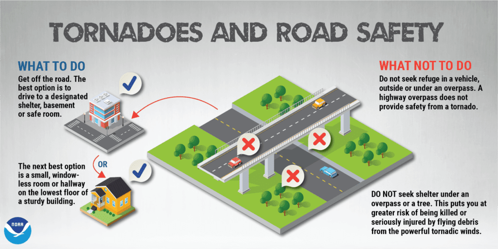
What to NOT do when in your car during a Tornado:
- Stay in your car or under your car… Remember that cars are death traps. Cars only weigh about a 3rd of a ton. Tornadoes find that light and would most likely pick your vehicle up and toss it. Too many deaths by tornadoes have been associated to deaths in vehicles. Find a ditch, lay down face flat, and cover your head with your hands.
- Try to outdrive the tornado… Most of the time trying to outdrive a tornado is a poor choice. Tornadoes can travel at 50-60 mph sometimes and would be a losing battle to outdrive most of the time.
- Get out and watch the tornado… Kind of understood…
-What are the Dangers of Tornadoes?-
There are 2 major dangers with tornadoes. These are dangers that you are able to protect yourself from.
- Strong Winds: Every tornado has 3 types of winds: horizontal winds, updraft winds, and rotating winds. Horizontal winds cause trees to flatten, shingles to tear off roof tops, and fences to be blown down. Updraft winds cause cars to be lifted up into the air, trees to be uprooted, and roofs lifted up out of their place. Rotating winds cause debris fields, shrapnel clouds, and many more things. To stay safe from strong winds, seek shelter when warnings are issued and remain in interior rooms of your secure structure with no windows around.
- Debris fields: This is the flying debris that is usually always inside a tornado and around it. These objects could be anything from two-by-four’s to cars flying around in the twister. All objects could be very lethal if one were to hit you. To stay safe from debris fields, remain in shelter and in interior rooms away from all windows during a tornado. Also grab a mattress, bike helmets, or blankets to help protect yourself from falling debris, shrapnel, glass shards, and wind splinters if your home were to get hit.
Storm Preparation
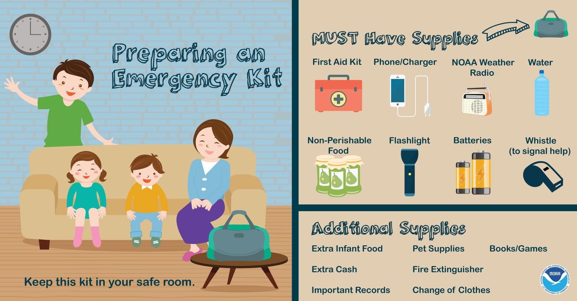
When the time comes, it’s not only important to be prepared mentally for WHAT to do, and WHEN to do it, but also have the SUPPLIES needed to execute it.
Supplies you want to have handy:
Helmets, pillows, or mattresses can act as coverings from debris if a tornado should hit. Be prepared. Shoes, first aid, flashlights, whistles, pet supplies, emergency radio, your mobile devices… all of these are important to have in your safe room.
Similar to the supplies you want to have for when a hurricane hits… (you can learn about Hurricane Safety here) you want to have a kit ready for when severe weather season starts. Preferably, keep the kit in your safe place so when a storm hits you can have it all ready to go.
Home protection
There is not much you can do during an impending destructive disaster for your home, but beforehand, you can prepare like getting the necessary supplies, insurance, etc.
Make sure before a tornado hits to:
- Shut windows
- Close blinds
- Park vehicles inside your garage if possible
- Close all doors, grab pets, and grab most important belongings
Storm Shelters Save Lives!
Good External Resources
We are almost done here! But I know your going to want to explore more, so I’m going to tell you:
Want more Info?
Want more data?
Want to know ways to track Weather?
-Storm Chasers!-
These people are truly fearless, I tell you. They go into the heart of some storms and take some of the most spectacular weather photos you will ever see. Follow Texas Storm Chasers on their website to see their great blogs about chasing and see their awesome storm chasing footage and coverage whenever there is a storm in the Texas area!
“Largest Tornadoes in the World“
What is the largest tornado EVER recorded? It is the El Reno tornado of course! In the early evening of Friday, May 31, 2013, a very large and powerful tornado spawned over rural fields of Central Oklahoma. The tornado rapidly strengthened growing to a whopping 2.6 miles wide with 302 mph winds within the vortex, making it the widest and most intense tornado ever to have existed in all the world. Just look at the images! After making its trek over 16.3 miles of land damaging almost no structures, it finally weakened. Unfortunately there were 8 casualties, 3 of which were storm chasers including the highly respected Tim Samaras and Paul Samaras from the TWISTEX Team.
Massive tornadoes cause a massive amount of force to the earth almost like an earthquake. The force is equivalent to 100 pounds of TNT per second! These monsters are most common in places in Oklahoma, northern Texas, and the Texas panhandle area closer to Oklahoma. Want to learn more? See the most monster tornadoes in history here! Major US Tornadoes
Advanced Tips and Closings
So this concludes the Tornado Safety Tips course! I hope you all enjoyed and of course make sure to share this with your friends and family so others can learn about tornadoes and how to stay safe too! I highly encourage you all to follow the links I posted on this page and also to more external research!
Media
How to Report Storms
Want to become a part of Weather Center? Join our Storm Reporter Team! Here you can report storm conditions in your area directly to WC for free! Sign up today to get started!
WC Code:
WC2021TORNADOES
Remember to share this blog with your friends today!
Learn More Weather 101!
Types of Weather Section was made to inform viewers about all forms of severe weather that may be experienced or discussed about in WC posts! Here you can become weather aware and feel more prepared for severe weather! Each section includes details, graphics, videos, and resources to help the reader fully grasp the information given to them. Read more today!
[jp_post_view]