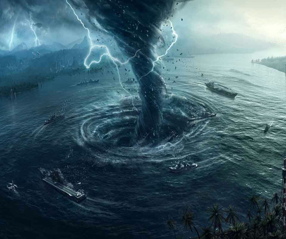
Hurricanes are fierce and destructive. They are no joke. When it comes to hurricanes, we must take all of it seriously, because millions of lives in their paths are at stake. If it wasn’t for the amazing technology we have this day and age for tracking them, things would be much worse. Still, we must learn more about them and know what to do. Knowing your Hurricane Safety Tips is very important.
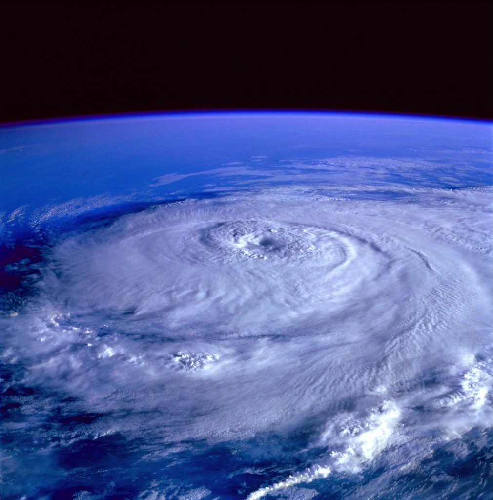
A hurricane is a very large storm! It can be up to 600 miles across and have strong winds spiraling inward and wind speeds of 75 to 200 mph! Each hurricane can last for about a week or so moving 10-20 miles per hour over the open ocean. Hurricanes get stronger by gathering hear from the ocean moisture and grow from first Tropical disturbances to Tropical Depressions to Tropical Storms to then finally Hurricanes. Hurricanes rotate in a counter-clockwise direction around an “eye” in the Northern Hemisphere and clockwise direction in the Southern Hemisphere. The center of the storm is called the eye of the storm and it is the calmest part. In fact, you could get a sunburn in the eye of the hurricane but then 20 minutes later be facing 150 mph winds and tons of rain!
Tropical Disturbance: A cluster of weak storms that have gathered together and have shown to be strengthening. In order to become a Tropical Disturbance they need to show that their pressure (mbs) is decreasing and that the storm is intensifying.
Tropical Depression: A strong cluster of storms that have gathered together into a larger more dense cluster of storms that actually are beginning to rotate very slightly and their winds have picked up to about 40 mph. The storm is increasing in strength and growing in size.
Tropical Storm: Now the storm has actually formed into one rotating storm producing winds up to 73 mph and larger waves with and ever so decreasing pressure. The storm could be continuing to strengthen and NHC (National Hurricane Center) could send out warnings on coastal regions for this kind of storm. The eye is still usually not visible in a tropical storm.
Hurricane: Now it is a large rotating storm with high speed winds that forms over warm waters in tropical areas. Hurricanes have sustained winds of at least 74 miles per hour and an area of low air pressure in the center called the eye. The scientific name for a hurricane is a tropical cyclone. Hurricanes weaken when entering areas of high pressure. Hurricanes are most destructive with how they carry in 5-15 feet of water (called storm surge) from the ocean and flood the coasts. The eye is usually visible and hurricanes can grow up to CAT 5 before weakening. Average lifespan is about 7 days. About 10 for the whole process.
Why Learn about This?
Hurricanes are considered the largest storm systems on planet earth and the most destructive in most cases. Hurricanes are monsters and we must learn how to beat the storm. Here, you can learn what Hurricanes are, what destruction they can cause, what categories there are, how to prepare for one, what warnings and watches are you should watch out for, What things you should know before hurricane season, what to do if you are told to evacuate, what to do if you live in a hurricanes presumed path, and what to do after a hurricane and how to recover from it. The time is now to know about it, later may be too late. Even if you don’t live on coastal regions, your friends and family may. Knowing what to do could save lives.
How do you measure Hurricane Strength?
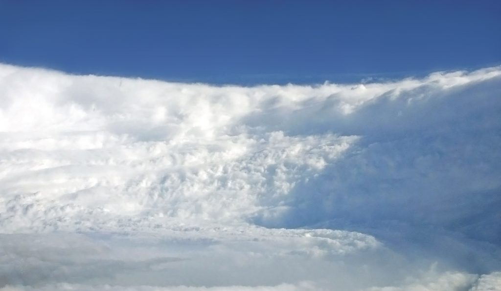
The Hurricane Structure is shown above. Hurricanes are destructive and massive storms. Their Outflow Cirrus shield can sometimes stretch over 300 miles in diameter. Basically warm moist air from the ocean will be sucked inward and up into the eye of the storm, almost as a tornado would do. Then the outflow air will surface and flatten upon the tops of the cirrus shield. The same happens in small scale with the rain bands that end up forming cavities in the actually storm structure. These monsters rotates counterclockwise in the northern hemisphere. Their catagories or strength rating (Saffir-Simpson Hurricane Wind Scale) are listed below:
Image: NOAA and NHC
Hurricanes can upgrade strength quickly, sometimes once or even twice in just a 24 hour period. Hurricanes have left families homeless and have impacted 100’s of millions over all of history. The most destructive and most famous Hurricanes are listed in a NHC article “Hurricanes in History“.
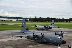
So to answer how meteorologists know that a hurricane has “upgraded”, well they have many buoys in the ocean that measure wind speeds, they have special scientists called Hurricane Hunters that fly in super planes built to survive hurricanes. They get readings and provide info about the hurricane and the eye of it. Here are some here:
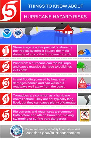
Hurricanes can devastate cities and leave entire towns under water or torn apart. The biggest factors of hurricane destruction are:
The Wind:Hurricanes and other ocean storms can cause destructive winds with gusts up to 200 mph sometimes. These winds can knock over buildings, fling cars, and cause mayhem.
The Storm Surge:Hurricanes and other ocean storms can cause storm surge (and inflow of extra water pushed in by the hurricane onto the land) that can reach up to 14 feet or more! Typically around 2-6 feet of storm surge. Large hurricanes cause more.
The Rain:Hurricanes and other ocean storms can cause tremendous rainfall for many days on end. Totals can reach up to 24 to 36 inches of rain… or even more! That’s a lot on top of the storm surge as well! Typically the rainfall is around 6-12 inches.
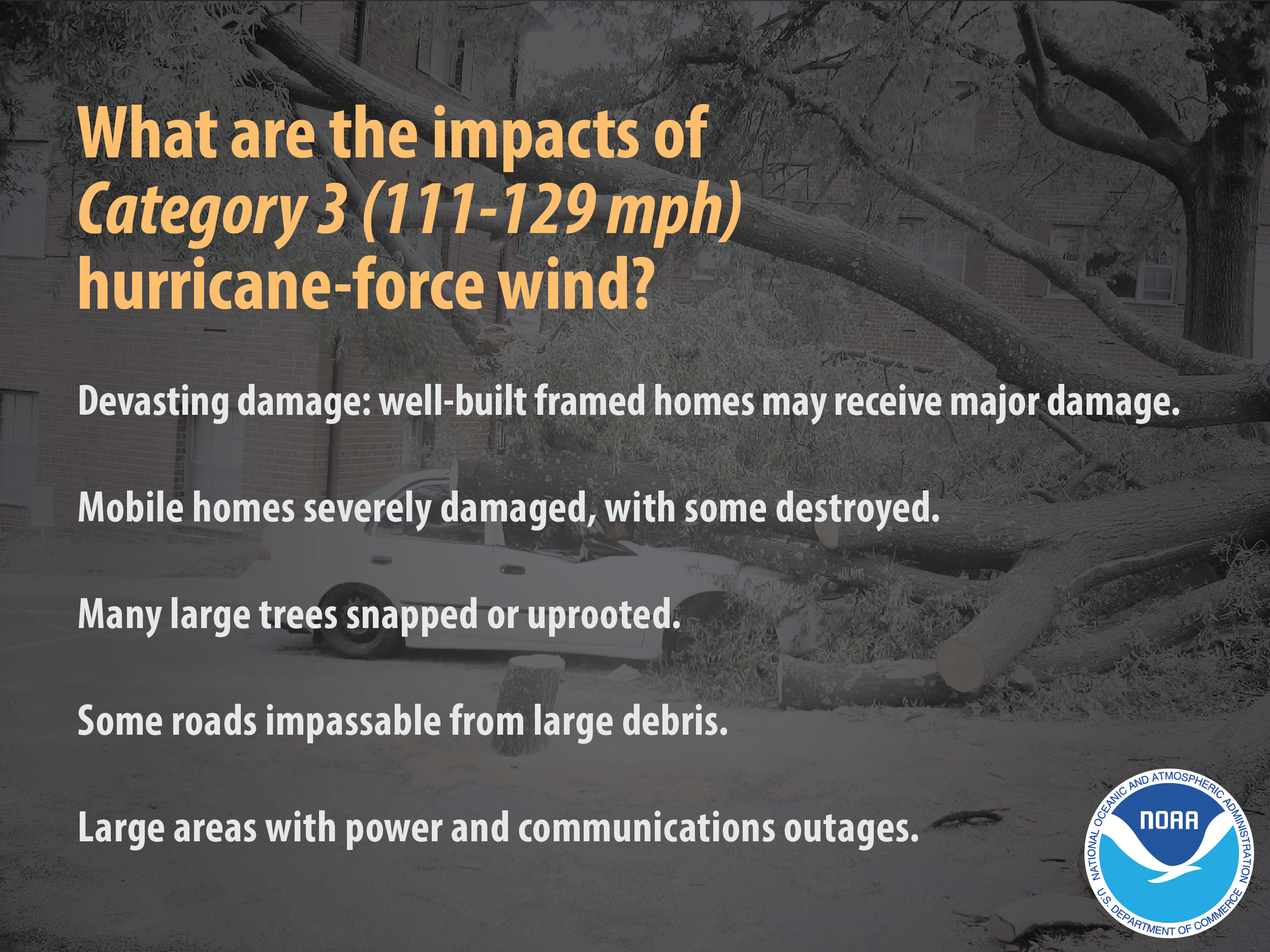
Cat 3
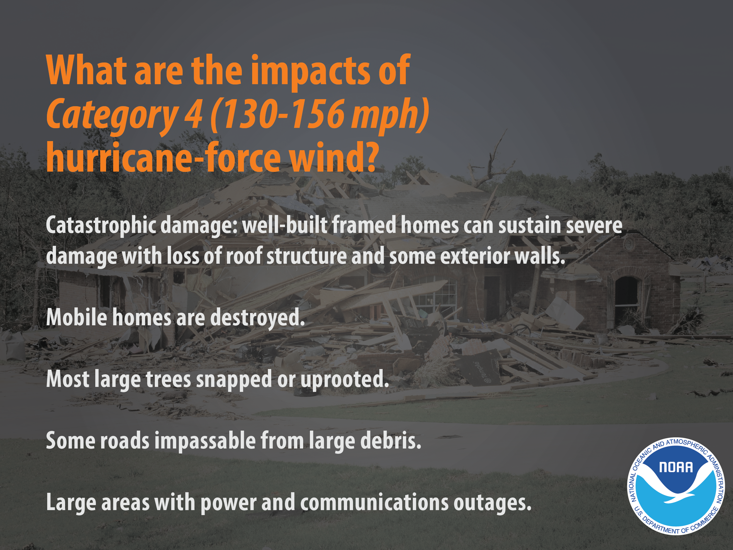
Cat 4
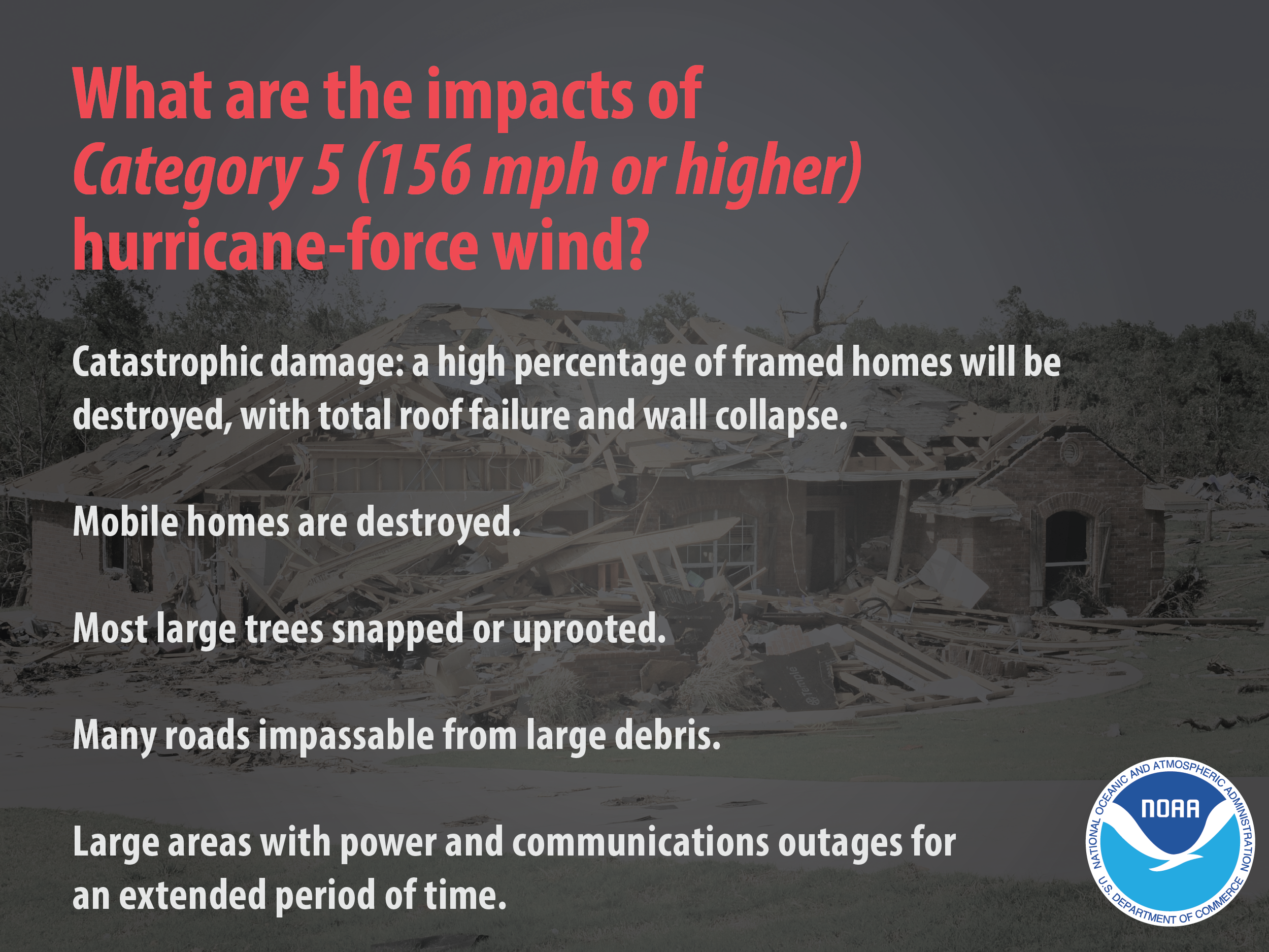
Cat 5
4. Why be prepared?
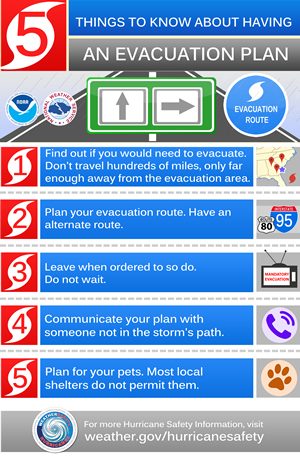
Preparing for an event such as a hurricane, natural disaster, or even tornadoes could save your life and others. Being prepared by either doing drills, have a kit prepared for any natural disaster, having a “Safe Place” during times of emergency, and for hurricanes — have a evacuation route and plan with a safety kit. It is important to know what to do BEFORE because trying to figure it out DURING may be impossible. Knowing what hurricane warnings are, what hurricane stages are and how close they have to be to start impacting the coast, or what to do during hurricanes are just a few of the things that us and the community need to know to insure safety and efficiency during a disaster.
How to prepare for Hurricane.
“Prepare now, not during”
It’s important! Let’s now learn about how to prepare for one of these hurricanes. Here we will discuss a hypothetical hurricane and simulate it. Next we will then talk about hurricane prep along a timeline…. so let’s get into it:
We will create a made up scenario of a hurricane in the Atlantic moving North West toward the Gulf of Mexico. Let’s say you live in Galveston Texas on the coast.
July 17th, 8:00 AM | 🌀96 hours from coast
You notice that the National Hurricane Center has confirmed a tropical disturbance 294 miles off the coast and is moving very slowly at only 3 MPH N/NW. At this time you should:
Make sure you know evacuation plans just in case you need to evacuate.
Make sure you know what to do during a hurricane. Practice with your family and friends to prepare and review all scenarios.
July 18th, 8:00 AM | 🌀72 hours from coast
You notice on the news that the storm has upgraded to a Tropical very weak tropical storm with the name Gusty which has winds around 50 MPH. It has covered distance and now is about 212 miles from the coast and moving at about 6 MPH N/NW. At this time you should:
Communicate with your friends and family and make sure they know what the forecast is for your given area.
Go out and stock up food just in case if it hits.
Make sure to frequently check NHC and your local news for updates.
July 19th, 8:00 AM | 🌀48 hours from coast
You see that Gusty has upgraded to a CAT 1 Hurricane with 76 MPH winds and continues to strengthen. NHC has issued a Hurricane Watch and Tropical Storm Watch ( See definitions below) for your location. The storm is approximately 113 miles from the coast slowing down slightly to 5 MPH moving N/NW. At this time you should:
Continue to check frequently for updates on the hurricane
July 19th, 8:00 PM | 🌀36 hours from coast
You see that Gusty is still a CAT 1 Hurricane with increasing winds. Tropical Storm Warning and Marine watches issued all over the area. 79 miles form the coast moving 3 MPH N/NW. At this time you should:
Turn on the TV or radio to your local station to get the latest updates and emergency responses.
Double check emergency supplies and kits
July 20th, 2:00 PM | 🌀18 hours from coast
You see that Gusty has upgraded to a CAT 2 Hurricane with still increasing winds with gusts up to 110 MPH. Hurricane Warnings and Red Flags are issued all around your area and the coastal regions. 59 miles from the coast moving at 4 MPH picking up speed. At this time you should:
Begin to finish the last things you have to do out and about as the rain bands and gusty winds could begin.
Continue checking for updates
Bookmark your city website on your mobile device to see updates as well
Bring outdoor furniture in, board up anything that needs to be boarded up (windows, etc.)
Check with friends and family and see how they are doing
Make sure your not required to evacuate. If told so, do it IMMEDIATELY.
July 20th, 10:00 PM | 🌀10 hours from coast
You see that Gusty is seemingly going to upgrade one last time to CAT 3 and cause over 140 MPH wind gusts. It is 35 miles from the coast slowing to a speed of 3 MPH moving NW. At this time you should:
Remain inside and safe
Make sure you are not required to evacuate one last time and check with friends and family and let them know where you are.
Stay away from windows and close windows and blinds
Turn Refrigerator and Freezer to the lowest temp and expect power outages for a long period of time.
Charge your devices and mobile devices to insure you still have communication just in case its an emergency.
Watch the news often to learn about the storm.
Go to a FEMA safe room, ICC 500 storm shelter, or an interior room for safety.
July 20th, 8:00 AM | 🌀LANDFALL
Hurricane Gusty hit Galveston TX as a Cat 3 with 155 MPH wind gusts and with over 7 feet of storm surge. At this time you should:
Remain inside and connected to news.
Check with your friends and family to see if they are okay.
If your house begins to flood, go to higher ground in the building. Do not climb into an attic or closed upper room.
Avoid windows
After the Storm:
Listen to authorities for information and special instruction.
Do not go outside and get trapped in high waters. Turn around, don’t drown.
Avoid electrical equipment or downed power lines.
Avoid debris or damaged buildings.
Check with friends and family to see if they are okay.
This is how you survive a Hurricane safely.
Definitions
All data from definitions below are from NWS
Hurricane Watch
A Hurricane Watch is issued when a tropical cyclone containing winds of 64 kt (74 mph) or higher poses a possible threat, generally within 48 hours. These winds may be accompanied by storm surge, coastal flooding, and/or river flooding. The watch does not mean that hurricane conditions will occur. It only means that these conditions are possible.
Hurricane Warning
is issued when sustained winds of 64 kt (74 mph) or higher associated with a tropical cyclone are expected in 36 hours or less. These winds may be accompanied by storm surge, coastal flooding, and/or river flooding. A hurricane warning can remain in effect when dangerously high water or a combination of dangerously high water and exceptionally high waves continue, even though winds may be less than hurricane force.
Hurricane Force Wind Warning
Hurricane Force
Wind Warnings are issued for the Tidal Potomac River and the Chesapeake
Bay when one or both of the following conditions is expected to begin
within 36 hours and not directly associated with a tropical cyclone:
1) sustained winds of 64 knots or greater
OR
2) frequent gusts (duration of two or more hours) of 64 knots or greater
Tropical Storm Watch
A Tropical Storm
Watch is issued when a tropical cyclone containing winds of 34 to 63 kt
(39 to 73 mph) or higher poses a possible threat, generally within 48
hours. These winds may be accompanied by storm surge, coastal flooding,
and/or river flooding.
The watch does not mean that tropical storm conditions will occur. It only means that these conditions are possible.
Tropical Storm Warning
A Tropical Storm
Warning is issued when sustained winds of 34 to 63 kt (39 to 73 mph) or
higher associated with a tropical cyclone are expected in 36 hours or
less. These winds may be accompanied by storm surge, coastal flooding,
and/or river flooding.
Coastal Flood Watch
A Coastal Flood Watch is issued
when moderate to major coastal flooding is possible. Such flooding
would potentially pose a serious risk to life and property.
Coastal Flood Watches are issued for coastal areas along the Tidal Potomac River and coastal areas along the Chesapeake Bay.
Coastal Flood Warning
A Coastal Flood
Warning is issued when moderate to major coastal flooding is occurring
or imminent. This flooding will pose a serious risk to life and
property.
Coastal Flood Warnings are issued for coastal areas along the Tidal Potomac River and areas along the Chesapeake Bay.
Coastal Flood Advisory
A Coastal Flood Advisory is issued when minor or nuisance coastal flooding is occurring or imminent.
Coastal Flood Advisories are issued for coastal areas along the Tidal Potomac River and areas along the Chesapeake Bay.
Flash Flood Watch
A Flash Flood
Watch is issued when conditions are favorable for flash flooding. It
does not mean that flash flooding will occur, but it is possible.
Flash Flood Warning
A Flash Flood Warning is issued when flash flooding is imminent or occurring.
Flood Watch
A Flood Watch is issued when conditions are favorable for flooding. It does not mean flooding will occur, but it is possible.
Flood Warning
A Flood Warning is issued when flooding is imminent or occurring.
So many are affected after a hurricane strikes. Billions of dollars of damage can be caused by the wind and flooding. Here are 3 ways to help the impacted.
Go to AMERICAN RED CROSS (https://www.redcross.org/) and donate to help hurricane clean up and relief!
Learn about hurricane safety and tell your friends about how to respond to prevent deaths and injuries.
Help in the clean up and disaster relief by going to the places impacted and volunteering.
What to get out of this
Staying safe during wild weather is important because sometimes forecasts are wrong and inaccurate . Remember these safety tips:
Know your Radar. Know what storms are around by simply checking WC’s radar or any reliable radar app or website like NOAA or MyRadar.
Prepare earlier rather than later. Never too sorry when you prepare rather than not and being in a dangerous spot.
Follow guidelines and warnings issued by NHC and NOAA or by your local government related to weather alerts.
Be safe, not sorry. 3 P’s = Predict, Prepare, protect.
Share this page with your friends to spread the word and protect others! Thank You!
Weather Center
Learn More Weather 101!
Types of Weather Section was made to inform viewers about all forms of severe weather that may be experienced or discussed about in WC posts! Here you can become weather aware and feel more prepared for severe weather! Each section includes details, graphics, videos, and resources to help the reader fully grasp the information given to them. Read more today!
Hurricanes are fierce and destructive. They are no joke. When it comes to hurricanes, we must take all of it seriously, because millions of lives in their paths are at stake. If it wasn’t for the amazing technology we have this day and age for tracking them, things would be much worse. Still, we must learn more about them and know what to do. Knowing your Hurricane Safety Tips is very important.
A hurricane is a very large storm! It can be up to 600 miles across and have strong winds spiraling inward and wind speeds of 75 to 200 mph! Each hurricane can last for about a week or so moving 10-20 miles per hour over the open ocean. Hurricanes get stronger by gathering hear from the ocean moisture and grow from first Tropical disturbances to Tropical Depressions to Tropical Storms to then finally Hurricanes. Hurricanes rotate in a counter-clockwise direction around an “eye” in the Northern Hemisphere and clockwise direction in the Southern Hemisphere. The center of the storm is called the eye of the storm and it is the calmest part. In fact, you could get a sunburn in the eye of the hurricane but then 20 minutes later be facing 150 mph winds and tons of rain!
Tropical Disturbance: A cluster of weak storms that have gathered together and have shown to be strengthening. In order to become a Tropical Disturbance they need to show that their pressure (mbs) is decreasing and that the storm is intensifying.
Tropical Depression: A strong cluster of storms that have gathered together into a larger more dense cluster of storms that actually are beginning to rotate very slightly and their winds have picked up to about 40 mph. The storm is increasing in strength and growing in size.
Tropical Storm: Now the storm has actually formed into one rotating storm producing winds up to 73 mph and larger waves with and ever so decreasing pressure. The storm could be continuing to strengthen and NHC (National Hurricane Center) could send out warnings on coastal regions for this kind of storm. The eye is still usually not visible in a tropical storm.
Hurricane: Now it is a large rotating storm with high speed winds that forms over warm waters in tropical areas. Hurricanes have sustained winds of at least 74 miles per hour and an area of low air pressure in the center called the eye. The scientific name for a hurricane is a tropical cyclone. Hurricanes weaken when entering areas of high pressure. Hurricanes are most destructive with how they carry in 5-15 feet of water (called storm surge) from the ocean and flood the coasts. The eye is usually visible and hurricanes can grow up to CAT 5 before weakening. Average lifespan is about 7 days. About 10 for the whole process.
Why Learn about This?
Hurricanes are considered the largest storm systems on planet earth and the most destructive in most cases. Hurricanes are monsters and we must learn how to beat the storm. Here, you can learn what Hurricanes are, what destruction they can cause, what categories there are, how to prepare for one, what warnings and watches are you should watch out for, What things you should know before hurricane season, what to do if you are told to evacuate, what to do if you live in a hurricanes presumed path, and what to do after a hurricane and how to recover from it. The time is now to know about it, later may be too late. Even if you don’t live on coastal regions, your friends and family may. Knowing what to do could save lives.
How do you measure Hurricane Strength?
The Hurricane Structure is shown above. Hurricanes are destructive and massive storms. Their Outflow Cirrus shield can sometimes stretch over 300 miles in diameter. Basically warm moist air from the ocean will be sucked inward and up into the eye of the storm, almost as a tornado would do. Then the outflow air will surface and flatten upon the tops of the cirrus shield. The same happens in small scale with the rain bands that end up forming cavities in the actually storm structure. These monsters rotates counterclockwise in the northern hemisphere. Their catagories or strength rating (Saffir-Simpson Hurricane Wind Scale) are listed below:
Image: NOAA and NHC
Hurricanes can upgrade strength quickly, sometimes once or even twice in just a 24 hour period. Hurricanes have left families homeless and have impacted 100’s of millions over all of history. The most destructive and most famous Hurricanes are listed in a NHC article “Hurricanes in History“.
So to answer how meteorologists know that a hurricane has “upgraded”, well they have many buoys in the ocean that measure wind speeds, they have special scientists called Hurricane Hunters that fly in super planes built to survive hurricanes. They get readings and provide info about the hurricane and the eye of it. Here are some here:
Hurricanes can devastate cities and leave entire towns under water or torn apart. The biggest factors of hurricane destruction are:
The Wind:Hurricanes and other ocean storms can cause destructive winds with gusts up to 200 mph sometimes. These winds can knock over buildings, fling cars, and cause mayhem.
The Storm Surge:Hurricanes and other ocean storms can cause storm surge (and inflow of extra water pushed in by the hurricane onto the land) that can reach up to 14 feet or more! Typically around 2-6 feet of storm surge. Large hurricanes cause more.
The Rain:Hurricanes and other ocean storms can cause tremendous rainfall for many days on end. Totals can reach up to 24 to 36 inches of rain… or even more! That’s a lot on top of the storm surge as well! Typically the rainfall is around 6-12 inches.
Cat 3
Cat 4
Cat 5
4. Why be prepared?
Preparing for an event such as a hurricane, natural disaster, or even tornadoes could save your life and others. Being prepared by either doing drills, have a kit prepared for any natural disaster, having a “Safe Place” during times of emergency, and for hurricanes — have a evacuation route and plan with a safety kit. It is important to know what to do BEFORE because trying to figure it out DURING may be impossible. Knowing what hurricane warnings are, what hurricane stages are and how close they have to be to start impacting the coast, or what to do during hurricanes are just a few of the things that us and the community need to know to insure safety and efficiency during a disaster.
How to prepare for Hurricane.
“Prepare now, not during”
It’s important! Let’s now learn about how to prepare for one of these hurricanes. Here we will discuss a hypothetical hurricane and simulate it. Next we will then talk about hurricane prep along a timeline…. so let’s get into it:
We will create a made up scenario of a hurricane in the Atlantic moving North West toward the Gulf of Mexico. Let’s say you live in Galveston Texas on the coast.
July 17th, 8:00 AM | 🌀96 hours from coast
You notice that the National Hurricane Center has confirmed a tropical disturbance 294 miles off the coast and is moving very slowly at only 3 MPH N/NW. At this time you should:
Make sure you know evacuation plans just in case you need to evacuate.
Make sure you know what to do during a hurricane. Practice with your family and friends to prepare and review all scenarios.
July 18th, 8:00 AM | 🌀72 hours from coast
You notice on the news that the storm has upgraded to a Tropical very weak tropical storm with the name Gusty which has winds around 50 MPH. It has covered distance and now is about 212 miles from the coast and moving at about 6 MPH N/NW. At this time you should:
Communicate with your friends and family and make sure they know what the forecast is for your given area.
Go out and stock up food just in case if it hits.
Make sure to frequently check NHC and your local news for updates.
July 19th, 8:00 AM | 🌀48 hours from coast
You see that Gusty has upgraded to a CAT 1 Hurricane with 76 MPH winds and continues to strengthen. NHC has issued a Hurricane Watch and Tropical Storm Watch ( See definitions below) for your location. The storm is approximately 113 miles from the coast slowing down slightly to 5 MPH moving N/NW. At this time you should:
Continue to check frequently for updates on the hurricane
July 19th, 8:00 PM | 🌀36 hours from coast
You see that Gusty is still a CAT 1 Hurricane with increasing winds. Tropical Storm Warning and Marine watches issued all over the area. 79 miles form the coast moving 3 MPH N/NW. At this time you should:
Turn on the TV or radio to your local station to get the latest updates and emergency responses.
Double check emergency supplies and kits
July 20th, 2:00 PM | 🌀18 hours from coast
You see that Gusty has upgraded to a CAT 2 Hurricane with still increasing winds with gusts up to 110 MPH. Hurricane Warnings and Red Flags are issued all around your area and the coastal regions. 59 miles from the coast moving at 4 MPH picking up speed. At this time you should:
Begin to finish the last things you have to do out and about as the rain bands and gusty winds could begin.
Continue checking for updates
Bookmark your city website on your mobile device to see updates as well
Bring outdoor furniture in, board up anything that needs to be boarded up (windows, etc.)
Check with friends and family and see how they are doing
Make sure your not required to evacuate. If told so, do it IMMEDIATELY.
July 20th, 10:00 PM | 🌀10 hours from coast
You see that Gusty is seemingly going to upgrade one last time to CAT 3 and cause over 140 MPH wind gusts. It is 35 miles from the coast slowing to a speed of 3 MPH moving NW. At this time you should:
Remain inside and safe
Make sure you are not required to evacuate one last time and check with friends and family and let them know where you are.
Stay away from windows and close windows and blinds
Turn Refrigerator and Freezer to the lowest temp and expect power outages for a long period of time.
Charge your devices and mobile devices to insure you still have communication just in case its an emergency.
Watch the news often to learn about the storm.
Go to a FEMA safe room, ICC 500 storm shelter, or an interior room for safety.
July 20th, 8:00 AM | 🌀LANDFALL
Hurricane Gusty hit Galveston TX as a Cat 3 with 155 MPH wind gusts and with over 7 feet of storm surge. At this time you should:
Remain inside and connected to news.
Check with your friends and family to see if they are okay.
If your house begins to flood, go to higher ground in the building. Do not climb into an attic or closed upper room.
Avoid windows
After the Storm:
Listen to authorities for information and special instruction.
Do not go outside and get trapped in high waters. Turn around, don’t drown.
Avoid electrical equipment or downed power lines.
Avoid debris or damaged buildings.
Check with friends and family to see if they are okay.
This is how you survive a Hurricane safely.
Definitions
All data from definitions below are from NWS
Hurricane Watch
A Hurricane Watch is issued when a tropical cyclone containing winds of 64 kt (74 mph) or higher poses a possible threat, generally within 48 hours. These winds may be accompanied by storm surge, coastal flooding, and/or river flooding. The watch does not mean that hurricane conditions will occur. It only means that these conditions are possible.
Hurricane Warning
is issued when sustained winds of 64 kt (74 mph) or higher associated with a tropical cyclone are expected in 36 hours or less. These winds may be accompanied by storm surge, coastal flooding, and/or river flooding. A hurricane warning can remain in effect when dangerously high water or a combination of dangerously high water and exceptionally high waves continue, even though winds may be less than hurricane force.
Hurricane Force Wind Warning
Hurricane Force
Wind Warnings are issued for the Tidal Potomac River and the Chesapeake
Bay when one or both of the following conditions is expected to begin
within 36 hours and not directly associated with a tropical cyclone:
1) sustained winds of 64 knots or greater
OR
2) frequent gusts (duration of two or more hours) of 64 knots or greater
Tropical Storm Watch
A Tropical Storm
Watch is issued when a tropical cyclone containing winds of 34 to 63 kt
(39 to 73 mph) or higher poses a possible threat, generally within 48
hours. These winds may be accompanied by storm surge, coastal flooding,
and/or river flooding.
The watch does not mean that tropical storm conditions will occur. It only means that these conditions are possible.
Tropical Storm Warning
A Tropical Storm
Warning is issued when sustained winds of 34 to 63 kt (39 to 73 mph) or
higher associated with a tropical cyclone are expected in 36 hours or
less. These winds may be accompanied by storm surge, coastal flooding,
and/or river flooding.
Coastal Flood Watch
A Coastal Flood Watch is issued
when moderate to major coastal flooding is possible. Such flooding
would potentially pose a serious risk to life and property.
Coastal Flood Watches are issued for coastal areas along the Tidal Potomac River and coastal areas along the Chesapeake Bay.
Coastal Flood Warning
A Coastal Flood
Warning is issued when moderate to major coastal flooding is occurring
or imminent. This flooding will pose a serious risk to life and
property.
Coastal Flood Warnings are issued for coastal areas along the Tidal Potomac River and areas along the Chesapeake Bay.
Coastal Flood Advisory
A Coastal Flood Advisory is issued when minor or nuisance coastal flooding is occurring or imminent.
Coastal Flood Advisories are issued for coastal areas along the Tidal Potomac River and areas along the Chesapeake Bay.
Flash Flood Watch
A Flash Flood
Watch is issued when conditions are favorable for flash flooding. It
does not mean that flash flooding will occur, but it is possible.
Flash Flood Warning
A Flash Flood Warning is issued when flash flooding is imminent or occurring.
Flood Watch
A Flood Watch is issued when conditions are favorable for flooding. It does not mean flooding will occur, but it is possible.
Flood Warning
A Flood Warning is issued when flooding is imminent or occurring.
So many are affected after a hurricane strikes. Billions of dollars of damage can be caused by the wind and flooding. Here are 3 ways to help the impacted.
Go to AMERICAN RED CROSS (https://www.redcross.org/) and donate to help hurricane clean up and relief!
Learn about hurricane safety and tell your friends about how to respond to prevent deaths and injuries.
Help in the clean up and disaster relief by going to the places impacted and volunteering.
What to get out of this
Staying safe during wild weather is important because sometimes forecasts are wrong and inaccurate . Remember these safety tips:
Know your Radar. Know what storms are around by simply checking WC’s radar or any reliable radar app or website like NOAA or MyRadar.
Prepare earlier rather than later. Never too sorry when you prepare rather than not and being in a dangerous spot.
Follow guidelines and warnings issued by NHC and NOAA or by your local government related to weather alerts.
Be safe, not sorry. 3 P’s = Predict, Prepare, protect.
Share this page with your friends to spread the word and protect others! Thank You!
Weather Center
Learn More Weather 101!
Types of Weather Section was made to inform viewers about all forms of severe weather that may be experienced or discussed about in WC posts! Here you can become weather aware and feel more prepared for severe weather! Each section includes details, graphics, videos, and resources to help the reader fully grasp the information given to them. Read more today!