Storm Chasing is one of the world’s wildest hobbies. It is also one of the most dangerous. Storm chasing is a very dangerous job, but a very rewarding one for those who love weather. It comes with amazing sights, discoveries, and thrills. Read WC’s full 101 info page about everything on “storm chasing” to be prepared — whether you are a storm chaser yourself, a wanna-be, or just someone who desires to know about this wild hobby!
Storm Chasing is a very daring, exciting, and dangerous game of tracking storms. Many people enjoy watching storm chaser videos since they are often action packed and edited to show the best clips and captures, but that’s not the whole story. Here you can understand how chasing works, the risks, the adventure, and how to learn to storm chase yourself!
What is Storm Chasing?
Storm Chasing is simply the art and science of chasing a thunderstorm. It can be for any reason. While most storm chasers do what they do in the hopes of finding tornadoes, not all storm chasers chase for this reason. Some of the reasons can be for storm research, media broadcasting, photography, or just as a hobby. There are multiple reasons to chase and there is not necessarily a universal goal for every storm chaser. Here are some of the reasons:
You love weather! You are passionate about weather and storms and you want to join the action and see storms firsthand yourself. You can choose to pursue chasing all the way and chase the dangerous storms or you may choose to play it safe and storm gaze for the fun of it!
You love photography! You are a photographer who desires great shots! Weather can provide some of the most spectacular, breathtaking pictures. Whether its tornadoes, shelf clouds, supercells, sunsets, mammatus clouds, or rain shafts, weather is a great thing to capture on camera!
Basic Storm Development
How do Violent Storms Form?
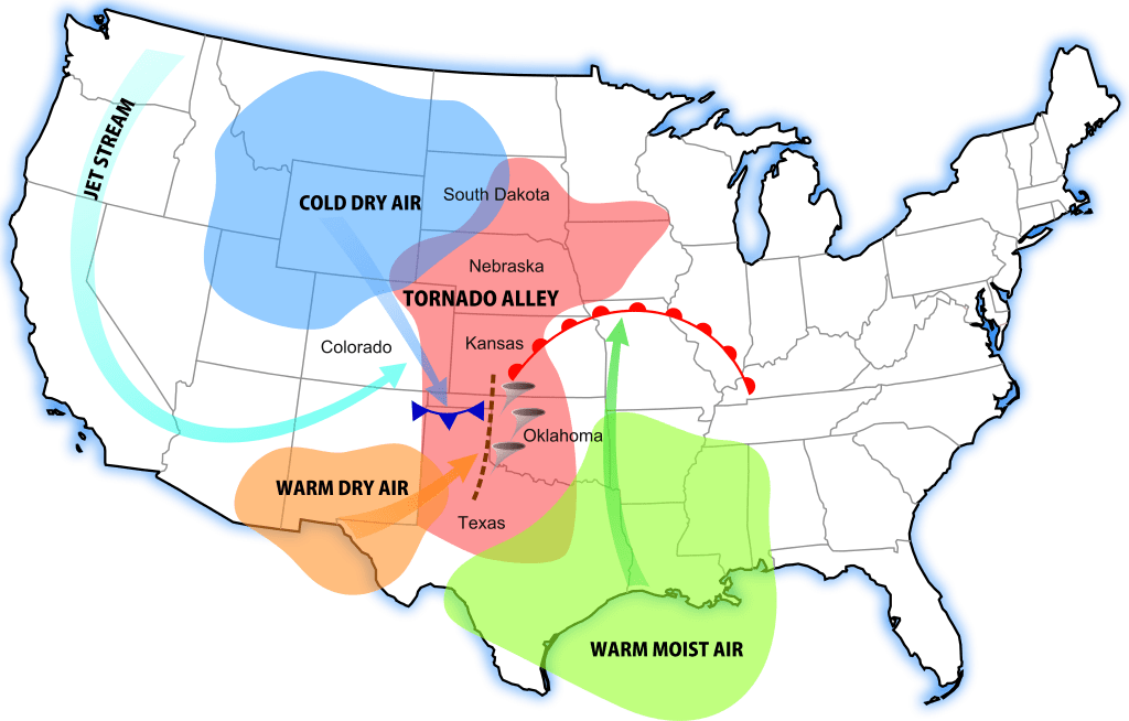
Where is Tornado Alley?-
Tornado Alley is constantly changing as forecasting and tornado research improves. The Tornado Alley is a zone of area that signifies the highest risk and most frequent number of tornadoes. Anyone in this area should be aware of storms especially since the conditions are usually more favorable for tornadoes in this region rather than in others. Of course, tornadoes still occur outside Tornado Alley but less often as records show. It is rare to see tornadoes on the coasts of America and it is most rare to see a tornado in California or Alaska.
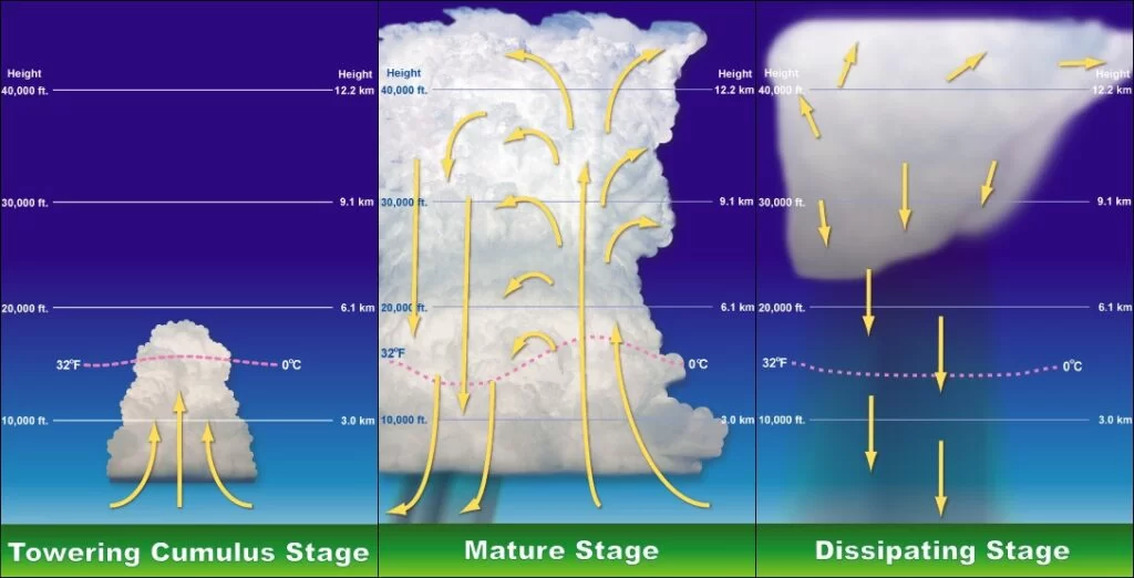
Severe thunderstorms all start with key ingredients: moisture, warmth, and lift. For a thunderstorm to develop, it first needs to have rising warm moist air. Rising warm air moves upward in the atmosphere creating puffy cumulus clouds on its way. This will continue as long as there is lift. Lift is provided by either convective heating (the suns heating of the atmosphere) and/or by difference in air density. This is known as the updraft of the thunderstorm. At some point, the cloud will reach the CAPE. This is a layer of cold air in the atmosphere, at about 30,000 feet, which prevents cloud growth beyond that point in most cases. Many weather models can tell you the strength of the CAPE in the atmosphere on a given day. When storms become severe, they generally have to punch through the CAPE. They do this due to their strong updrafts and other various conditions. Once the CAPE is broken, the thunderstorm can continue growing. At this point, the storms warm air will condense into water droplets and begin to cool due to the cold air above. This causes sinking cold air. This sinking cold air begins to form what’s known as a downdraft. This downdraft will bring down heavy rain and most likely hail. Now we have a working severe thunderstorm.
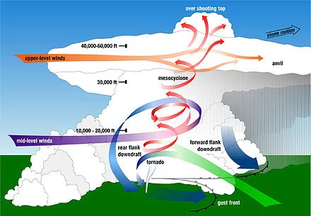
At different stages of a thunderstorm, they could turn to mesocyclonic storms. This means that the storm’s core rotates due to the wind speed differences at the different altitudes of the atmosphere (known as wind shear). This is one of the main steps in how a tornado must come to form. Let’s see how a tornado must form.
Tornado Formation
The basics of a tornado’s formation begins with the typical elements needed for storm development. Once the storm has formed, the element that really grows the storm ‘upward” is the warm, convective, moist, spring/summer air. Remember, whenever you see a cloud grow UPWARDS with towering columns, or even an “anvil-shaped” top, those are signs of a strong developing storm. Next, the storm could get the characteristics of a mesocyclone storm. A mesocyclone is formed when a strong updraft flows into a storm (all strong storms have one) and it meets with upper level winds. This is known as wind shear. Think of three air streams of wind flowing horizontally: One at 10,000 ft, the other at 20,000 ft, and the last at 30,000 ft. When you have a storm growing upwards (updraft winds with it), the updraft vertical winds will interfere with those horizontal winds more and more the higher the storm grows. This will form a rotating funnel within the storm. Back down on the surface, you may notice a wall cloud or a funnel if conditions are right. After, a tornado will potentially form. Just remember that a mesocyclone is one of the most important parts of a severe thunderstorm.
Thunderstorm Types
⛈️Supercell — A system producing severe thunderstorms and featuring rotating winds sustained by a prolonged updraft that may result in hail or tornadoes. A supercell also features a mesocyclone – a deep, persistently rotating updraft. For this reason, these storms are sometimes referred to as rotating thunderstorms. These last around 2-4 hours.
⛈️Single-Cell Thunderstorm — These storms may be powerful but usually only produce heavy rain and lightning. They typically don’t have enough energy to produce severe weather or have strong updrafts.
⛈️Squall Line — A strong line of thunderstorms that forms along or just ahead of an advancing cold front. These storms move very quickly usually causing widespread wind damage and potential for tornadoes. These storms are able to travel for hundreds of miles and can stretch over 1,000 miles length wise (from top to bottom)!
⛈️Multi-Cell Thunderstorm — A thunderstorm with many different sections and cells within it. They typically have many anvil heads and can get to be very strong storms. Multi-cells each have life cycles and stages within them: Growing, Mature, and Dissipating stages. Each cell can be at different stages at different times which means parts of the storm will be stronger or weaker than other parts.
Equipment for Chasing
Radar: A Storm Chaser’s Best Friend
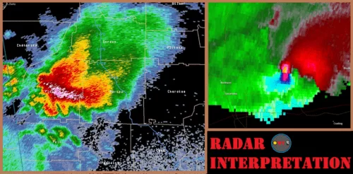
One of the best ways to track a thunderstorm is through a weather radar. This is an absolute essential when it comes to storm chasing. It can’t just be any weather radar; it must be a highly reflective Doppler radar. This will give you accurate and timely data for your location. Some of the best Radars for storm chasing are Radar Scope Teir II, Omega Radar, or some highly advanced radars like WSV3. To learn how to find the best weather radar or how to use a weather radar, check out some of WC’s blogs!
All technology has limitations. With weather radars, there are several things that are just too difficult for radars to track, predict, or forecast. This also means that a non-professional radar is not as accurate and correct as a professional doppler radar.
- Some weather radar apps or websites don’t have a very sensitive scan for tracking storms. What this means is that some radars (like satellite weather radar) do not pick up the precipitation/cloud structure/falling hail etc as well as a very high powered doppler radar does.
- Not all radars are extremely accurate, as I stated above. Sometimes the storm itself may be slightly off by a quarter or half mile because of the scan angle. Why aren’t all radars very accurate like some doppler radars? It’s really expensive to make those radars, and also the farther from the radar, the more inaccurate the data gets, so sometimes satellite radars for a larger area (for example when tracking hurricanes) are better. But whenever tracking severe storms over a small defined area, or for storm chasing, a doppler is a must have.
Dangers of Chasing
There are multiple dangers in storm chasing you must be aware of! First, some terminology must be understood. Then we can move into some of the biggest dangers of storm chasing and finally ending with some driving safety tips!
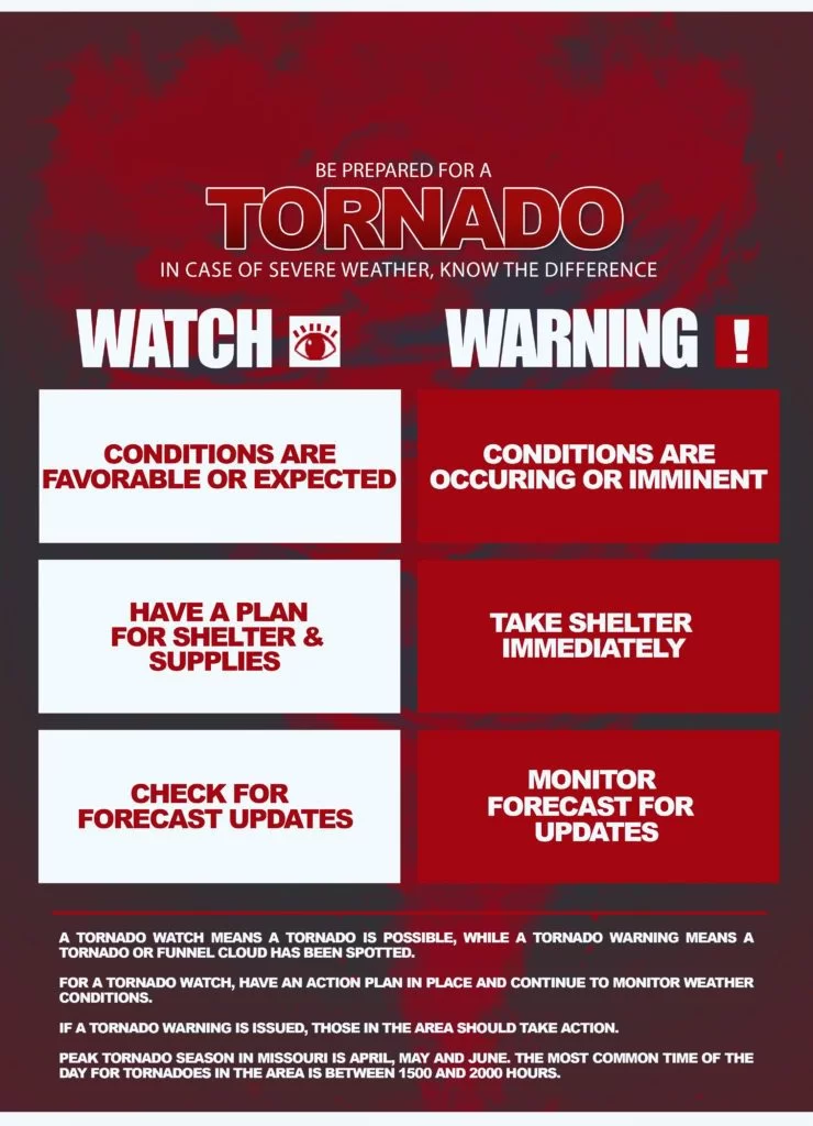
A TORNADO:
⚠️WATCH — is when conditions are favorable for tornado development.
⚠️WARNING — is when a funnel cloud has been spotted.
Take BOTH weather warnings seriously! With a watch just prepare and stay weather aware, but a WARNING requires immediate reaction and no delay! These warnings may only provide a couple minutes of notice before a tornado hits your area!
Hazards
-
Tornadoes: Tornadoes are some of the most dangerous parts of a storm chase. While they are the focus on most chases, they are also the deadliest. Chasing tornadoes should only be done by professional chasers. There are multiple aspects that must be taken into consideration during a chase involving a tornado. Many precautions and chasing decisions must be made in order to ensure the safety of the chasers. Some things to note for chasing tornadoes are:
- When driving parallel with a tornado (moving the direction you are), never be ahead of the tornado — It could change course and cross your road blocking your emergency exit route. Instead, stay behind the tornado to watch for sudden changes in direction so you can flee if necessary.
- Stay at a safe distance! Remember, debris can travel a long way from the tornado!
- DO NOT chase a rain wrapped tornado or a night-time tornado! Visibility is little to none. These are extremely risky and not worth the risk!

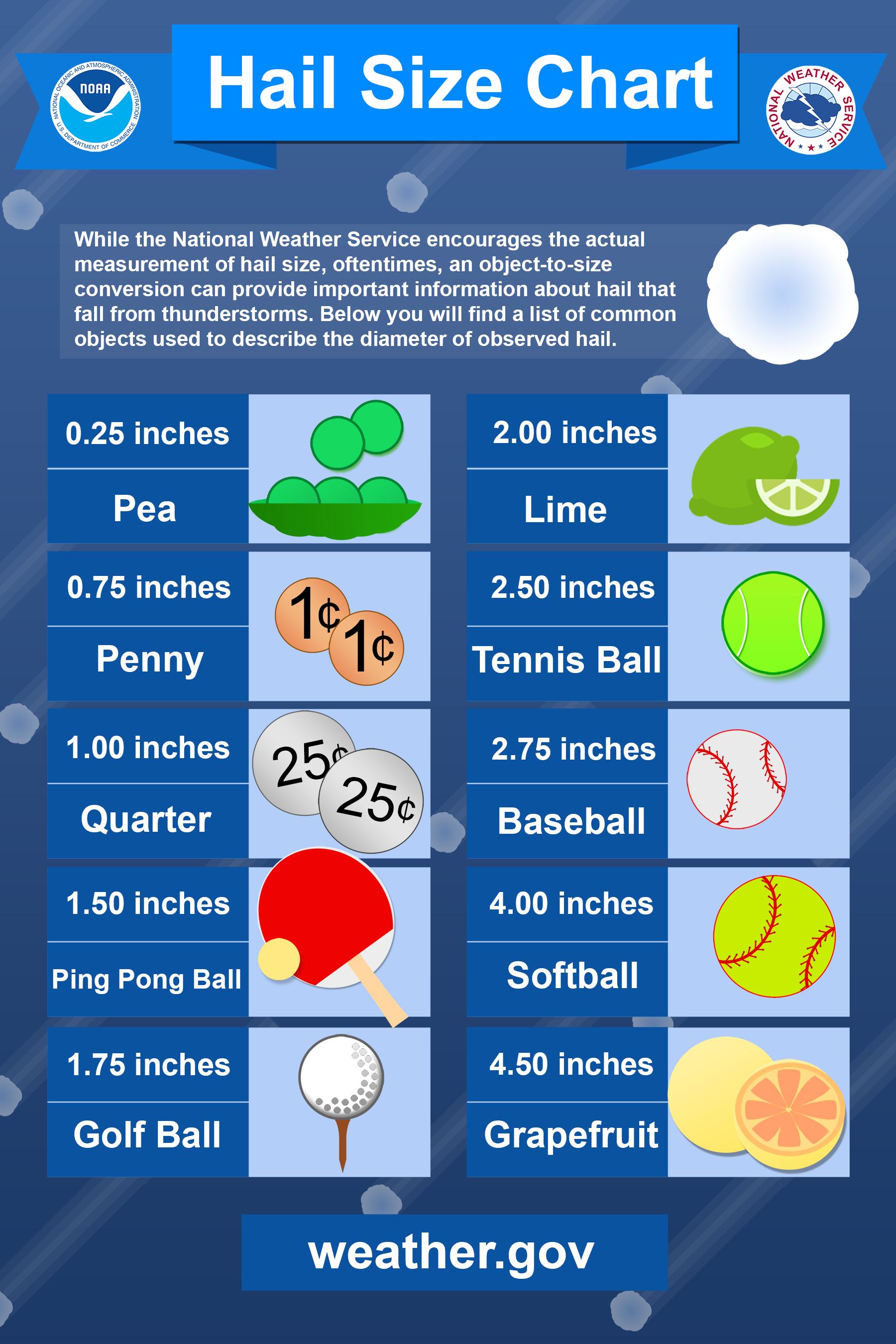
- Hail: There are many varieties of hail sizes that can pose a threat to your chase. One of the biggest dilemmas in storm chasing is if one should “core punch” in order to get to the desired location to see a tornado. Core punching means the chaser drives through the heart of the hail core of a storm, which means potentially sustaining large hail to your vehicle. This is usually always a bad idea. Large hail (2-3+ inches) can reach a speed anywhere between 49-90+ mph. If your vehicle is in motion, your speed will only add on to the velocity the hail hits your vehicle. For example, if you’re moving 60 mph and hail is falling at 60 mph, it would be close to essentially a 120 mph velocity impact on your windshield, which can easily go right through. Hail can shatter your windshield and damage your vehicle severely. This can cause injury to the persons inside the vehicle. Please DO NOT core punch!
- Storm Debris: Storm debris is a major threat to a chase. Storm debris can be flying through the air due to high winds which can pose a threat to your vehicle. Debris can also be on roadways due to a storm. This can make a road impassable or dangerous to drive on. Downed powerlines are one of the most dangerous since live wires can easily start fires or send currents through vehicles and anything that comes in contact with them. Also, don’t risk driving over tree limbs or wooden planks. These can easily cause you to lose control or allow nails to puncture your tires.
- Vehicle Wrecks: Driving fast with your eyes on the storm can sometimes result in reckless driving. Being unaware of traffic and other vehicles is a bad idea. Many accidents tend to happen during inclement weather, and chasers need to watch out for these kinds of things. Make sure to keep your eyes on the road and pay attention to other drivers and ALL of your surroundings.
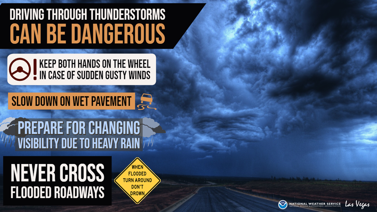
Driving Safe
It is important as mentioned above to drive safe during chasing. A chase cannot be successful without successful safe driving. Check out some safety tips for chasing down below.
Top 10 Mistakes In Chasing
- ❌Chasing Weather Warnings: Don’t chase a weather warning! Chasing weather warnings decreases the time you have to travel to the storms target zone that you are looking to get to. You should be able to be one step ahead and forecast your target zone before the warning is issued (this takes practice and skill).
- ❌Assume A Tornado Warning is a Tornado: A tornado warning means that a tornado has either been spotted or has been indicated by weather radar. Weather radar falsely indicates a tornado pretty often, since all technology has its flaws. Most of the time the weather radar is simply picking up on aloft rotation that has not formed into a tornado yet. This could lead you to a part of a storm which could turn out to be a waste of your time, especially if there are other cells with better potential.
- ❌Prioritizing Position Over Protection: Sometimes you could be tempted to get into the path of a tornado, a hail core, or on a dangerous road just to get a good view of the oncoming storm. Remember, safety should always take priority in your chasing! There isn’t a good chase without a good safety measure always being practiced! Storm chasing is very dangerous sometimes, your life and the others with you must remain protected.
- ❌Driving On A Near Empty Tank: A chase turns south as a multi-cluster severe thunderstorm producing tornadoes turns toward your position and the “low-fuel” indicator light turns on. This would be a storm chaser’s nightmare. Make sure to always have enough gas for your chase PLUS some for emergencies or extra unaccounted miles. Your vehicle is one of the most important parts of a chase. Without it, you are losing the chase and potentially in life threatening danger.
- ❌Not Coming Prepared For Chasing: A big chase requires a lot. It requires a plan, supplies, first aid, the right equipment, a good reliable vehicle, experience, etc. Novice storm chasers often forget some of the most important things you must have for chasing, and this can be extremely dangerous. Just imagine the regret you’ll have if your chase vehicle breaks down hours before the greatest chase opportunity of your life and it happened because you skipped the inspection you should’ve gotten for it!
- ❌Rating The Tornado You See By Visuals Only: Guessing a tornado’s strength should never just be based on what you see. This can be very misleading. Visuals alone cannot be sufficient for you chase. Ground reports from other chasers, debris, radar indication, and news reports must also be taken into account. Judging a tornado wrong can often lead you down dangerous roads or into traps.
- ❌Choosing Bad Roads: While storm chasing, you should avoid all dirt roads, especially if precipitation conditions are harsh. Even if you have a 4-Wheel-Drive vehicle, navigating muddy unpaved roads during deadly weather is an extremely risky position to be in. Usually only the most experienced and desperate chasers are willing to take this risk. High speed chasing on muddy roads is one of the ways chasers can land themselves in a ditch with their vehicle disabled.
- ❌Dangerous Driving While Chasing: The safety of others and the chaser comes before the chase of a severe storm. Do not break speeding and traffic laws just to reach a storm destination or intercept point in time! This will not only put you at more risk but also others at risk! The bad weather will already be adding a layer of risk to road conditions already. Be a safe driver.
- ❌Poor Communication With Your Chase Partners: If you are chasing as a team, communication is key! A multi-vehicle chase can be dangerous when it comes to a lack of communication. Chase members could become lost, trap themselves, or lose opportunities on a storm if communication fails. Stay connected!
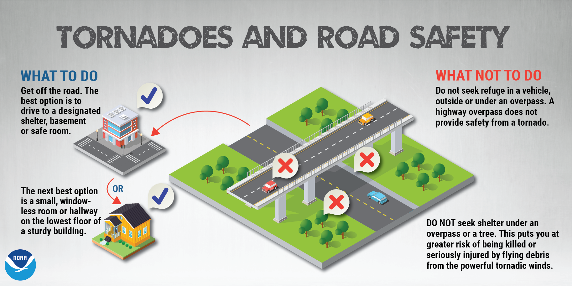
- ❌Seeking Shelter In The Wrong Places: Never find refuge under an overpass! It is not safe. It will only funnel debris and high winds underneath causing a deadly trap. In addition, do not take refugee from a tornado in your chase vehicle.* Your chase vehicle is not safe enough and is too light! Seeking shelter in a sturdy structure or even in a low lying ditch on the side of the road is safer!
*Assuming your chase vehicle is not a TIV (an armored tornado chasing vehicle)
Tips For Storm Chasers/Wanna-Be Chasers
Storm Chasing isn’t for everyone! – Not everyone is built for storm chasing. Not only is it a very risky business usually, but it requires a lot of patience, experience, and guts. Storm chasers must be committed, knowledgeable on what they are doing, and very weather aware!
Storm Chasing is a LOT of driving! – About 90% of chasing is driving to your chase-location. Only then do chasers actually “chase” the severe storm. Sometimes it pays off, sometimes it doesn’t. Usually chasing, depending on how committed you are, requires you to move state to state.
Storm chasing can range in many levels. Of course, there are the extreme chasers or chasers associated with news stations… But some of you may just want to chase in your hometown for the purpose of personal excitement of weather! This could just mean driving to locations to get the best photography of a storm but avoiding the actual dangers of the storm to begin with. These are what I call “Storm Gazers“. This is definitely the first step to becoming more of a storm chaser if you choose!
WC encourages you to pursue your passion of weather and chasing if you have one! Connect with WC today if you want help, or submit storm reports as you go out and find storms using the link below!
WC Storm reporter!
Become a WC Storm Spotter today in order to give storm reports about storms in your area! WC will use your data to help examine total threats faced by DFW to better forecasting! Become one today for free as a WC Member!
SKYWARN Program
You can become a local SKYWARN storm reporter for the National Weather Service in your local area! Just a free virtual or in person 2 hour class and you will become certified! After, you will be able to submit reports of local storms in your area. To do so, start HERE and find the next class to sign up for plus details!
(https://www.weather.gov/SKYWARN)
Definitions
Storm Chaser — Someone who pursues the art and science of chasing a thunderstorm.
Wall Cloud — A wall cloud is a large, localized, persistent, and often abrupt lowering of cloud that develops beneath the surrounding base of a cumulonimbus cloud and from which tornadoes sometimes form. It is typically beneath the rain-free base portion of a thunderstorm, and indicates the area of the strongest updraft within a storm.
Enhanced Fujita Scale — The Enhanced Fujita scale (or abbreviated as EF-Scale) rates the intensity of tornadoes in some countries, including the United States and Canada, based on the damage they cause.
Tornado Emergency — A tornado emergency is an enhanced version of a tornado warning, which is used by the National Weather Service (NWS) in the United States during imminent, significant tornado occurrences in highly populated areas. Although it is not a new warning type from the NWS, issued instead within a severe weather statement or in the initial tornado warning, a tornado emergency generally means that significant, widespread damage is expected to occur and a high likelihood of numerous fatalities is expected with a large, strong to violent tornado.
Tornado — A tornado is a violently rotating column of air that is in contact with both the surface of the Earth and a cumulonimbus cloud or, in rare cases, the base of a cumulus cloud. Tornadoes come in many shapes and sizes, and they are often visible in the form of a condensation funnel originating from the base of a cumulonimbus cloud, with a cloud of rotating debris and dust beneath it.
Rain-Wrapped Tornado — When extreme rainfall has reduced the visibility of a tornado significantly or has completely hidden the tornado.
Supercell — A system producing severe thunderstorms and featuring rotating winds sustained by a prolonged updraft that may result in hail or tornadoes. Characterized by the presence of a mesocyclone: a deep, persistently rotating updraft. For this reason, these storms are sometimes referred to as rotating thunderstorms. Lasts around 2-4 hours
All terms from Wikipedia
Resources
“Tornado Chasers” – Reed Timmer
A hit TV Show starring Reed Timmer, professional storm chaser! See the whole season 2 below now for FREE! It’s a thrilling show, action packed and well worth the watch!
Also read the hit storm chasing book called “Into The Storm” by Reed Timmer as well! This book seems to fully grasp the art of storm chasing and reveal some unbelievable tornado stories in dramatic fashion. This book is a must read for storm lovers, current storm chasers, or aspiring future storm chasers! Read the book now and read WC’s review on the book here!
Tornado Safety
In Texas, we all know what tornadoes are capable of — just look at the news! Here, you can learn what tornadoes are, what destruction they can cause, how to prepare for a tornado, how to properly execute tornado safety, what warnings and watches are, what to do during a tornado, where to be during a tornado, and what to do after a tornado! All of your questions answered here!
WC Tornado Center
WC has a page dedicated specifically for tracking tornadoes around your area! It consists of detailed weather models and information for your benefit! Go HERE to get started on tracking tornadoes!
- 7 Best Weather Websites
- Severe Weather 101
- WC Tornado Safety
- Storm Track
- Live Storm Chaser Map
- How to Interpret Weather Radar
- Watch WC Storm Chases!
- WC Tornado Center
Learn More Weather 101!
Types of Weather Section was made to inform viewers about all forms of severe weather that may be experienced or discussed about in WC posts! Here you can become weather aware and feel more prepared for severe weather! Each section includes details, graphics, videos, and resources to help the reader fully grasp the information given to them. Read more today!
[jp_post_view]