In this Texas Weather Center blog, WC will explain a few main things about Doppler Radar and how to interpret it. WC also will include useful links at the end of this article as well.
Why do I Need to Know This?
Learning about information like this can help in multiple ways in your daily life. A few of them could be:
- Knowing a storms direction when looking at personal radar. Future radar is not always the most accurate since technology is only so advanced at this point in time. Knowing about storm movement could help aid in preparation and safety measures for many.
- Knowing this information could save other people’s lives. With this information you can have your own interpretation of the weather, not just relying on professional meteorologists, which, don’t take me wrong, is very important to do. This can help you warn your friends and family about a storm that may be threatening their location.
Weather Radar Interpretation
How does Doppler Radar Work?
Doppler radar uses a technology similar to echo location. Like most radars work, weather radar has an antenna that sends out radio waves. When these waves hit any type of precipitation in the atmosphere, the waves scatter and some return back to the radar. The bigger the precipitation, the more energy there is that is sent back to the radar.
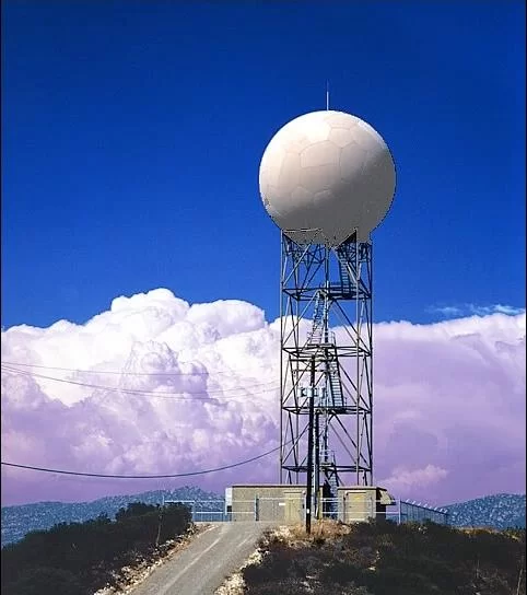
Why do these doppler weather radars always have domes over them? It’s what protects them from hail, wind, debris, etc. The actual instrument in there is just a radar dish on a rotating base that continually rotates 360 degrees every few seconds to scan the atmosphere. The radar does a sampling of scans from different scan angles (5 degrees, 10 degrees, etc). This provides a variety of data samples to insure accuracy.
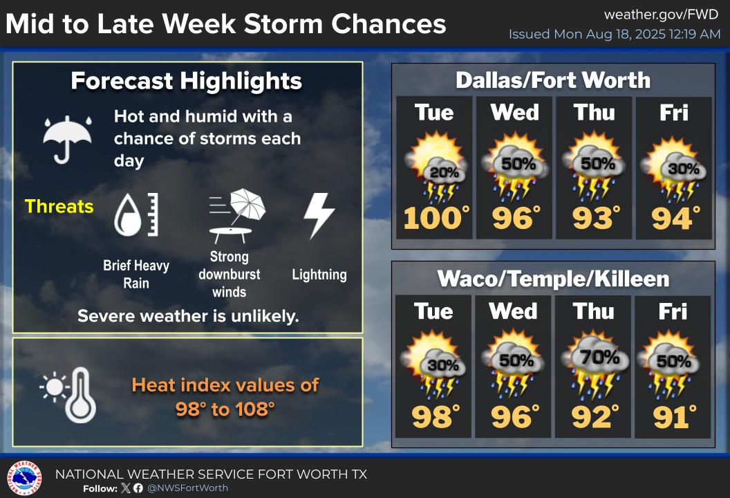
Basics on Reflectivity Colors
Most of you probably know the basics about the colors of your favorite weather radar app. For example, green is light precipitation and red is heavy precipitation etc. But what really are the colors?
PINK– This indicates hail in the storm. (65-70 dBZ)
RED- This indicates very heavy rain. (50-65 dBZ)
YELLOW- This indicates moderately heavy rain (40-50 dBZ)
GREEN- This indicates light to normal rain (20-40 dBZ)
*dBZ – This value is know as decibel. The higher the decibels the heavier the precipitation.
| dBZ | Rain Rate (in/hr) |
|---|---|
| 65 | 16+ |
| 60 | 8.00 |
| 55 | 4.00 |
| 50 | 1.90 |
| 45 | 0.92 |
| 40 | 0.45 |
| 35 | 0.22 |
| 30 | 0.10 |
| 25 | 0.05 |
| 20 | 0.01 |
| < 15 | No rain |
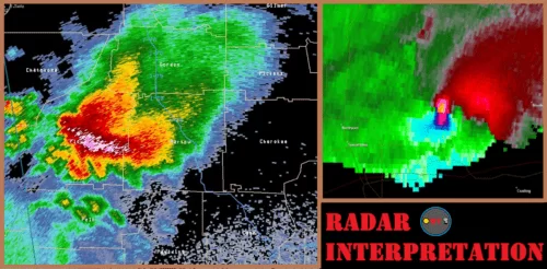
What is Velocity?
Velocity in reference to weather radar is a feature built into doppler radars to detect motion of precipitation. One thing Velocity is used most for is TRACKING TORNADOES.
The red color in velocity is depicting precipitation moving AWAY from the radar.
The green color in velocity is depicting precipitation moving TOWARDS the radar.

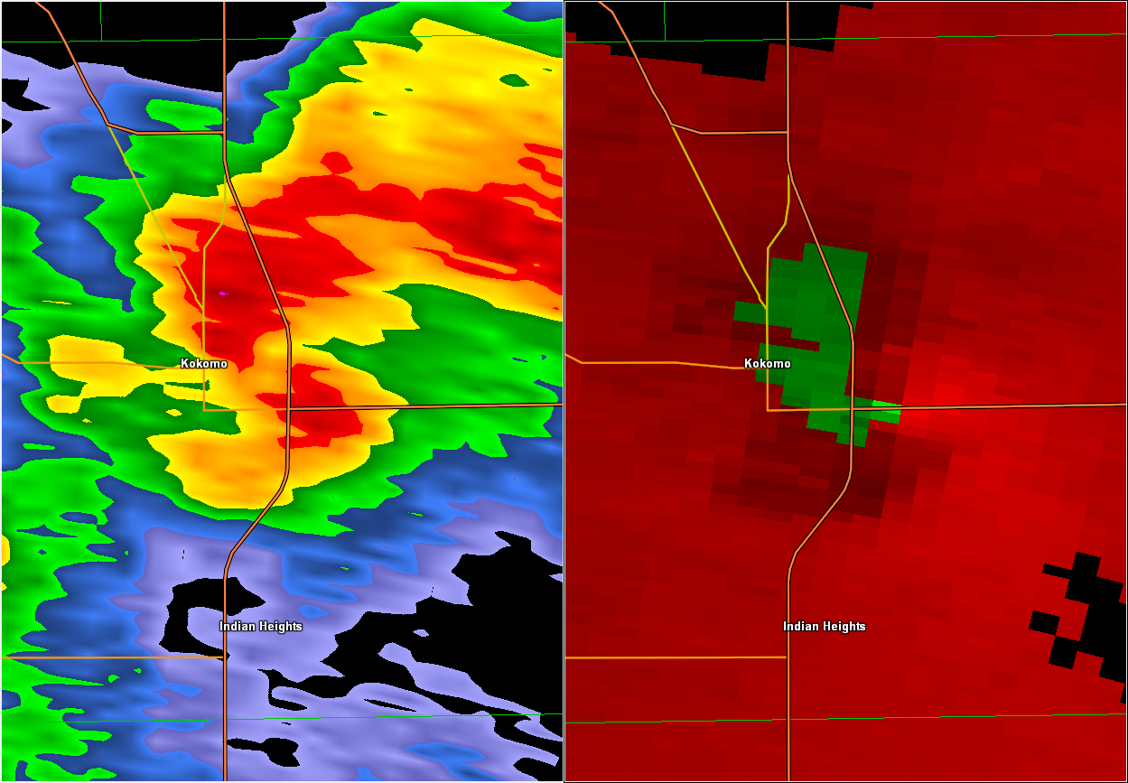
The way you can tell if there is rotation in a storm is when you have a red color surrounding a green color, like in the image above. This means the rain in the storm is being pulled one way while the other part is being pulled the other way, which signifies rotation.
Features to Watch for on Weather Radar
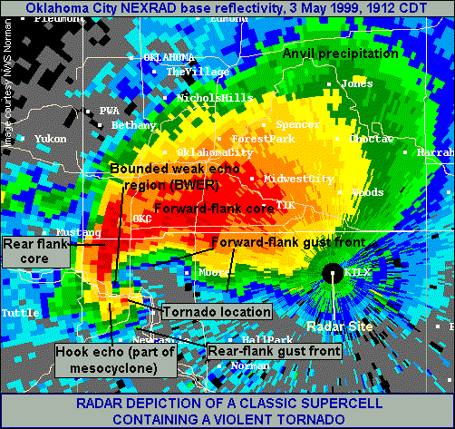
Hook Echo
A hook echo on radar is a distinct sign for rotation in a supercell thunderstorm. This is something that can be easily spotted at the lower part of a supercell or squall line storm. You’ll need a higher sensitivity weather radar to see this, since most radars from weather apps have a smooth texture default for the imagery so its not as fine detail. Most paid weather apps or programs have high quality radar imagery (including Radar Scope which is what WC uses).
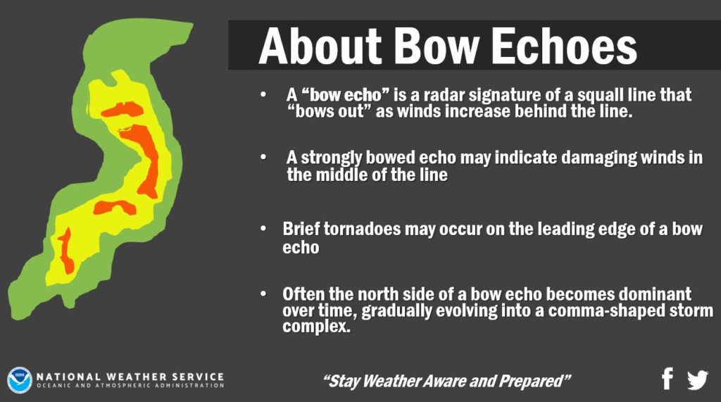
Bow Echo
A radar signature of a squall line that bows out as winds increase behind the line of the storm. Whenever you see a “bowing feature” in a storm, expect high winds for anyone that is hit by that part of the storm.
Know the Limitations of Weather Radar
All technology has limitations. With weather radar, there are several things that are just to difficult for radar to track, predict, or forecast. This also means that non-professional radar is not as accurate and correct as a professional doppler radar.
- Some weather radar apps or websites don’t have a very sensitive scan for tracking storms. What this means that some radars (like satellite weather radar) does not pick up the precipitation/cloud structure/falling hail etc as well as a very high powered doppler radar does.
- Not all radar is extremely accurate, as I stated above. Sometimes the storm itself may be slightly off by a quarter or half mile because of the scan angle. Why aren’t all radars very accurate like some doppler radars? Well it’s really expensive to make those radars, and also the farther from the radar, the more inaccurate the data gets, so sometimes satellite radar for a larger area (for example when tracking hurricanes) is better. But whenever tracking severe storms over a small defined area, or for storm chasing, a doppler is a must have.
Conclusion
Liked the blog? Make sure to send it to your friends and family to spread the word about WC and about the tips given in this blog about how to interpret weather radar. Remember, if you’re interested and don’t have a good weather app already, look at WC’s blog “7 Best Weather Apps” to find you favorite app today!
Useful Links
Become a TWC Member today for FREE!
Support Texas Weather Center
Join the TWC Membership through Patreon to show your support and keep TWC high quality and FREE!
Texas Weather Center Supporters
🥉Kathryn
🥇David Bass
🥉cslewis1234
🥉Robert Fasulo
🥈Carol