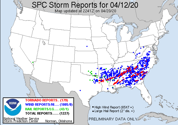
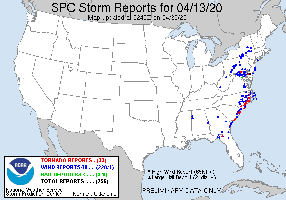
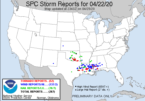
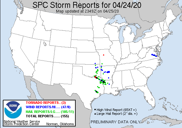
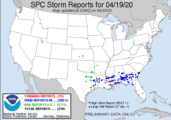
happy Sunday! Hope everyone is having a good day so far. What a week of severe weather though! Crazy Weather! Many storm systems have moved in and out leaving some towns in ruins and thousands of people impacted. Over 200 tornadoes have been confirmed in just the last 4 major storm systems, 2,000 high wind reports, and 500 hail reports! (4/12/20, 4/13/20, 4/19/20, 4/20/20, 4/23/20, 4/24/20)
As upper ridging builds over the western CONUS on Day 4/Tuesday, a shortwave trough embedded within northwesterly flow aloft should move southeastward across the Plains. A surface low is forecast to develop from the northern Plains to the upper MS Valley and Upper Midwest by Tuesday night, with a cold front surging southeastward across much of the central/southern Plains and mid/lower MS Valley. Moderate to strong instability will likely develop east of a surface dryline and south of the cold front by Tuesday afternoon across parts of the central/southern Plains into the ArkLaTex region. As large-scale ascent preceding the upper trough overspreads these areas, convective initiation along/ahead of both the dryline and cold front appears probable.
Severe Weather Analysis
The degree of instability forecast coupled with sufficiently strong shear suggests the potential for organized severe storms Tuesday afternoon/evening, and perhaps continuing into the overnight, from parts of southeastern KS into central/eastern OK, central/east TX, and the ArkLaTex. A 15% severe area has been introduced across this region for Day 4/Tuesday. All severe hazards appear possible, with upscale growth into a squall line along/ahead of the front likely by Tuesday night. At this time, the best severe threat may remain along and southwest of possible convection occurring Tuesday morning in a low-level warm advection regime across parts of AR. Some severe risk will likely extend farther north into MO and portions of the mid MS Valley vicinity, but instability may be somewhat weaker with northward extent over these areas.
Timing
A severe threat may continue on Day 5/Wednesday as the upper trough/low evolves and amplifies across the central/eastern CONUS. However, storms occurring along/ahead of the eastward-moving cold front may have a tendency to outrun the better low-level moisture return. Accordingly, instability is forecast to diminish with eastward extent. While shear should remain strong over parts of the lower MS Valley/Southeast into the TN/OH Valleys, there is too much uncertainty regarding sufficient instability to support organized severe storms to include a 15% probability area.
Confidence in the placement and timing of the upper trough/low decreases on Day 6/Thursday. If medium-range guidance that shows a slightly slower eastward progression of this feature is correct, then the cold front may not clear the East Coast until sometime later on Thursday. Some severe threat may persist across this area if this occurs, but predictability is low.
Upper ridging should dominate much of the central CONUS late next week into the following weekend, although there are considerable differences regarding the potential for low-amplitude shortwave troughs to move around the periphery of the upper ridge. Regardless, the severe potential for Day 7/Friday appears rather low with a cold front passage probably having shunted substantial low-level moisture offshore.
..Gleason.. 04/25/2020
Forecast data is produced manually by expert meteorologists at the NWS Storm Prediction Center. See their site for the most up-to-date official forecasts.
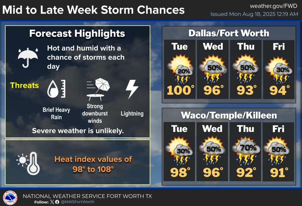
Another chance of severe weather is possible for DFW on Tuesday. It is too far out for WC to tell you for sure what kind or to what severity we are looking at in terms of weather or if it will be for DFW at all. In fact, SPC does not even have a Convective Outlook model yet for it. Stay tuned for the latest on it later this week.
Crazy Weather
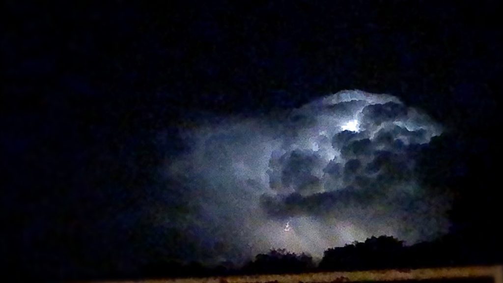
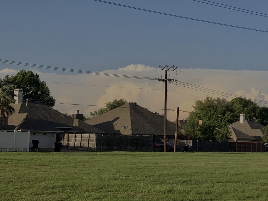
So, anyone got some good weather photos? WC has taken some AND received some from its fellow friends and photographers which we are so grateful to and now we want to share them! Here we go!
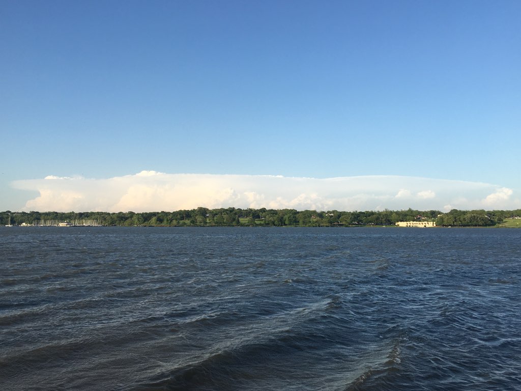
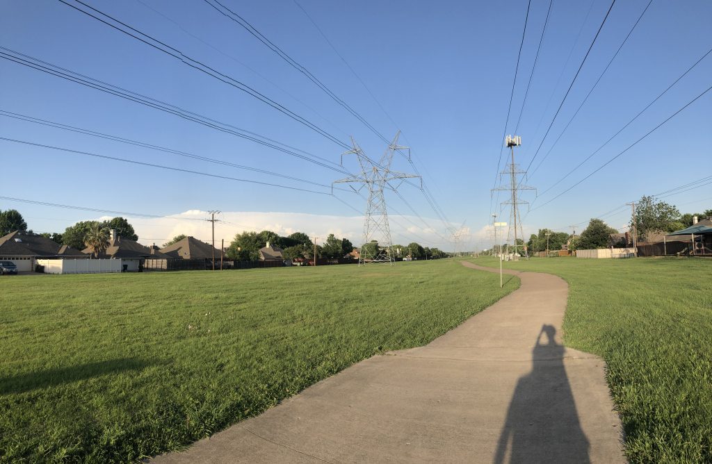
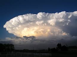
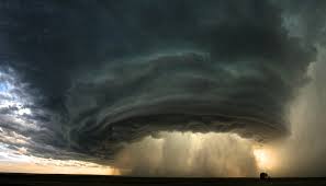
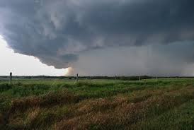
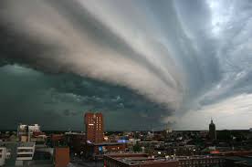
Photo by WhittPhoto taken by Jenny taken by WCTaken by WCcaptured by WCTaken by WC
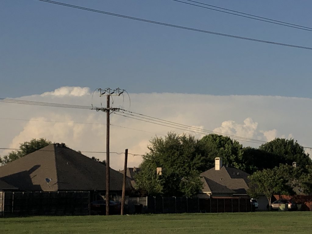
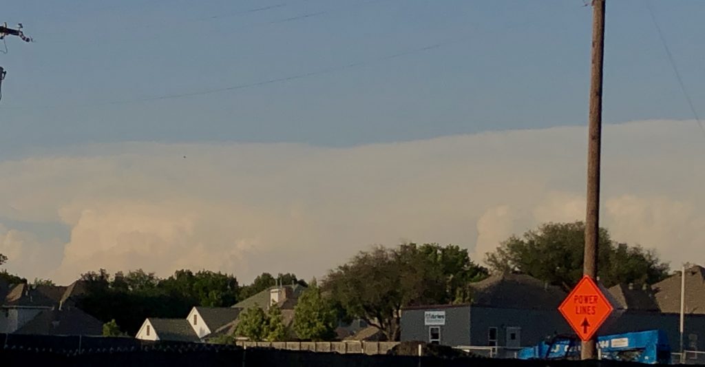
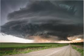
Check out some of these other cool anvil shaped clouds and then some shelf clouds! (An Anvil Cloud is a cumulonimbus cloud which has reached the level of stratospheric stability and has formed the characteristic flat, anvil-top shape. It shows that the thunderstorm has reached its mature stage).
Crazy Weather Time lapses
Comment below if you want to share some of your Weather Photos or Crazy Weather experiences!
WC T-shirts
Weather Center t-shirts will still come out! But due to the Coronavirus, it will be delayed until further notice. (potentially until June)
WC Game Day
Scheduled for 5/2/20. You won’t want to miss it! Winner gets 100 WC Skill points!
More
Weather Center has some big news that will be revealed on 5/2/20 (Saturday) This week! You won’t want to miss it! Stay tuned and Weather aware! Also a Member exclusive blog will be coming out soon as well as a new YouTube video! Check out WC’s YouTube Channel now!
happy Sunday! Hope everyone is having a good day so far. What a week of severe weather though! Crazy Weather! Many storm systems have moved in and out leaving some towns in ruins and thousands of people impacted. Over 200 tornadoes have been confirmed in just the last 4 major storm systems, 2,000 high wind reports, and 500 hail reports! (4/12/20, 4/13/20, 4/19/20, 4/20/20, 4/23/20, 4/24/20)
As upper ridging builds over the western CONUS on Day 4/Tuesday, a shortwave trough embedded within northwesterly flow aloft should move southeastward across the Plains. A surface low is forecast to develop from the northern Plains to the upper MS Valley and Upper Midwest by Tuesday night, with a cold front surging southeastward across much of the central/southern Plains and mid/lower MS Valley. Moderate to strong instability will likely develop east of a surface dryline and south of the cold front by Tuesday afternoon across parts of the central/southern Plains into the ArkLaTex region. As large-scale ascent preceding the upper trough overspreads these areas, convective initiation along/ahead of both the dryline and cold front appears probable.
Severe Weather Analysis
The degree of instability forecast coupled with sufficiently strong shear suggests the potential for organized severe storms Tuesday afternoon/evening, and perhaps continuing into the overnight, from parts of southeastern KS into central/eastern OK, central/east TX, and the ArkLaTex. A 15% severe area has been introduced across this region for Day 4/Tuesday. All severe hazards appear possible, with upscale growth into a squall line along/ahead of the front likely by Tuesday night. At this time, the best severe threat may remain along and southwest of possible convection occurring Tuesday morning in a low-level warm advection regime across parts of AR. Some severe risk will likely extend farther north into MO and portions of the mid MS Valley vicinity, but instability may be somewhat weaker with northward extent over these areas.
Timing
A severe threat may continue on Day 5/Wednesday as the upper trough/low evolves and amplifies across the central/eastern CONUS. However, storms occurring along/ahead of the eastward-moving cold front may have a tendency to outrun the better low-level moisture return. Accordingly, instability is forecast to diminish with eastward extent. While shear should remain strong over parts of the lower MS Valley/Southeast into the TN/OH Valleys, there is too much uncertainty regarding sufficient instability to support organized severe storms to include a 15% probability area.
Confidence in the placement and timing of the upper trough/low decreases on Day 6/Thursday. If medium-range guidance that shows a slightly slower eastward progression of this feature is correct, then the cold front may not clear the East Coast until sometime later on Thursday. Some severe threat may persist across this area if this occurs, but predictability is low.
Upper ridging should dominate much of the central CONUS late next week into the following weekend, although there are considerable differences regarding the potential for low-amplitude shortwave troughs to move around the periphery of the upper ridge. Regardless, the severe potential for Day 7/Friday appears rather low with a cold front passage probably having shunted substantial low-level moisture offshore.
..Gleason.. 04/25/2020
Forecast data is produced manually by expert meteorologists at the NWS Storm Prediction Center. See their site for the most up-to-date official forecasts.
Another chance of severe weather is possible for DFW on Tuesday. It is too far out for WC to tell you for sure what kind or to what severity we are looking at in terms of weather or if it will be for DFW at all. In fact, SPC does not even have a Convective Outlook model yet for it. Stay tuned for the latest on it later this week.
Crazy Weather
So, anyone got some good weather photos? WC has taken some AND received some from its fellow friends and photographers which we are so grateful to and now we want to share them! Here we go!
Photo by WhittPhoto taken by Jenny taken by WCTaken by WCcaptured by WCTaken by WC
Check out some of these other cool anvil shaped clouds and then some shelf clouds! (An Anvil Cloud is a cumulonimbus cloud which has reached the level of stratospheric stability and has formed the characteristic flat, anvil-top shape. It shows that the thunderstorm has reached its mature stage).
Crazy Weather Time lapses
Comment below if you want to share some of your Weather Photos or Crazy Weather experiences!
WC T-shirts
Weather Center t-shirts will still come out! But due to the Coronavirus, it will be delayed until further notice. (potentially until June)
WC Game Day
Scheduled for 5/2/20. You won’t want to miss it! Winner gets 100 WC Skill points!
More
Weather Center has some big news that will be revealed on 5/2/20 (Saturday) This week! You won’t want to miss it! Stay tuned and Weather aware! Also a Member exclusive blog will be coming out soon as well as a new YouTube video! Check out WC’s YouTube Channel now!
When you login first time using a Social Login button, we collect your account public profile information shared by Social Login provider, based on your privacy settings. We also get your email address to automatically create an account for you in our website. Once your account is created, you'll be logged-in to this account.
DisagreeAgree
Connect with
I allow to create an account
When you login first time using a Social Login button, we collect your account public profile information shared by Social Login provider, based on your privacy settings. We also get your email address to automatically create an account for you in our website. Once your account is created, you'll be logged-in to this account.