A tornado is a mobile, destructive vortex of violently rotating winds having the appearance of a funnel-shaped cloud. tornadoes form under a wall cloud under certain conditions. Moisture, wind shear, and temperature all come into consideration when tornadoes try to form in a supercell thunderstorms. A more simple definition of a tornado is a violently rotating column of air that extends down from a thunderstorm. Tornadoes, while most only last a few minutes, some can cause catastrophic damage very quickly in a localized area over a path of several miles. Go to the “Basic Safety Tips” section to see many important resources and also the “Good Resources” section to see the worst US tornadoes, some very interesting statistics, and outside source research.
-Where do Tornadoes Occur?-
Tornadoes happen all around the world. The most common area to find tornadoes is in the US with over 1,200 tornadoes on average a year. Keep in mind that tornado records and severe weather records only go back to the mid 1900’s, so any tornadoes before then could not get averaged up into this final number. So the US by far gets the most tornadoes per year. The second most common areas to find tornadoes in is Bangladesh and Argentina.
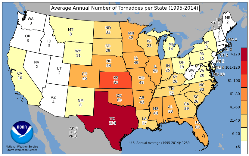
Over 1,200 Tornadoes are recorded in the US every year
-Where is Tornado Alley?-
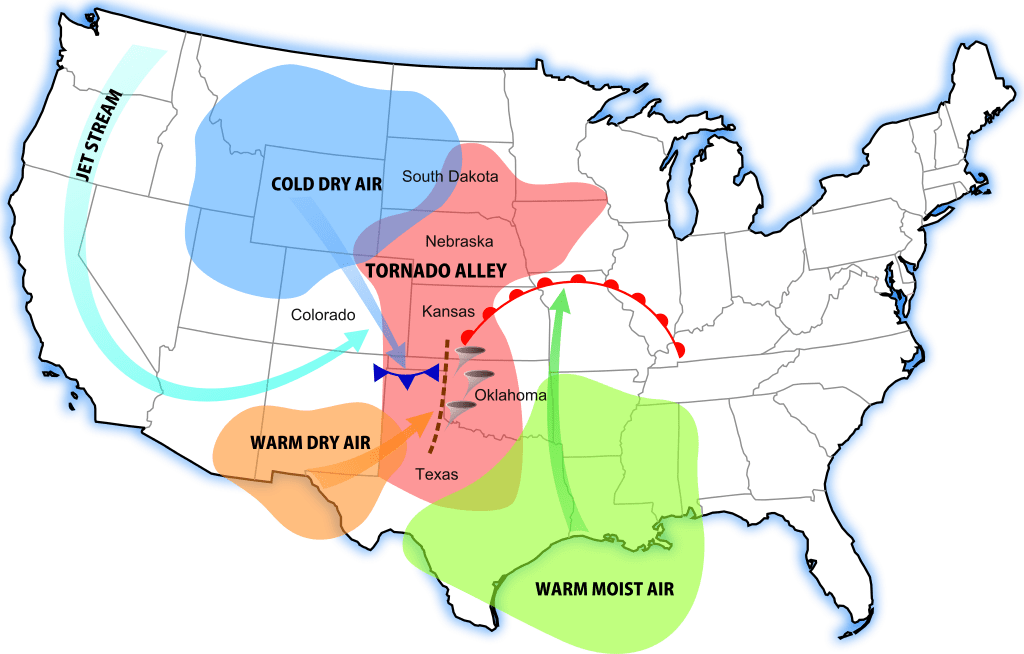
Tornado Alley is constantly changing as forecasting and tornado research improves. The Tornado Alley is a zone of area that signifies the highest risk and most frequent number of tornadoes. Anyone in this area should be aware of storms especially since the conditions are usually more favorable for tornadoes in this region rather than in others. Of course tornadoes still occur outside Tornado Alley but less often as records show. It is rare to see
tornadoes on the coasts of America and it is most rare to see a tornado in California or Alaska.
-What is the Enhanced Fujita Scale?-
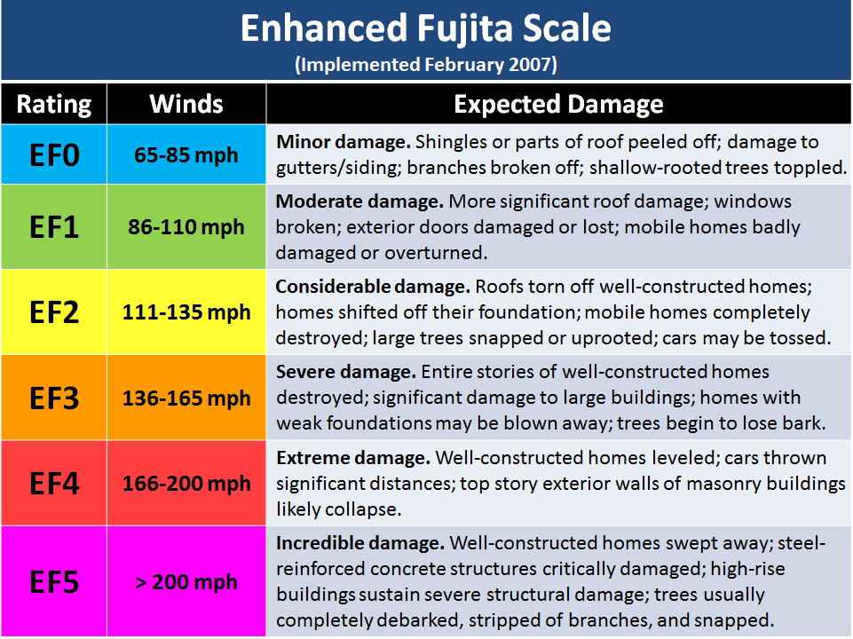
The Enhanced Fujita Scale is a rating scale for tornadoes ranging from EF0-EF5 and was made off of the original Fujita scale made in 1971. The EF scale was introduced not too long ago, in February of 2007. This scale tweaked the wind ratings a bit more from the last scale to align more accurately the with resulting damage done by wind from a tornado. This scale is usually abbreviated to “EF” and when you hear someone say “EF1 Tornado” you know they are talking about this scale and you can learn the scale here with this reference image to help you.
How does a Tornado Form?
Tornado History
Tornadoes have existed for as long earth has been around. Tornadoes appear in biblical writings as “whirlwinds.” Tornadoes have also been referenced by the Greek philosopher Aristotle in 4th century B.C. Unfortunately, back then, many believed severe storms and tornadoes were just their gods punishing them and that they controlled these. But, in reality and with all the modern technology, we have seen just how amazing yet complex the structure and design of a tornado really is. In the 1950’s the term tornado was just coming about. This was because before then meteorologists were forbidden to use the word “tornado” because they had no scientific explanation for such storms so they assumed it must be “dark” or “cursed” and must not be talked about. Now, in the 1950’s as tech slowly increased, they had the beginnings of instruments to gather data from storms and they began to learn more. They called tornadic storms “storm cyclones” and they called tornadoes “tornado cyclone.” Then in 1957 Theodore Fujita identified parts of a storm and proposed the first workable storm structure model that explained tornado and storm development. This gave way to the development of the “Fujita Scale” by him in 1971. Then finally in the 1970’s a supercell was defined as a separate storm type. This was confirmed just a year or two later as the Doppler Radar came out. Just look at the progression of technology we have now just in the past 50 years!
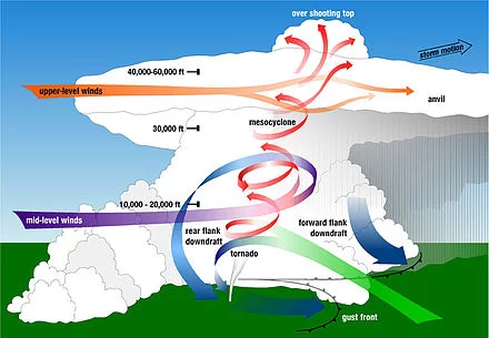
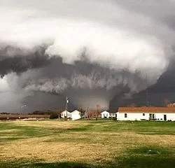
Tornado Formation
The basics of a tornado’s formation begins with the typical elements needed for storm development. Once the storm has formed, the element that really grows the storm ‘upward” is the warm, convective, moist, spring/summer air. Remember, whenever you see a cloud grow UPWARDS with towering columns, or even an “anvil-shaped” top, those are signs of a strong developing storm. Next, the storm could get the characteristics of a mesocyclone storm. A mesocyclone is formed when a strong updraft flows into a storm (all strong storms have one) and it meets with upper level winds. This is known as wind shear. Think of three air streams of wind flowing horizontally: One at 10,000 ft, the other at 20,000 ft, and the last at 30,000 ft. When you have a storm growing upwards (updraft winds with it), the updraft vertical winds will interfere with those horizontal winds more and more the higher the storm grows. This will form a rotating funnel within the storm. Back down on the surface, you may notice a wall cloud or a funnel if conditions are right. After, a tornado will potentially form. Just remember that a mesocyclone is one of the most important parts of a severe thunderstorm.
Tornadoes most often occur between 4-9 PM. When you notice these key characteristics in the sky, know a tornado may be near:
• Rotation: the clouds or a cloud deck is visibly rotating. It won’t be hard to tell. If you’re squinting to see if it really is, then it’s probably not a big deal. Real rotation is quite frightening and you should notice it immediately if you are looking. Seek shelter immediately.
• Greenish sky: this indicates that the storm may contain a lot of hail. This happens because ice crystals scatter the light around them and when you have blue light from water and a golden light from the sun, it can create a greenish tint in the clouds. This often signifies a tornadoes production may be close because large hail can be associated with supercell storms and what also comes with supercell storms? Tornadoes
-Types of Tornadoes-
There are many types of tornadoes such as cigar tornadoes, spiral tornadoes, cylinder tornadoes, etc. Here we will just go over the most common three:
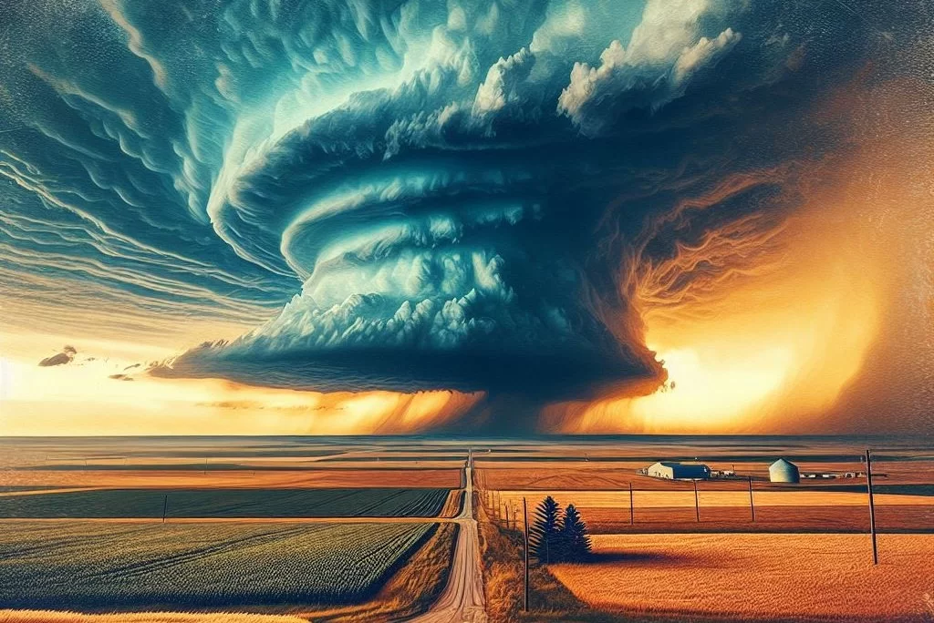
Wedge Tornado
A very large, wide tornado that commonly looks like this (pictured). V shape tornadoes are similar, but begin with a wide top but slim out as you go toward the bottom of the twister.
Rain-wrapped Tornado
A tornado which is obscured by a rain filled base (near the downdraft of the storm). This is when the tornado is virtually impossible to see to the naked eye because rain blocks out the structure. This can be very dangerous since this causes many to believe that “there is no tornado nearby” when in reality … there is.
Rope Tornado
A tornado that is very thin and usually moves much more violently through the air. This typically signifies a weaker tornado but not always. Look up pictures of rope tornadoes to see their eerie shapes!
Learn More Weather 101!
Types of Weather Section was made to inform viewers about all forms of severe weather that may be experienced or discussed about in WC posts! Here you can become weather aware and feel more prepared for severe weather! Each section includes details, graphics, videos, and resources to help the reader fully grasp the information given to them. Read more today!
[jp_post_view]