“Severe Weather Preparedness 101” serves as a user-friendly hub, providing essential information to the public about dealing with severe weather. With an accessible and straightforward approach, this page aims to equip individuals with the knowledge and tools necessary to navigate through severe weather events confidently. Severe Weather Preparedness 101 breaks down the complexities of severe weather into easy-to-understand segments. It offers insights into what severe weather encompasses, including thunderstorms, tornadoes, hurricanes, and floods. This foundational knowledge helps readers grasp the range of natural phenomena they may encounter.
To better understand your vulnerability to severe weather, the page offers practical methods of risk assessment. By considering factors such as your geographical location, local climate patterns, and past weather occurrences, you can gauge your level of susceptibility to different types of severe weather. This awareness empowers you to tailor your preparedness efforts to the specific risks you may face.
But “Severe Weather Preparedness 101” goes beyond awareness; it’s all about proactive readiness. It provides a step-by-step guide on how to prepare for dangerous weather events. This includes creating a family emergency plan, which outlines what to do, where to go, and how to communicate during a crisis. Additionally, the page emphasizes the importance of assembling an emergency kit with essential supplies like non-perishable food, water, first-aid materials, and tools.
The ultimate message of the page is one of community and shared responsibility. It encourages readers not only to prepare themselves but also to extend the knowledge and resources to their friends and family. By sharing this resource during the severe weather season, you contribute to a safety network that extends well beyond your immediate circle.
Severe Weather Preparedness 101 ultimately aims to arm individuals with awareness and readiness to face the challenges of dangerous weather events. Make sure to share this valuable tool with your loved ones to help create a web of preparedness, ensuring that everyone can navigate through severe weather with confidence and safety!
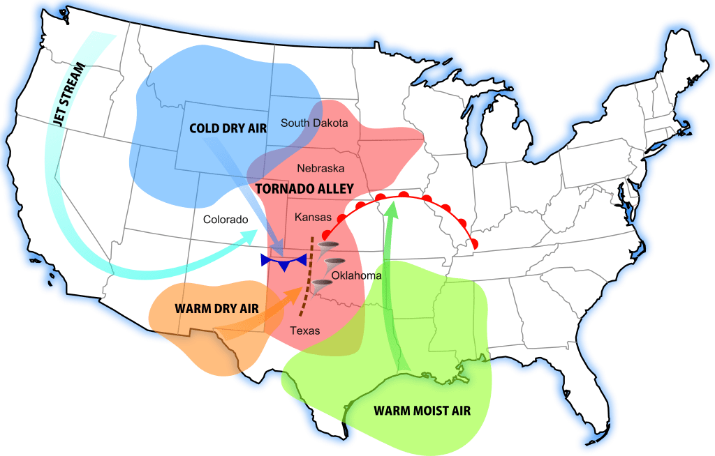
Tornado Alley is constantly changing as forecasting and tornado research improves. The Tornado Alley is a zone of area that signifies the highest risk and most frequent number of tornadoes. Anyone in this area should be aware of storms especially since the conditions are usually more favorable for tornadoes in this region rather than in others. Of course, tornadoes still occur outside Tornado Alley but less often as records show. It is rare to see tornadoes on the coasts of America and it is most rare to see a tornado in California or Alaska.
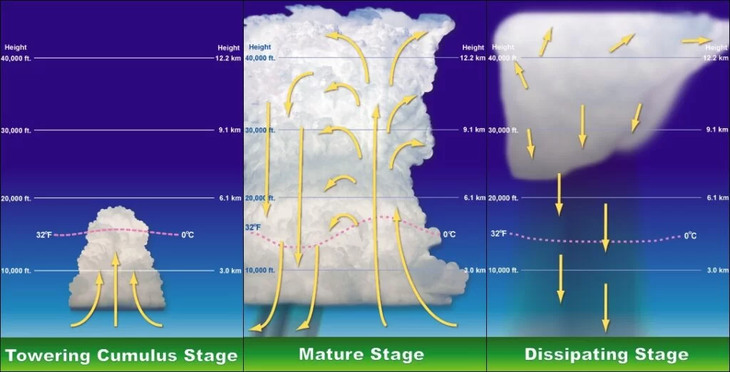
Severe thunderstorms all start with key ingredients: moisture, warmth, and lift. For a thunderstorm to develop, it first needs to have rising warm moist air. Rising warm air moves upward in the atmosphere creating puffy cumulus clouds on its way. This will continue as long as there is lift. Lift is provided by either convective heating (the suns heating of the atmosphere) and/or by difference in air density. This is known as the updraft of the thunderstorm. At some point, the cloud will reach the CAPE. This is a layer of cold air in the atmosphere, at about 30,000 feet, which prevents cloud growth beyond that point in most cases. Many weather models can tell you the strength of the CAPE in the atmosphere on a given day. When storms become severe, they generally have to punch through the CAPE. They do this due to their strong updrafts and other various conditions. Once the CAPE is broken, the thunderstorm can continue growing. At this point, the storms warm air will condense into water droplets and begin to cool due to the cold air above. This causes sinking cold air. This sinking cold air begins to form what’s known as a downdraft. This downdraft will bring down heavy rain and most likely hail. Now we have a working severe thunderstorm.
At different stages of a thunderstorm, they could turn to mesocyclonic storms. This means that the storm’s core rotates due to the wind speed differences at the different altitudes of the atmosphere (known as wind shear). This is one of the main steps in how a tornado must come to form. Let’s see how a tornado must form.
Tornado Formation
The basics of a tornado’s formation begins with the typical elements needed for storm development. Once the storm has formed, the element that really grows the storm ‘upward” is the warm, convective, moist, spring/summer air. Remember, whenever you see a cloud grow UPWARDS with towering columns, or even an “anvil-shaped” top, those are signs of a strong developing storm. Next, the storm could get the characteristics of a mesocyclone storm. A mesocyclone is formed when a strong updraft flows into a storm (all strong storms have one) and it meets with upper level winds. This is known as wind shear. Think of three air streams of wind flowing horizontally: One at 10,000 ft, the other at 20,000 ft, and the last at 30,000 ft. When you have a storm growing upwards (updraft winds with it), the updraft vertical winds will interfere with those horizontal winds more and more the higher the storm grows. This will form a rotating funnel within the storm. Back down on the surface, you may notice a wall cloud or a funnel if conditions are right. After, a tornado will potentially form. Just remember that a mesocyclone is one of the most important parts of a severe thunderstorm.
Thunderstorm Types
Supercell: A Supercell, an awe-inspiring meteorological marvel, gives rise to severe thunderstorms renowned for their sustained rotating winds fueled by a persistent updraft. This dynamic and formidable atmospheric system may unleash a variety of severe weather elements, including hail or, in more menacing scenarios, tornadoes. A defining characteristic of supercells is the presence of a mesocyclone, an enduring and deeply rotating updraft that imparts a swirling quality to these storms. Due to this distinctive feature, they are often colloquially referred to as “rotating thunderstorms.” Supercells typically maintain their intensity for a duration spanning approximately 2 to 4 hours, during which they exhibit a remarkable interplay of atmospheric forces.
Single-Cell Thunderstorm: In stark contrast, Single-Cell Thunderstorms, while occasionally potent, tend to confine their meteorological theatrics to copious rainfall and electrifying displays of lightning. These solitary storm cells typically lack the necessary energy and dynamics to foster the development of severe weather conditions or produce robust updrafts.
Squall Line: A Squall Line, a meteorological juggernaut of considerable magnitude, takes form as a formidable row of thunderstorms materializes along or just ahead of an advancing cold front. These formidable assemblages of storms are renowned for their rapid forward movement, often resulting in widespread wind damage and the potential for tornadoes. Remarkably, squall lines possess the capacity to traverse vast expanses, spanning hundreds of miles horizontally and stretching an impressive 1,000 miles from zenith to nadir.
Multi-Cell Thunderstorm: Multi-Cell Thunderstorms, on the other hand, represent intricate and multifaceted meteorological spectacles, harboring a multitude of diverse sections and individual storm cells within their convective embrace. These meteorological tapestries typically exhibit an array of anvil heads and possess the potential to evolve into formidable tempests. Notably, the life cycles of individual cells within these intricate convective systems are marked by distinct stages, including the Growing, Mature, and Dissipating phases. As a result, different portions of the storm may find themselves at various stages of development at different times, creating a dynamic landscape where certain areas exhibit heightened intensity while others wane in strength.
Storm Risks
There are several risks that come with storms and bad weather. Below are just a few examples of storm risks and the dangers they present.
Tornadoes
Tornadoes are extremely dangerous and can be one of the most destructive forms of weather. Tornadoes are sometimes unpredictable and can strike a location with incredible speed and power. The current warning time for a tornado is about 13 minutes, but sometimes its so much less. It is important that you act IMMEDIATELY when you are under a tornado warning and get to your safe room. Tornadoes in most cases are too hard to see until it’s too late. Rain wrapped tornadoes or night tornadoes are this way especially.
Storm Debris
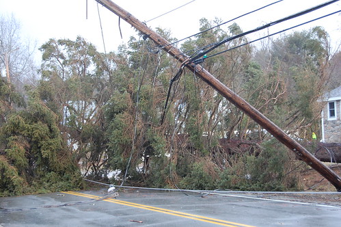
Storm debris is extremely dangerous. Debris is deadly. After a storm has passed over, debris may lay in its path. Downed powerlines pose an extreme threat to people around. Flying debris can damage structures and flying through windows as if they were missiles. Shattered glass from hail can be very dangerous too, whether from your vehicle or from your place of residence. If you spot debris on a roadway, do not try to pass it! You will most likely get stuck. Finally, if you are caught out in flying debris, curl up into a fetal position with your head down and cover your head with your hands clasped tightly over.
Flooding
Flooding is one of the most destructive forms of dangerous weather worldwide. Every country in the world almost has experienced deadly flooding. Flooding is simply caused by the displacement of water or excess rainfall that can flow through populated areas and cause damage. It is important to never be in situations where you are in a flood zone when a rainstorm strikes, like for example a creek bed. It is also important you stay alerted by flash flood warnings in your area especially if you live by rivers or lakes. Finally, traveling on roadways during heavy rainfall can be very dangerous due to water buildup in ditches that may cover the roadway or a hydroplaning risk with your vehicle.
Lightning
Lightning injures hundreds of people every year just in the US. Lightning from a storm can sometimes even strike you or a structure from over 50 miles away! It is important to never be outside especially out in the open when there is active cloud-to-ground lightning occurring. Another important note is to never operate any water equipment, swim, or take a shower during a thunderstorm. Lightning that strikes the ground can transfer into water in the pipes and pose a risk of electrocution.
Hail
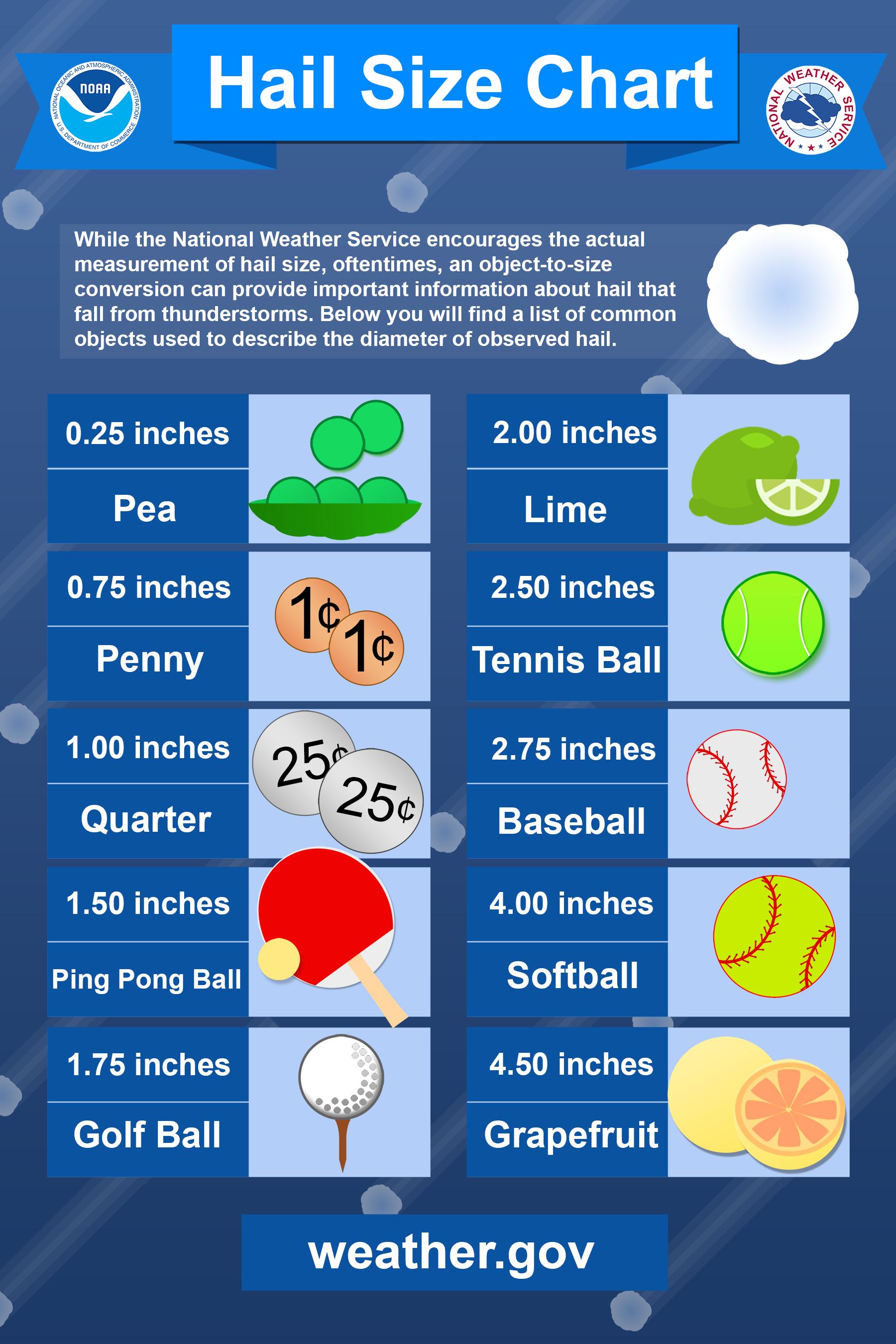
Hail can be extremely destructive as well. Billions of dollars of roof and vehicle damage occur every year due to hail damage. Hail can not only be a huge threat to your vehicle and/or your house, but also to you. Sometimes hail can grow larger than softballs. With a hailstorm producing hail of that size plus the rate of decent, it could easily cause casualties if anyone was caught outdoors. It is important to listen to the outdoor warning sirens about large hail and make sure you stay indoors away from windows during a hailstorm!
Damaging Winds
Damaging winds especially straight line winds, can be very dangerous. Not only can they cause extensive structural damage, but they can carry storm debris very easily. Flying debris is a huge concern with high winds. That’s why staying away from windows during high winds and inside a sturdy structure is crucial. Additionally, driving during high winds with high-profile vehicles can be extremely risky.
Understanding When Storms Become Severe
One of the biggest things that can benefit you if the knowledge of determining what weather you should be concerned about and what weather is not concerning. There are over 100,000 thunderstorms each year in the U.S. alone. Not all of them are severe or are concerning to your safety. So how can you know when a storm is really severe? There are several fairly simple methods you can use to approach this.
+
Severe Thunderstorms Every Yearin the US
$ Billion
In Damage Every Year in the US
Minutes
Average Warning Time for a Tornado
While a simple weather app can give you the forecast, not all of them will give you the details needed to help determine if severe weather will occur or not. Many find that some weather apps are very inconsistent, and they don’t give them straight answers.
There are a few alternatives that can give you information quickly.
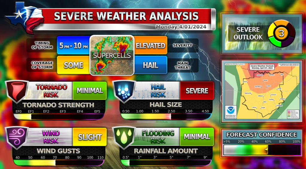
SPC outlooks are some of the best ways to determine risk levels for severe weather in your area! SPC makes it easy to understand your risks. There are 5 outlook levels:
Marginal – Scattered storms capable of severe hail, localized damaging winds, and a low chance of tornadoes. 1 Inch hail, 60 MPH winds, and/or a weak localized tornado typically could happen in this outlook level.
Slight – Increased confidence that some storms will be severe with higher a risk of severe hail, damaging winds, and/or tornadoes than the previous outlook level. 1-2 Inch hail, 70 MPH winds, and/or a couple weak tornadoes typically could happen in this outlook level
Enhanced – High confidence that many storms will be severe with higher a risk of severe hail, damaging winds, and/or tornadoes than the previous outlook level. 2-3 Inch hail, 70-80 MPH winds, and/or a couple tornadoes typically could happen in this outlook level
Moderate – High confidence that most storms will be severe with a much higher risk of severe hail, damaging winds, and/or tornadoes than the previous outlook level. 3-4 Inch hail, 80 MPH winds, and/or a few tornadoes (some strong) typically could happen in this outlook level
High – Very high confidence that a severe weather outbreak will occur in this area with a much higher risk of severe hail, damaging winds, and/or tornadoes than the previous outlook level. 4+ Inch hail, 80+ MPH winds, and/or several strong tornadoes (some very violent) typically could happen in this outlook level. This outlook is usually very rarely issued (1-2 times a year for the US)
SPC has several days that it displays outlooks for the public. Days 1-3 show convective outlooks levels (above), and Days 4-8 are % chances of severe weather. It is fairly unlikely that there are risk areas for Days 4-8 due to the fact long range severe weather forecasting can be inaccurate sometimes.
Day 1-2 displays the convective outlook levels and also the % chance of specific threats like hail, wind, and tornadoes.
See all of SPC’s outlooks displayed on WC’s page SPC Outlooks!
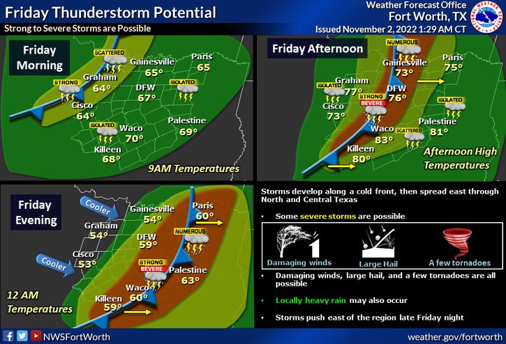
The National Weather Service of Fort Worth Texas issues weather graphics and info graphs daily for the area. Many of these graphics are for severe weather watches, alerts, and predictions for coming storms. These can be very helpful and are extremely easy to understand and interpret. WC has a slider of all the latest NWS forecasts on its homepage! Some of these graphics are so much more helpful than weather apps when it comes severe weather forecasting. You can get a ton of information for the next coming days for severe weather risks by just going to NWS FTW!
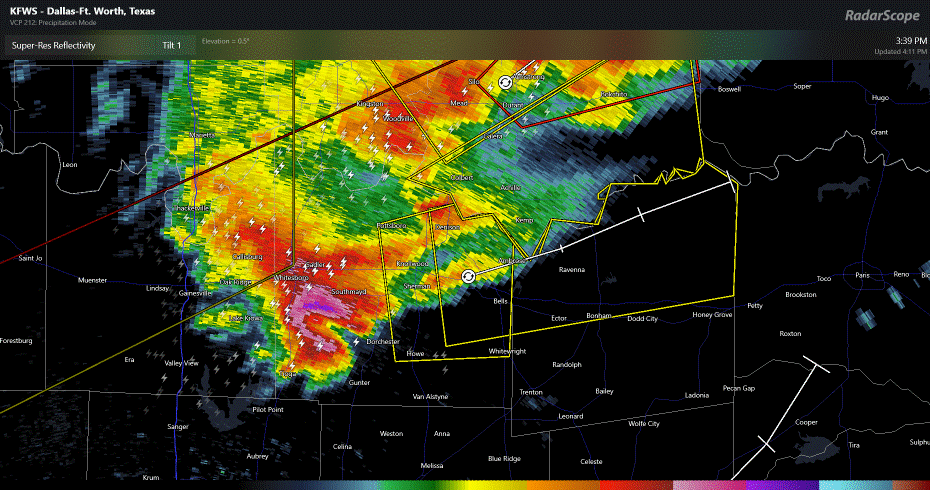
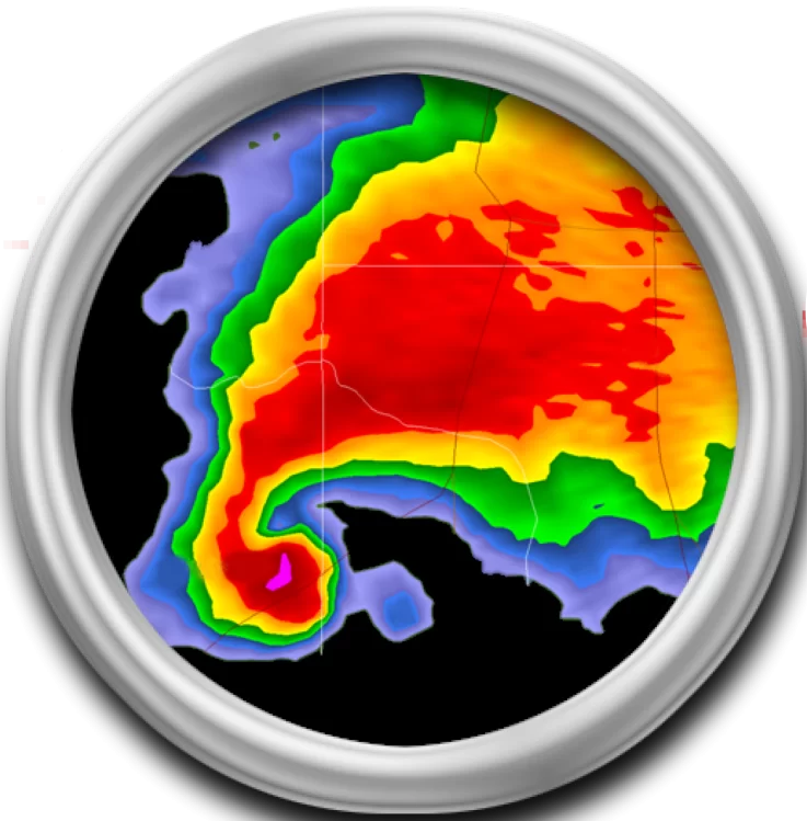
Radar Scope is one of the most affordable advanced weather radars for weather lovers and storm chasers! It includes many useful features for tracking storms and has very high detailed reflectivity layer which provides accurate storm location and storm analysis! WC is a proud user of Radar Scope and encourages you to get Radar Scope as well! Not only is this radar great for the general public, but storm chasers can use this radar too, especially new storm chasers! It doesn’t take long to learn how to operate this radar and you can always upgrade your plan later to access more features!
Radar Scope is only a one-time payment of $10 for an IOS device and $30 for Windows! Upgrading to Tier I or Tier II will unlock you more benefits and features in the app if you choose to upgrade. Click below to download the app for yourself!
There are a couple other professional radars WC would like to mention:
The first radar WC would like to mention is Omega Radar. It is a fairly newer radar and has been gaining popularity fast lately. It includes a lot of features similar to Radar Scope and it is trying to compete with Radar Scope in many ways. There are several amazing features like 3D radar that Omega Radar offers that others don’t! While the cheapest plan is $49.99/year, Omega Radar is still a good second option.
This last radar WC would like to mention is hands down the most complex advanced radar out there for the general public to use. It is called WSV3. This radar offers the most complex and advanced features any radar could offer for the public. It even takes a good computer to run this radar. This just shows the amazing power of this program. While spending $240/year to own this radar may not be worth it for most people except for storm chasers, this radar is definitely the most advanced out there. WC highly recommends this radar for professional storm chasers who are willing to up their game and invest a little bit of money.
For the advanced few out there, this page is for you! Learn some of the basic ins and outs of a weather sounding. Remember a weather sounding is a compilation of data collected from weather balloons that are launched at hundreds of locations all around the US. If you want to read the page, click on the button below!
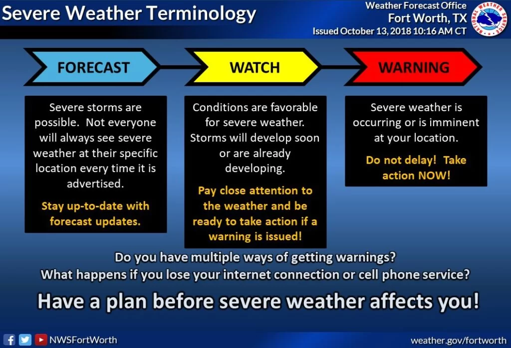
📑Outlook: An outlook means a form of severe weather is possible for that given area in the next 5-7 days. Generally seen in the form of hazardous weather outlooks or other forms. Also can be a convective outlook issued by SPC which indicates risk level areas for severe weather that day.
🚩Advisory: Typically used to describe a weather event that is likely to occur, for example a Wind Advisory. Advisories are commonly and typically only issued for non-severe weather events.
🛑Watch: A watch means that conditions are favorable for severe weather. Storm can develop in the next few hours and can become severe quickly. Each watch issued has different hazards listed for what to expect in the storms. Watches are typically issued a couple hours before the first storms begin to develop and turn severe.
⚠️Warning: A warning is issued when there is an ongoing imminent threat to that location of severe weather. Action must be taken IMMEDIATELY!
What are Outdoor Sirens?
Outdoor warning sirens are made to protect the general public from dangerous weather. Many believe they are only sounded for tornadoes. That’s not true. These sirens, while they are mostly sounded for tornadoes, can be sounded for very large hail and damaging winds. These sirens are sounded first to warn people who are outdoors or traveling. It is loudest for them, so immediate action is needed in order to get indoors and safe. People indoors should heed the warning and enter their safe room in their home immediately. If the siren is for large hail, do NOT be by any of the windows of your home. For both tornadoes and high winds, seek shelter in the safe room of your home immediately.
What Never To Do
⚠️Never Be Unprepared for Severe Weather!
When severe weather strikes, you will want to be prepared! Following the latest weather sources like WC discussed above will save you from un-wanted surprises in the future when it comes to severe weather. No one wants to be caught out in a tornado while driving down the highway, yet many are! Knowing what to expect will allow you to plan ahead so that you can stay home if possible, shift your day schedule around, or plan alternate travel routes to ensure you can stay safe during an active severe weather day!
⚠️Never Try to Spot a Tornado!
When outdoor warning sirens are blaring and a tornado warning is issued for your area, some people’s curiosity gets the best of them. Please DO NOT go outside to try to spot a tornado! Not only is this extremely dangerous, but you will likely not even be able to spot the tornado. Many tornadoes can be rain wrapped or hidden by tall trees or structures. Many can be sudden and approach out of no-where. Night tornadoes are essentially impossible to see. Just don’t do it! Get to your safe room immediately and follow your local weather news for information!
⚠️Never Ignore Warnings!
Warnings are made for your protection! Warnings usually indicate life threatening severe weather that is imminent for your location. It is important you act immediately since warning time isn’t always very long! While you may not want to always follow the warning, just think of it as a safety precaution that can save your life. Think what would happen to you if you never took the necessary safety precautions and you got caught off guard by extreme hail or a tornado? Warnings save lives, and so can you if you follow them and encourage your friends and family to as well.
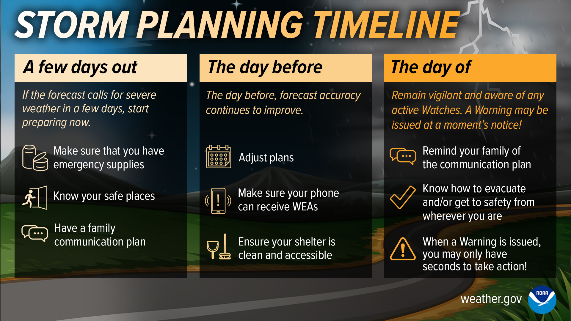
5 Ways to Prepare for Severe Weather
1. Have a Storm Plan
Be prepared for severe weather that’s in the coming week and plan your schedule accordingly to allow flexibility if dangerous weather did strike. Be sure you have emergency supplies.
When forecasted severe weather is only a day away from occurring, make sure you know your safe room and have planned your day schedule accordingly.
Continually check for weather updates online, on apps, or your local news station while severe weather is immanent and be sure to take action if any weather warnings were to be issued!
2. Understand Possible Weather Hazards
ACTION – Take shelter immediately in a sturdy structure away from windows in an interior room.
ACTION – Move indoors away from windows.
ACTION – Move indoors if you hear thunder.
ACTION – Move indoors away from windows into interior rooms.
ACTION – Avoid rising creeks and water-covered roads.
3. Have a Way to Receive Weather Warnings
Download a Weather App – Weather apps are very useful in so many ways in our daily lives. Not only do they give us the forecast, but most out there have weather alert notifications that come right to you phone! Check out the 7 Best weather Apps blog to find out the best weather app!
Enable Emergency Weather Alerts – On all iPhones after IOS 15.4, emergency weather alerts are delivered straight to your phone, bypassing silent mode or “do not disturb” so that you can receive the necessary warning for the life-threatening event possible in your area at that time.
4. Tune into your local Weather News Channel
Stay Updated with live weather coverage – Your local news station will always cover live severe weather in your area. They will give out valuable life-saving information and live warnings that are issued. You can stay updated on everything with your local news station when storms strike!
Invest in an emergency weather radio – Even if you have access to a TV for live weather coverage, it is a good idea to have an emergency weather radio since its portable, able to be with you in your safe room, and useful in cases where the power is out.
5. Understand Weather Models
Be knowledgeable on weather models – If you understand weather models like for example WC’s weather model, you can better understand if your area is at risk for severe weather and what to expect. There are many weather models out there including National Weather Service, Storm Prediction Center, Pivotal Weather, etc
Search for weather models that you understand best – WC recommends searching “NWS FTW” in your search engine. This page shows several relevant graphics that are extremely helpful in determining the severe weather risks in your area
After the Storm
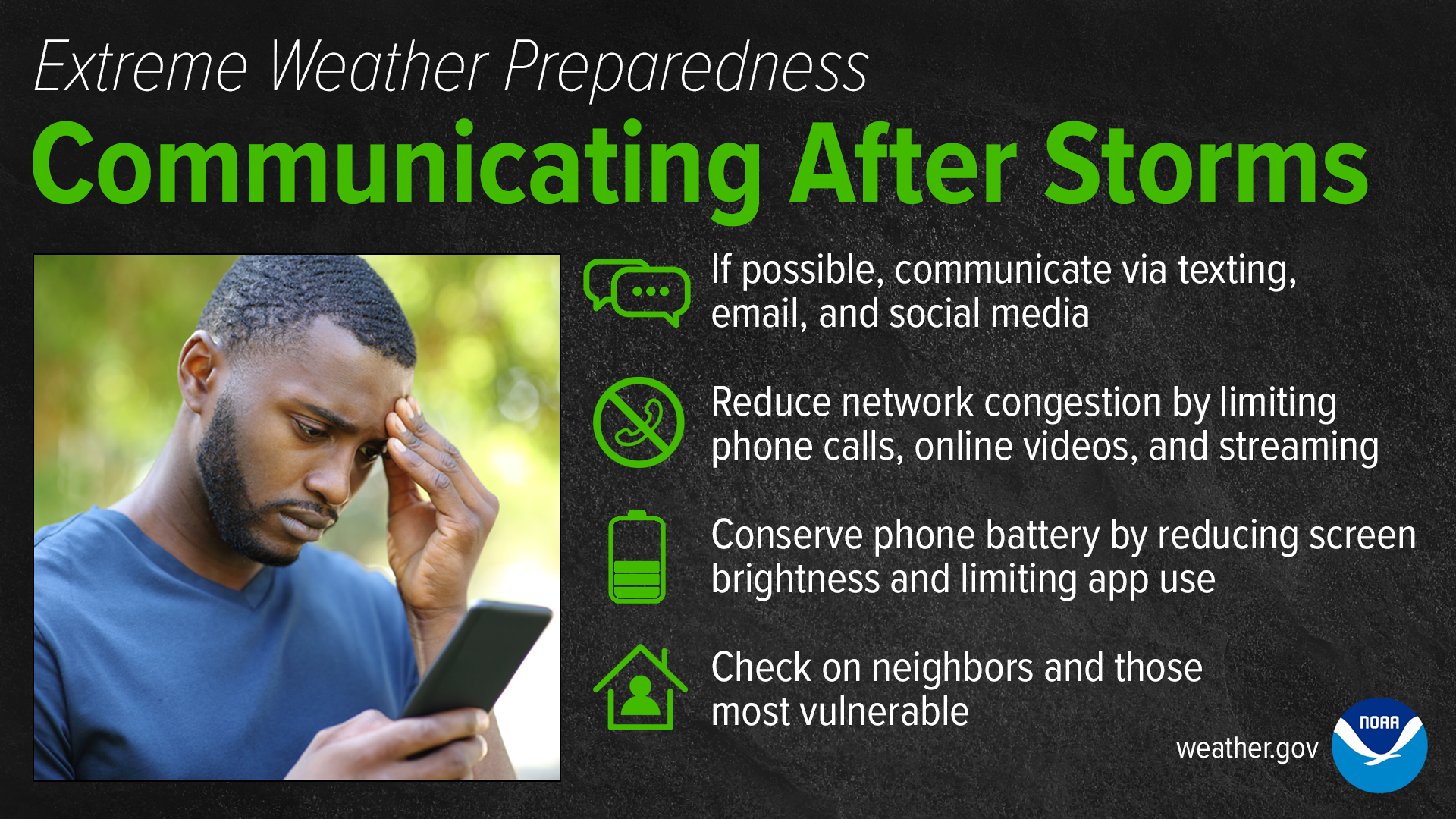
ACTION – Communicate via text only if at all possible. Network channels will be extremely slow in some cases and data transferring will be impacted greatly.
ACTION – Conserve battery life on all your devices. Power outages are common with bad/destructive storms
ACTION – Stay indoors and away from downed powerlines, dangerous debris, etc. Wait until the storm has passed completely before going outdoors.
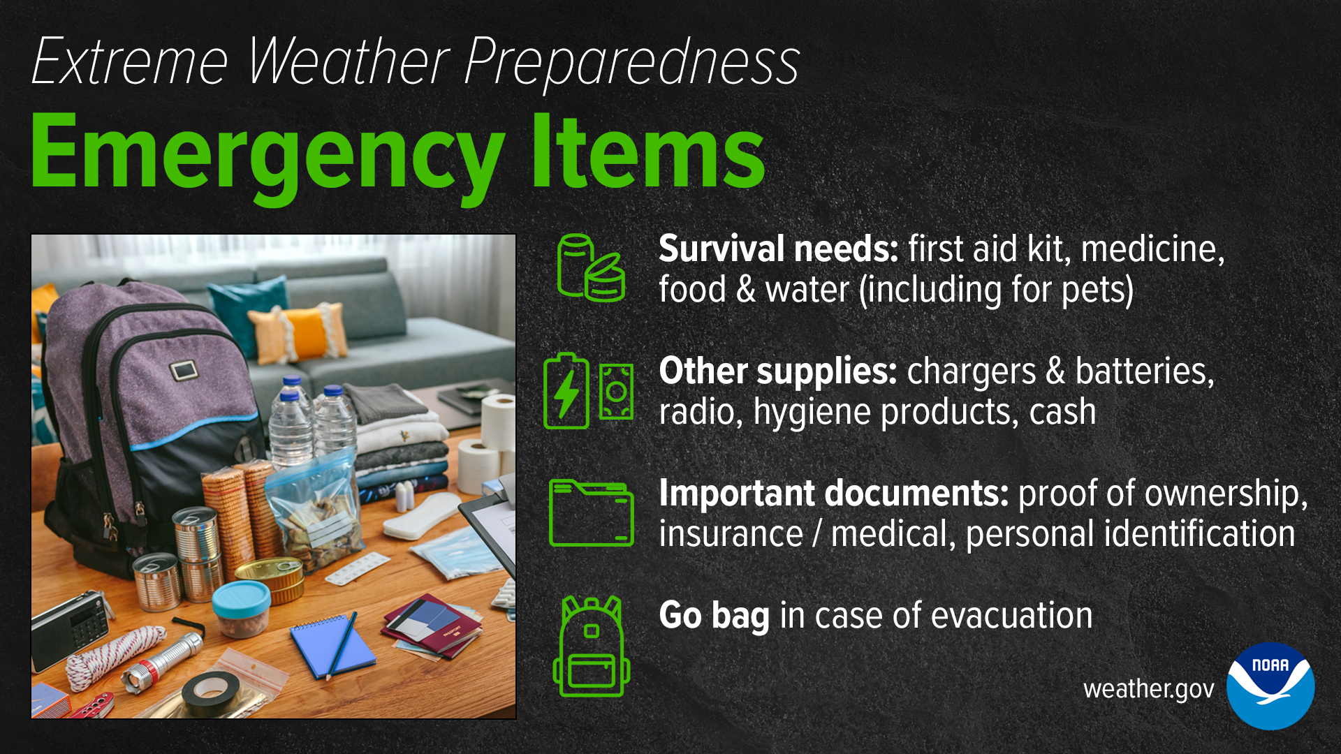
Survival Items: first aid kit, medicine, food & water.
Other Supplies: phone chargers, external batteries, weather radio, spare cash, backpack, shoes, bike helmets (for tornado warnings), multitool (optional), etc
Important Documents: Proof of residential ownership, insurance, personal indentation, other important information
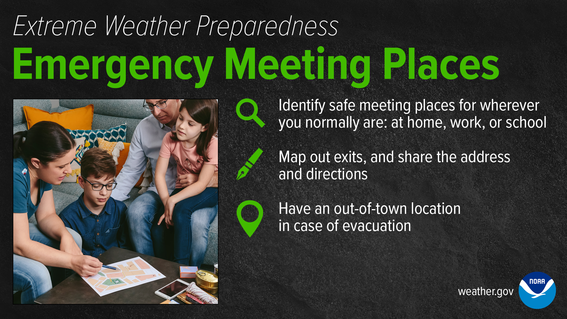
ACTION – Identify safe meeting places at home, work, school, etc. This will be the place where you go to meet up after the event of a natural disaster if members were separated from each other.
ACTION – Know your exits in the building you are in so that in the event of a natural disaster you know how to exit safely. Know your hallways, exits, stairwells, etc. Avoid use of elevators!
ACTION – Have a backup location to stay in case of evacuation or damage/destruction to permanent residence.
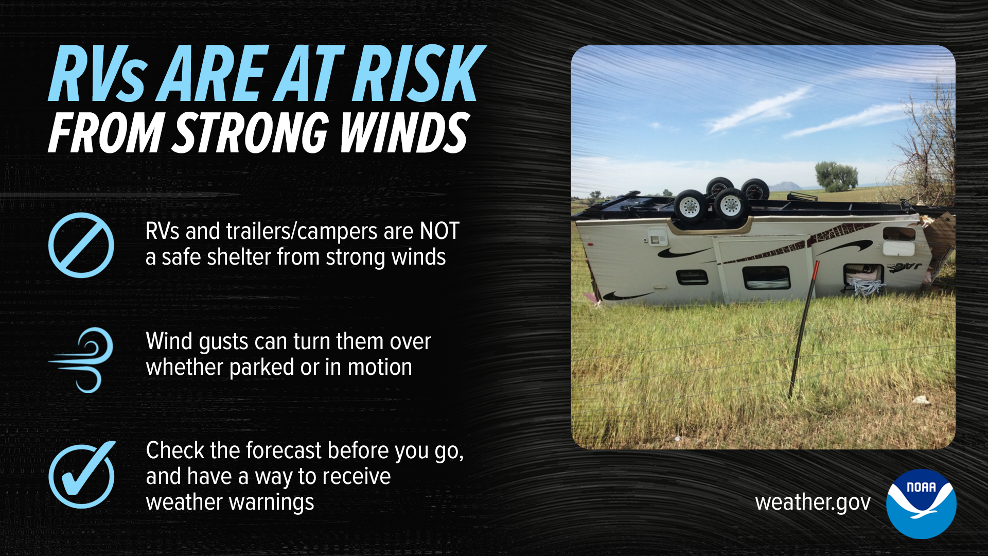
Strong Wind Safety Tips
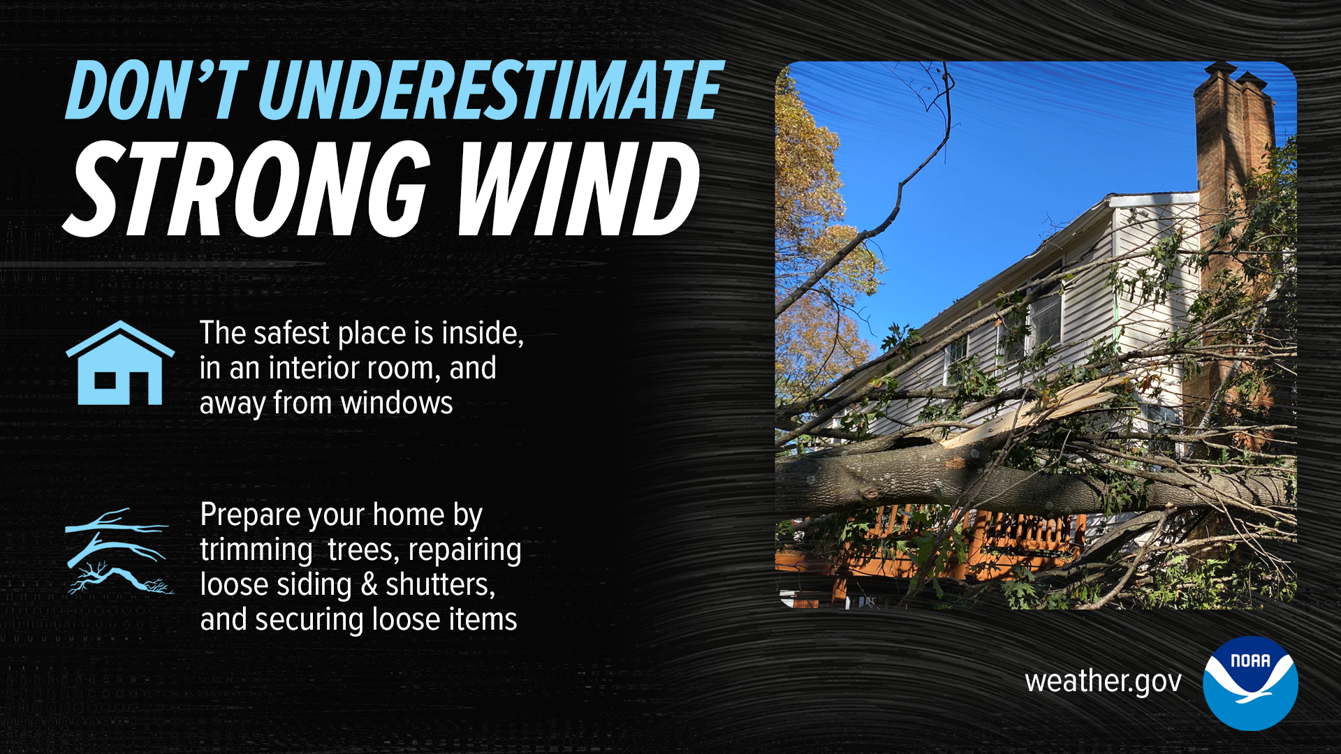
ACTION – Seek shelter indoors, away from windows, and close all doors. If you’re caught outdoors, avoid seeking refuge under trees or near tall structures, as they can be lightning magnets and may collapse in high winds. Crouch low, keeping as low to the ground as possible, and cover your head. Do not touch metal objects, including fences. Stay away from water bodies and electrical equipment. Stay informed by listening to weather updates through a battery-powered weather radio or smartphone app. By heeding these precautions, you can significantly reduce the risks associated with strong thunderstorm winds and stay safe during adverse weather conditions.
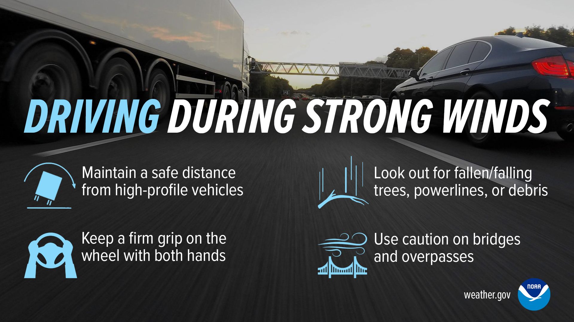
ACTION – When driving in the midst of strong thunderstorm winds, make sure to reduce your speed, turn on your headlights, and maintain a firm grip on the steering wheel. Watch out for flying debris and downed power lines. If visibility is severely compromised, pull over to a safe location, away from trees and other vehicles. Stay in the vehicle with your seatbelt fastened and your hazard lights on until the storm passes. Avoid parking under overpasses or bridges, as this can obstruct traffic flow. It’s essential to exercise caution, remain patient, and wait for the conditions to improve before resuming your journey.
ACTION – When driving high-profile vehicles, reduce your speed and maintain a firm grip on the steering wheel, as high-profile vehicles are more susceptible to wind gusts. Keep a safe distance from other vehicles to allow for sudden movements. Avoid overtaking other vehicles if wind speeds are excessive. Be prepared for sudden wind shifts, especially when exiting tunnels or passing tall structures. If conditions worsen and you feel unsafe, find a safe place to pull over, away from trees and other obstacles. Stay informed about weather conditions and heed warnings to ensure a safer journey during severe thunderstorm winds.
ACTION – Staying safe outdoors during strong thunderstorm winds with flying debris demands caution. Seek shelter indoors if possible. If you must remain outside, find a low-lying, open area away from trees, buildings, and other structures that could act as wind tunnels or launch debris. Cover your head and face with your arms or a sturdy object, and keep a low profile to minimize exposure to the wind. Be alert to flying objects and take shelter immediately if conditions worsen. Listening to weather updates on a battery-powered radio or a weather app can provide essential information to stay safe when confronted with the risks of strong thunderstorm winds and flying debris.
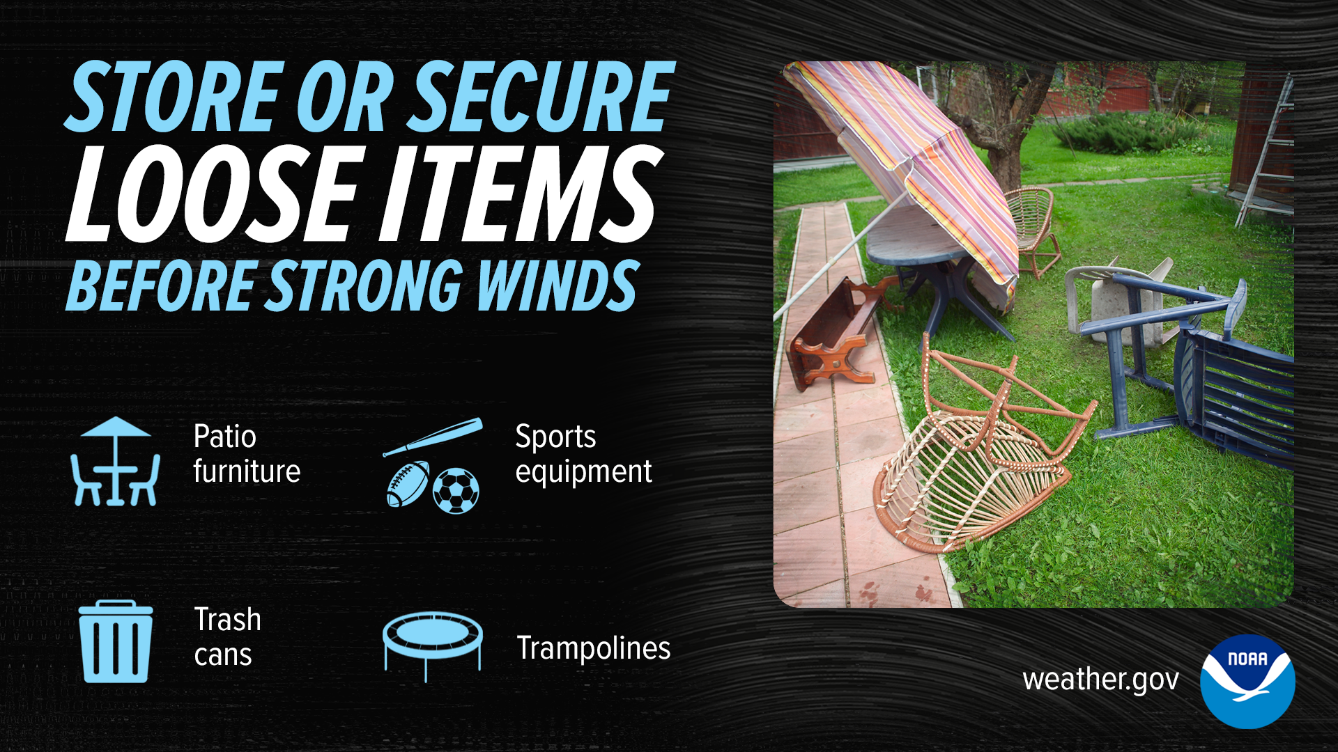
ACTION – When a storm is approaching, take a few minutes to gather and secure your outdoor items. Anchor lightweight furniture or items that could become projectiles in high winds, such as tables, chairs, or umbrellas. Store smaller items like cushions and decorations inside. Consider heavier objects like grills or statues, and place them in a sheltered area if possible. By taking these simple precautions, you can prevent damage to your property and reduce the risk of flying debris during the storm, making your outdoor space safer during severe weather events.
ACTION – What do you do after a storm that caused damage to your home or safe place? First, assess your immediate surroundings for any hazards, including downed power lines or unstable structures. Avoid any damaged areas or fallen trees. Take precautions when venturing outside and be mindful of potentially dangerous debris. Stay informed through weather updates on a battery-powered radio or mobile app. Contact local authorities and utility companies to report any damage or hazards. Always exercise caution and prioritize safety when navigating the aftermath of a storm, as unstable conditions may persist.
Conclusion
Severe weather preparedness is the process of planning and taking proactive measures to safeguard individuals, communities, and property from the potentially hazardous and often unpredictable effects of extreme meteorological events. These events can include thunderstorms, tornadoes, hurricanes, floods, winter storms, wildfires, and more. The objective of severe weather preparedness is to minimize the risks and enhance the resilience of individuals and communities in the face of these natural disasters.
Why We Should Be Prepared for Severe Weather:
Safety: The primary and most compelling reason for severe weather preparedness is the safety of human life. Severe weather events can be life-threatening, and preparedness measures can significantly reduce the risk of injury or death.
Property Protection: Preparedness helps protect homes, businesses, and valuable possessions from the potentially devastating effects of severe weather. Mitigating property damage can lead to substantial cost savings and faster recovery.
Economic Resilience: Being prepared can help reduce the economic impact of severe weather events. Businesses and communities that are prepared are better equipped to recover quickly, ensuring minimal disruption to local economies.
Public Health: Adequate preparedness can help minimize the impact on public health during and after severe weather events. This includes access to medical care, safe drinking water, and sanitation facilities.
Environmental Stewardship: Preparedness measures can also have positive environmental implications. By preventing hazardous materials from being released during disasters, we reduce potential harm to ecosystems and the environment.
How to Be Prepared for Severe Weather:
Stay Informed:
Monitor weather forecasts from reliable sources like the National Weather Service (NWS), local news, or weather apps.
Sign up for weather alerts and warnings specific to your location.
Create a Family Emergency Plan:
Develop a family emergency plan that includes designated meeting points, communication plans, and evacuation routes.
Ensure that all family members are aware of the plan and practice it regularly.
Build an Emergency Kit:
Assemble a well-stocked emergency kit that includes essentials such as non-perishable food, water, a first-aid kit, flashlights, batteries, a multi-tool, and important documents.
Secure Your Home:
Make structural improvements to your home, such as reinforcing the roof and windows.
Secure heavy items to prevent them from becoming projectiles in high winds.
Know Shelter Locations:
Identify safe locations in your home or community where you can take shelter during severe weather, such as basements or storm shelters.
Insurance Coverage:
Review your insurance policies to ensure you have adequate coverage for severe weather-related damage.
Understand your deductibles and policy limits.
Emergency Contacts:
Keep a list of important contacts, including family members, local emergency services, and medical professionals, readily available.
Practice Drills:
Regularly conduct severe weather drills with your family to ensure everyone knows how to respond in an emergency.
Stay Connected:
Keep a battery-powered or hand-crank radio to stay informed when power is out.
Have backup chargers for mobile phones to maintain communication.
Evacuation Plan:
If you live in an area prone to hurricanes, flooding, or wildfires, have an evacuation plan in place, including transportation options and a destination.
Community Resources:
Familiarize yourself with local community resources, such as emergency shelters and evacuation routes.
Help Neighbors:
Check on neighbors, especially those who may have difficulty preparing or evacuating on their own, and offer assistance.
What to Do During Severe Weather:
Listen to Authorities:
Follow the guidance and instructions provided by local authorities and emergency services. These professionals have the expertise to help keep you safe.
Take Shelter:
Move to a safe location as planned in your family emergency plan, such as a basement or an interior room on the lowest floor of a sturdy building.
Stay Informed:
Continue to monitor weather updates and alerts for any changes in the situation.
Use Emergency Kit:
Use your emergency kit, including food, water, and medical supplies, as needed.
Report Emergencies:
If safe to do so, report emergencies to local authorities and emergency services to ensure timely assistance.
Do Not Drive:
Avoid driving during severe weather, as road conditions may be hazardous. If you must drive, use extreme caution.
After the Storm:
After the severe weather event has passed, assess your surroundings for damage and check on neighbors.
Follow any post-storm safety guidelines provided by authorities, especially in the case of flooding or downed power lines.
In conclusion, severe weather preparedness is a shared responsibility and a fundamental aspect of community resilience. By staying informed, having a clear plan, and being proactive, individuals and communities can effectively mitigate the impact of severe weather events and increase their ability to bounce back from adversity. Preparedness is not just a precaution; it’s a powerful means of protecting lives, property, and the well-being of entire communities.
Resources
Tornado Safety
Learn about tornadoes, their destructive capabilities, how to prepare for tornadoes, and how to properly execute tornado safety!
Lightning Safety
Learn how to stay safe at outdoor activities during a lightning storm and how to practice proper lightning safety!
Storm Chasing 101
Learn about the art of storm chasing, how they pull it off, and how to get started as a storm chaser!
Weather Model Explanation
Learn how to interpret WC’s weather models it uses in its severe weather update blogs!
Radar Interpretation
Learn how to interpret weather radars and understand how they function to protect the general public!
Submit A Weather Report
Become a Texas Weather Center Storm Spotter today and order submit weather reports about storms in your area! WC will use your data to help better forecasting! Become one today for free as a WC Member!
Experience WC’s massive collection of historical weather data, weather models, weather predictions, and current weather conditions for DFW! Explore today!
Learn More Weather 101!
Types of Weather Section was made to inform viewers about all forms of severe weather that may be experienced or discussed about in WC posts! Here you can become weather aware and feel more prepared for severe weather! Each section includes details, graphics, videos, and resources to help the reader fully grasp the information given to them. Read more today!
“Severe Weather Preparedness 101” serves as a user-friendly hub, providing essential information to the public about dealing with severe weather. With an accessible and straightforward approach, this page aims to equip individuals with the knowledge and tools necessary to navigate through severe weather events confidently. Severe Weather Preparedness 101 breaks down the complexities of severe weather into easy-to-understand segments. It offers insights into what severe weather encompasses, including thunderstorms, tornadoes, hurricanes, and floods. This foundational knowledge helps readers grasp the range of natural phenomena they may encounter.
To better understand your vulnerability to severe weather, the page offers practical methods of risk assessment. By considering factors such as your geographical location, local climate patterns, and past weather occurrences, you can gauge your level of susceptibility to different types of severe weather. This awareness empowers you to tailor your preparedness efforts to the specific risks you may face.
But “Severe Weather Preparedness 101” goes beyond awareness; it’s all about proactive readiness. It provides a step-by-step guide on how to prepare for dangerous weather events. This includes creating a family emergency plan, which outlines what to do, where to go, and how to communicate during a crisis. Additionally, the page emphasizes the importance of assembling an emergency kit with essential supplies like non-perishable food, water, first-aid materials, and tools.
The ultimate message of the page is one of community and shared responsibility. It encourages readers not only to prepare themselves but also to extend the knowledge and resources to their friends and family. By sharing this resource during the severe weather season, you contribute to a safety network that extends well beyond your immediate circle.
Severe Weather Preparedness 101 ultimately aims to arm individuals with awareness and readiness to face the challenges of dangerous weather events. Make sure to share this valuable tool with your loved ones to help create a web of preparedness, ensuring that everyone can navigate through severe weather with confidence and safety!
Tornado Alley is constantly changing as forecasting and tornado research improves. The Tornado Alley is a zone of area that signifies the highest risk and most frequent number of tornadoes. Anyone in this area should be aware of storms especially since the conditions are usually more favorable for tornadoes in this region rather than in others. Of course, tornadoes still occur outside Tornado Alley but less often as records show. It is rare to see tornadoes on the coasts of America and it is most rare to see a tornado in California or Alaska.
Severe thunderstorms all start with key ingredients: moisture, warmth, and lift. For a thunderstorm to develop, it first needs to have rising warm moist air. Rising warm air moves upward in the atmosphere creating puffy cumulus clouds on its way. This will continue as long as there is lift. Lift is provided by either convective heating (the suns heating of the atmosphere) and/or by difference in air density. This is known as the updraft of the thunderstorm. At some point, the cloud will reach the CAPE. This is a layer of cold air in the atmosphere, at about 30,000 feet, which prevents cloud growth beyond that point in most cases. Many weather models can tell you the strength of the CAPE in the atmosphere on a given day. When storms become severe, they generally have to punch through the CAPE. They do this due to their strong updrafts and other various conditions. Once the CAPE is broken, the thunderstorm can continue growing. At this point, the storms warm air will condense into water droplets and begin to cool due to the cold air above. This causes sinking cold air. This sinking cold air begins to form what’s known as a downdraft. This downdraft will bring down heavy rain and most likely hail. Now we have a working severe thunderstorm.
At different stages of a thunderstorm, they could turn to mesocyclonic storms. This means that the storm’s core rotates due to the wind speed differences at the different altitudes of the atmosphere (known as wind shear). This is one of the main steps in how a tornado must come to form. Let’s see how a tornado must form.
Tornado Formation
The basics of a tornado’s formation begins with the typical elements needed for storm development. Once the storm has formed, the element that really grows the storm ‘upward” is the warm, convective, moist, spring/summer air. Remember, whenever you see a cloud grow UPWARDS with towering columns, or even an “anvil-shaped” top, those are signs of a strong developing storm. Next, the storm could get the characteristics of a mesocyclone storm. A mesocyclone is formed when a strong updraft flows into a storm (all strong storms have one) and it meets with upper level winds. This is known as wind shear. Think of three air streams of wind flowing horizontally: One at 10,000 ft, the other at 20,000 ft, and the last at 30,000 ft. When you have a storm growing upwards (updraft winds with it), the updraft vertical winds will interfere with those horizontal winds more and more the higher the storm grows. This will form a rotating funnel within the storm. Back down on the surface, you may notice a wall cloud or a funnel if conditions are right. After, a tornado will potentially form. Just remember that a mesocyclone is one of the most important parts of a severe thunderstorm.
Thunderstorm Types
Supercell: A Supercell, an awe-inspiring meteorological marvel, gives rise to severe thunderstorms renowned for their sustained rotating winds fueled by a persistent updraft. This dynamic and formidable atmospheric system may unleash a variety of severe weather elements, including hail or, in more menacing scenarios, tornadoes. A defining characteristic of supercells is the presence of a mesocyclone, an enduring and deeply rotating updraft that imparts a swirling quality to these storms. Due to this distinctive feature, they are often colloquially referred to as “rotating thunderstorms.” Supercells typically maintain their intensity for a duration spanning approximately 2 to 4 hours, during which they exhibit a remarkable interplay of atmospheric forces.
Single-Cell Thunderstorm: In stark contrast, Single-Cell Thunderstorms, while occasionally potent, tend to confine their meteorological theatrics to copious rainfall and electrifying displays of lightning. These solitary storm cells typically lack the necessary energy and dynamics to foster the development of severe weather conditions or produce robust updrafts.
Squall Line: A Squall Line, a meteorological juggernaut of considerable magnitude, takes form as a formidable row of thunderstorms materializes along or just ahead of an advancing cold front. These formidable assemblages of storms are renowned for their rapid forward movement, often resulting in widespread wind damage and the potential for tornadoes. Remarkably, squall lines possess the capacity to traverse vast expanses, spanning hundreds of miles horizontally and stretching an impressive 1,000 miles from zenith to nadir.
Multi-Cell Thunderstorm: Multi-Cell Thunderstorms, on the other hand, represent intricate and multifaceted meteorological spectacles, harboring a multitude of diverse sections and individual storm cells within their convective embrace. These meteorological tapestries typically exhibit an array of anvil heads and possess the potential to evolve into formidable tempests. Notably, the life cycles of individual cells within these intricate convective systems are marked by distinct stages, including the Growing, Mature, and Dissipating phases. As a result, different portions of the storm may find themselves at various stages of development at different times, creating a dynamic landscape where certain areas exhibit heightened intensity while others wane in strength.
Storm Risks
There are several risks that come with storms and bad weather. Below are just a few examples of storm risks and the dangers they present.
Tornadoes
Tornadoes are extremely dangerous and can be one of the most destructive forms of weather. Tornadoes are sometimes unpredictable and can strike a location with incredible speed and power. The current warning time for a tornado is about 13 minutes, but sometimes its so much less. It is important that you act IMMEDIATELY when you are under a tornado warning and get to your safe room. Tornadoes in most cases are too hard to see until it’s too late. Rain wrapped tornadoes or night tornadoes are this way especially.
Storm Debris
Storm debris is extremely dangerous. Debris is deadly. After a storm has passed over, debris may lay in its path. Downed powerlines pose an extreme threat to people around. Flying debris can damage structures and flying through windows as if they were missiles. Shattered glass from hail can be very dangerous too, whether from your vehicle or from your place of residence. If you spot debris on a roadway, do not try to pass it! You will most likely get stuck. Finally, if you are caught out in flying debris, curl up into a fetal position with your head down and cover your head with your hands clasped tightly over.
Flooding
Flooding is one of the most destructive forms of dangerous weather worldwide. Every country in the world almost has experienced deadly flooding. Flooding is simply caused by the displacement of water or excess rainfall that can flow through populated areas and cause damage. It is important to never be in situations where you are in a flood zone when a rainstorm strikes, like for example a creek bed. It is also important you stay alerted by flash flood warnings in your area especially if you live by rivers or lakes. Finally, traveling on roadways during heavy rainfall can be very dangerous due to water buildup in ditches that may cover the roadway or a hydroplaning risk with your vehicle.
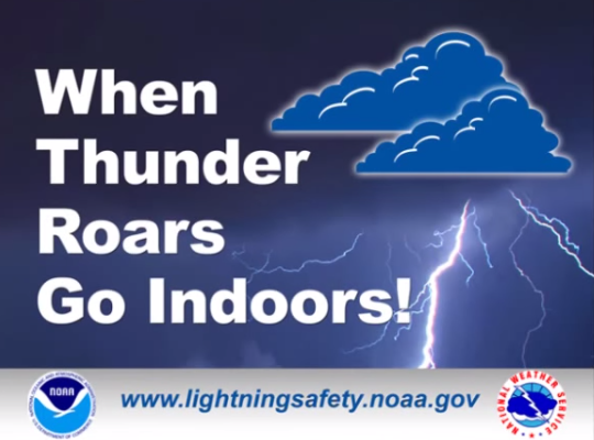
Lightning
Lightning injures hundreds of people every year just in the US. Lightning from a storm can sometimes even strike you or a structure from over 50 miles away! It is important to never be outside especially out in the open when there is active cloud-to-ground lightning occurring. Another important note is to never operate any water equipment, swim, or take a shower during a thunderstorm. Lightning that strikes the ground can transfer into water in the pipes and pose a risk of electrocution.
Hail
Hail can be extremely destructive as well. Billions of dollars of roof and vehicle damage occur every year due to hail damage. Hail can not only be a huge threat to your vehicle and/or your house, but also to you. Sometimes hail can grow larger than softballs. With a hailstorm producing hail of that size plus the rate of decent, it could easily cause casualties if anyone was caught outdoors. It is important to listen to the outdoor warning sirens about large hail and make sure you stay indoors away from windows during a hailstorm!
Damaging Winds
Damaging winds especially straight line winds, can be very dangerous. Not only can they cause extensive structural damage, but they can carry storm debris very easily. Flying debris is a huge concern with high winds. That’s why staying away from windows during high winds and inside a sturdy structure is crucial. Additionally, driving during high winds with high-profile vehicles can be extremely risky.
Understanding When Storms Become Severe
One of the biggest things that can benefit you if the knowledge of determining what weather you should be concerned about and what weather is not concerning. There are over 100,000 thunderstorms each year in the U.S. alone. Not all of them are severe or are concerning to your safety. So how can you know when a storm is really severe? There are several fairly simple methods you can use to approach this.
+
Severe Thunderstorms Every Yearin the US
$ Billion
In Damage Every Year in the US
Minutes
Average Warning Time for a Tornado
While a simple weather app can give you the forecast, not all of them will give you the details needed to help determine if severe weather will occur or not. Many find that some weather apps are very inconsistent, and they don’t give them straight answers.
There are a few alternatives that can give you information quickly.
SPC outlooks are some of the best ways to determine risk levels for severe weather in your area! SPC makes it easy to understand your risks. There are 5 outlook levels:
Marginal – Scattered storms capable of severe hail, localized damaging winds, and a low chance of tornadoes. 1 Inch hail, 60 MPH winds, and/or a weak localized tornado typically could happen in this outlook level.
Slight – Increased confidence that some storms will be severe with higher a risk of severe hail, damaging winds, and/or tornadoes than the previous outlook level. 1-2 Inch hail, 70 MPH winds, and/or a couple weak tornadoes typically could happen in this outlook level
Enhanced – High confidence that many storms will be severe with higher a risk of severe hail, damaging winds, and/or tornadoes than the previous outlook level. 2-3 Inch hail, 70-80 MPH winds, and/or a couple tornadoes typically could happen in this outlook level
Moderate – High confidence that most storms will be severe with a much higher risk of severe hail, damaging winds, and/or tornadoes than the previous outlook level. 3-4 Inch hail, 80 MPH winds, and/or a few tornadoes (some strong) typically could happen in this outlook level
High – Very high confidence that a severe weather outbreak will occur in this area with a much higher risk of severe hail, damaging winds, and/or tornadoes than the previous outlook level. 4+ Inch hail, 80+ MPH winds, and/or several strong tornadoes (some very violent) typically could happen in this outlook level. This outlook is usually very rarely issued (1-2 times a year for the US)
SPC has several days that it displays outlooks for the public. Days 1-3 show convective outlooks levels (above), and Days 4-8 are % chances of severe weather. It is fairly unlikely that there are risk areas for Days 4-8 due to the fact long range severe weather forecasting can be inaccurate sometimes.
Day 1-2 displays the convective outlook levels and also the % chance of specific threats like hail, wind, and tornadoes.
See all of SPC’s outlooks displayed on WC’s page SPC Outlooks!
The National Weather Service of Fort Worth Texas issues weather graphics and info graphs daily for the area. Many of these graphics are for severe weather watches, alerts, and predictions for coming storms. These can be very helpful and are extremely easy to understand and interpret. WC has a slider of all the latest NWS forecasts on its homepage! Some of these graphics are so much more helpful than weather apps when it comes severe weather forecasting. You can get a ton of information for the next coming days for severe weather risks by just going to NWS FTW!
Radar Scope is one of the most affordable advanced weather radars for weather lovers and storm chasers! It includes many useful features for tracking storms and has very high detailed reflectivity layer which provides accurate storm location and storm analysis! WC is a proud user of Radar Scope and encourages you to get Radar Scope as well! Not only is this radar great for the general public, but storm chasers can use this radar too, especially new storm chasers! It doesn’t take long to learn how to operate this radar and you can always upgrade your plan later to access more features!
Radar Scope is only a one-time payment of $10 for an IOS device and $30 for Windows! Upgrading to Tier I or Tier II will unlock you more benefits and features in the app if you choose to upgrade. Click below to download the app for yourself!
There are a couple other professional radars WC would like to mention:
The first radar WC would like to mention is Omega Radar. It is a fairly newer radar and has been gaining popularity fast lately. It includes a lot of features similar to Radar Scope and it is trying to compete with Radar Scope in many ways. There are several amazing features like 3D radar that Omega Radar offers that others don’t! While the cheapest plan is $49.99/year, Omega Radar is still a good second option.
This last radar WC would like to mention is hands down the most complex advanced radar out there for the general public to use. It is called WSV3. This radar offers the most complex and advanced features any radar could offer for the public. It even takes a good computer to run this radar. This just shows the amazing power of this program. While spending $240/year to own this radar may not be worth it for most people except for storm chasers, this radar is definitely the most advanced out there. WC highly recommends this radar for professional storm chasers who are willing to up their game and invest a little bit of money.
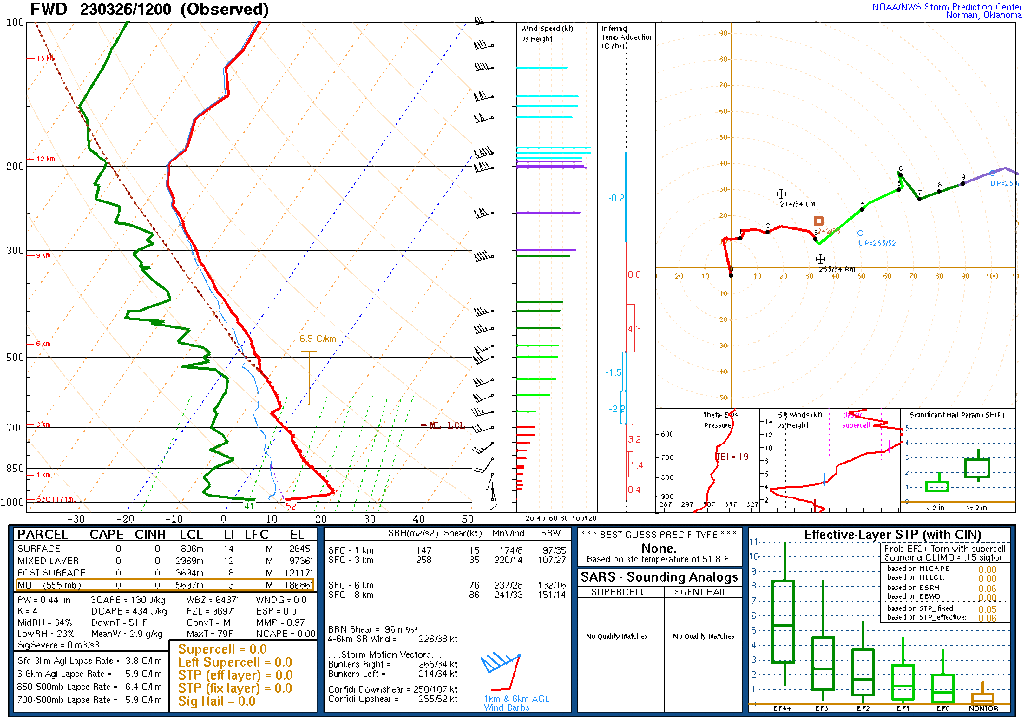
For the advanced few out there, this page is for you! Learn some of the basic ins and outs of a weather sounding. Remember a weather sounding is a compilation of data collected from weather balloons that are launched at hundreds of locations all around the US. If you want to read the page, click on the button below!
📑Outlook: An outlook means a form of severe weather is possible for that given area in the next 5-7 days. Generally seen in the form of hazardous weather outlooks or other forms. Also can be a convective outlook issued by SPC which indicates risk level areas for severe weather that day.
🚩Advisory: Typically used to describe a weather event that is likely to occur, for example a Wind Advisory. Advisories are commonly and typically only issued for non-severe weather events.
🛑Watch: A watch means that conditions are favorable for severe weather. Storm can develop in the next few hours and can become severe quickly. Each watch issued has different hazards listed for what to expect in the storms. Watches are typically issued a couple hours before the first storms begin to develop and turn severe.
⚠️Warning: A warning is issued when there is an ongoing imminent threat to that location of severe weather. Action must be taken IMMEDIATELY!
What are Outdoor Sirens?
Outdoor warning sirens are made to protect the general public from dangerous weather. Many believe they are only sounded for tornadoes. That’s not true. These sirens, while they are mostly sounded for tornadoes, can be sounded for very large hail and damaging winds. These sirens are sounded first to warn people who are outdoors or traveling. It is loudest for them, so immediate action is needed in order to get indoors and safe. People indoors should heed the warning and enter their safe room in their home immediately. If the siren is for large hail, do NOT be by any of the windows of your home. For both tornadoes and high winds, seek shelter in the safe room of your home immediately.
What Never To Do
⚠️Never Be Unprepared for Severe Weather!
When severe weather strikes, you will want to be prepared! Following the latest weather sources like WC discussed above will save you from un-wanted surprises in the future when it comes to severe weather. No one wants to be caught out in a tornado while driving down the highway, yet many are! Knowing what to expect will allow you to plan ahead so that you can stay home if possible, shift your day schedule around, or plan alternate travel routes to ensure you can stay safe during an active severe weather day!
⚠️Never Try to Spot a Tornado!
When outdoor warning sirens are blaring and a tornado warning is issued for your area, some people’s curiosity gets the best of them. Please DO NOT go outside to try to spot a tornado! Not only is this extremely dangerous, but you will likely not even be able to spot the tornado. Many tornadoes can be rain wrapped or hidden by tall trees or structures. Many can be sudden and approach out of no-where. Night tornadoes are essentially impossible to see. Just don’t do it! Get to your safe room immediately and follow your local weather news for information!
⚠️Never Ignore Warnings!
Warnings are made for your protection! Warnings usually indicate life threatening severe weather that is imminent for your location. It is important you act immediately since warning time isn’t always very long! While you may not want to always follow the warning, just think of it as a safety precaution that can save your life. Think what would happen to you if you never took the necessary safety precautions and you got caught off guard by extreme hail or a tornado? Warnings save lives, and so can you if you follow them and encourage your friends and family to as well.
5 Ways to Prepare for Severe Weather
1. Have a Storm Plan
Be prepared for severe weather that’s in the coming week and plan your schedule accordingly to allow flexibility if dangerous weather did strike. Be sure you have emergency supplies.
When forecasted severe weather is only a day away from occurring, make sure you know your safe room and have planned your day schedule accordingly.
Continually check for weather updates online, on apps, or your local news station while severe weather is immanent and be sure to take action if any weather warnings were to be issued!
2. Understand Possible Weather Hazards
ACTION – Take shelter immediately in a sturdy structure away from windows in an interior room.
ACTION – Move indoors away from windows.
ACTION – Move indoors if you hear thunder.
ACTION – Move indoors away from windows into interior rooms.
ACTION – Avoid rising creeks and water-covered roads.
3. Have a Way to Receive Weather Warnings
Download a Weather App – Weather apps are very useful in so many ways in our daily lives. Not only do they give us the forecast, but most out there have weather alert notifications that come right to you phone! Check out the 7 Best weather Apps blog to find out the best weather app!
Enable Emergency Weather Alerts – On all iPhones after IOS 15.4, emergency weather alerts are delivered straight to your phone, bypassing silent mode or “do not disturb” so that you can receive the necessary warning for the life-threatening event possible in your area at that time.
4. Tune into your local Weather News Channel
Stay Updated with live weather coverage – Your local news station will always cover live severe weather in your area. They will give out valuable life-saving information and live warnings that are issued. You can stay updated on everything with your local news station when storms strike!
Invest in an emergency weather radio – Even if you have access to a TV for live weather coverage, it is a good idea to have an emergency weather radio since its portable, able to be with you in your safe room, and useful in cases where the power is out.
5. Understand Weather Models
Be knowledgeable on weather models – If you understand weather models like for example WC’s weather model, you can better understand if your area is at risk for severe weather and what to expect. There are many weather models out there including National Weather Service, Storm Prediction Center, Pivotal Weather, etc
Search for weather models that you understand best – WC recommends searching “NWS FTW” in your search engine. This page shows several relevant graphics that are extremely helpful in determining the severe weather risks in your area
After the Storm
ACTION – Communicate via text only if at all possible. Network channels will be extremely slow in some cases and data transferring will be impacted greatly.
ACTION – Conserve battery life on all your devices. Power outages are common with bad/destructive storms
ACTION – Stay indoors and away from downed powerlines, dangerous debris, etc. Wait until the storm has passed completely before going outdoors.
Survival Items: first aid kit, medicine, food & water.
Other Supplies: phone chargers, external batteries, weather radio, spare cash, backpack, shoes, bike helmets (for tornado warnings), multitool (optional), etc
Important Documents: Proof of residential ownership, insurance, personal indentation, other important information
ACTION – Identify safe meeting places at home, work, school, etc. This will be the place where you go to meet up after the event of a natural disaster if members were separated from each other.
ACTION – Know your exits in the building you are in so that in the event of a natural disaster you know how to exit safely. Know your hallways, exits, stairwells, etc. Avoid use of elevators!
ACTION – Have a backup location to stay in case of evacuation or damage/destruction to permanent residence.
Strong Wind Safety Tips
ACTION – Seek shelter indoors, away from windows, and close all doors. If you’re caught outdoors, avoid seeking refuge under trees or near tall structures, as they can be lightning magnets and may collapse in high winds. Crouch low, keeping as low to the ground as possible, and cover your head. Do not touch metal objects, including fences. Stay away from water bodies and electrical equipment. Stay informed by listening to weather updates through a battery-powered weather radio or smartphone app. By heeding these precautions, you can significantly reduce the risks associated with strong thunderstorm winds and stay safe during adverse weather conditions.
ACTION – When driving in the midst of strong thunderstorm winds, make sure to reduce your speed, turn on your headlights, and maintain a firm grip on the steering wheel. Watch out for flying debris and downed power lines. If visibility is severely compromised, pull over to a safe location, away from trees and other vehicles. Stay in the vehicle with your seatbelt fastened and your hazard lights on until the storm passes. Avoid parking under overpasses or bridges, as this can obstruct traffic flow. It’s essential to exercise caution, remain patient, and wait for the conditions to improve before resuming your journey.
ACTION – When driving high-profile vehicles, reduce your speed and maintain a firm grip on the steering wheel, as high-profile vehicles are more susceptible to wind gusts. Keep a safe distance from other vehicles to allow for sudden movements. Avoid overtaking other vehicles if wind speeds are excessive. Be prepared for sudden wind shifts, especially when exiting tunnels or passing tall structures. If conditions worsen and you feel unsafe, find a safe place to pull over, away from trees and other obstacles. Stay informed about weather conditions and heed warnings to ensure a safer journey during severe thunderstorm winds.
ACTION – Staying safe outdoors during strong thunderstorm winds with flying debris demands caution. Seek shelter indoors if possible. If you must remain outside, find a low-lying, open area away from trees, buildings, and other structures that could act as wind tunnels or launch debris. Cover your head and face with your arms or a sturdy object, and keep a low profile to minimize exposure to the wind. Be alert to flying objects and take shelter immediately if conditions worsen. Listening to weather updates on a battery-powered radio or a weather app can provide essential information to stay safe when confronted with the risks of strong thunderstorm winds and flying debris.
ACTION – When a storm is approaching, take a few minutes to gather and secure your outdoor items. Anchor lightweight furniture or items that could become projectiles in high winds, such as tables, chairs, or umbrellas. Store smaller items like cushions and decorations inside. Consider heavier objects like grills or statues, and place them in a sheltered area if possible. By taking these simple precautions, you can prevent damage to your property and reduce the risk of flying debris during the storm, making your outdoor space safer during severe weather events.
ACTION – What do you do after a storm that caused damage to your home or safe place? First, assess your immediate surroundings for any hazards, including downed power lines or unstable structures. Avoid any damaged areas or fallen trees. Take precautions when venturing outside and be mindful of potentially dangerous debris. Stay informed through weather updates on a battery-powered radio or mobile app. Contact local authorities and utility companies to report any damage or hazards. Always exercise caution and prioritize safety when navigating the aftermath of a storm, as unstable conditions may persist.
Conclusion
Severe weather preparedness is the process of planning and taking proactive measures to safeguard individuals, communities, and property from the potentially hazardous and often unpredictable effects of extreme meteorological events. These events can include thunderstorms, tornadoes, hurricanes, floods, winter storms, wildfires, and more. The objective of severe weather preparedness is to minimize the risks and enhance the resilience of individuals and communities in the face of these natural disasters.
Why We Should Be Prepared for Severe Weather:
Safety: The primary and most compelling reason for severe weather preparedness is the safety of human life. Severe weather events can be life-threatening, and preparedness measures can significantly reduce the risk of injury or death.
Property Protection: Preparedness helps protect homes, businesses, and valuable possessions from the potentially devastating effects of severe weather. Mitigating property damage can lead to substantial cost savings and faster recovery.
Economic Resilience: Being prepared can help reduce the economic impact of severe weather events. Businesses and communities that are prepared are better equipped to recover quickly, ensuring minimal disruption to local economies.
Public Health: Adequate preparedness can help minimize the impact on public health during and after severe weather events. This includes access to medical care, safe drinking water, and sanitation facilities.
Environmental Stewardship: Preparedness measures can also have positive environmental implications. By preventing hazardous materials from being released during disasters, we reduce potential harm to ecosystems and the environment.
How to Be Prepared for Severe Weather:
Stay Informed:
Monitor weather forecasts from reliable sources like the National Weather Service (NWS), local news, or weather apps.
Sign up for weather alerts and warnings specific to your location.
Create a Family Emergency Plan:
Develop a family emergency plan that includes designated meeting points, communication plans, and evacuation routes.
Ensure that all family members are aware of the plan and practice it regularly.
Build an Emergency Kit:
Assemble a well-stocked emergency kit that includes essentials such as non-perishable food, water, a first-aid kit, flashlights, batteries, a multi-tool, and important documents.
Secure Your Home:
Make structural improvements to your home, such as reinforcing the roof and windows.
Secure heavy items to prevent them from becoming projectiles in high winds.
Know Shelter Locations:
Identify safe locations in your home or community where you can take shelter during severe weather, such as basements or storm shelters.
Insurance Coverage:
Review your insurance policies to ensure you have adequate coverage for severe weather-related damage.
Understand your deductibles and policy limits.
Emergency Contacts:
Keep a list of important contacts, including family members, local emergency services, and medical professionals, readily available.
Practice Drills:
Regularly conduct severe weather drills with your family to ensure everyone knows how to respond in an emergency.
Stay Connected:
Keep a battery-powered or hand-crank radio to stay informed when power is out.
Have backup chargers for mobile phones to maintain communication.
Evacuation Plan:
If you live in an area prone to hurricanes, flooding, or wildfires, have an evacuation plan in place, including transportation options and a destination.
Community Resources:
Familiarize yourself with local community resources, such as emergency shelters and evacuation routes.
Help Neighbors:
Check on neighbors, especially those who may have difficulty preparing or evacuating on their own, and offer assistance.
What to Do During Severe Weather:
Listen to Authorities:
Follow the guidance and instructions provided by local authorities and emergency services. These professionals have the expertise to help keep you safe.
Take Shelter:
Move to a safe location as planned in your family emergency plan, such as a basement or an interior room on the lowest floor of a sturdy building.
Stay Informed:
Continue to monitor weather updates and alerts for any changes in the situation.
Use Emergency Kit:
Use your emergency kit, including food, water, and medical supplies, as needed.
Report Emergencies:
If safe to do so, report emergencies to local authorities and emergency services to ensure timely assistance.
Do Not Drive:
Avoid driving during severe weather, as road conditions may be hazardous. If you must drive, use extreme caution.
After the Storm:
After the severe weather event has passed, assess your surroundings for damage and check on neighbors.
Follow any post-storm safety guidelines provided by authorities, especially in the case of flooding or downed power lines.
In conclusion, severe weather preparedness is a shared responsibility and a fundamental aspect of community resilience. By staying informed, having a clear plan, and being proactive, individuals and communities can effectively mitigate the impact of severe weather events and increase their ability to bounce back from adversity. Preparedness is not just a precaution; it’s a powerful means of protecting lives, property, and the well-being of entire communities.
Resources
Tornado Safety
Learn about tornadoes, their destructive capabilities, how to prepare for tornadoes, and how to properly execute tornado safety!
Lightning Safety
Learn how to stay safe at outdoor activities during a lightning storm and how to practice proper lightning safety!
Storm Chasing 101
Learn about the art of storm chasing, how they pull it off, and how to get started as a storm chaser!
Weather Model Explanation
Learn how to interpret WC’s weather models it uses in its severe weather update blogs!
Radar Interpretation
Learn how to interpret weather radars and understand how they function to protect the general public!
Submit A Weather Report
Become a Texas Weather Center Storm Spotter today and order submit weather reports about storms in your area! WC will use your data to help better forecasting! Become one today for free as a WC Member!
Experience WC’s massive collection of historical weather data, weather models, weather predictions, and current weather conditions for DFW! Explore today!
Learn More Weather 101!
Types of Weather Section was made to inform viewers about all forms of severe weather that may be experienced or discussed about in WC posts! Here you can become weather aware and feel more prepared for severe weather! Each section includes details, graphics, videos, and resources to help the reader fully grasp the information given to them. Read more today!